Enable Location

We need your location to show you interesting places around you

Discover nearby places

Find interesting locations and hidden gems around you

Precise directions

Get accurate directions and distances to places

Your location is never shared with other users. It's only used when you tap the location button.

McClellan Creek National Grassland

Log in to your account

Start exploring — it's free

Trusted by 66,650 travelers worldwide

Continue with Google
Continue with Apple
or

We will send you a code to connect

By continuing, you accept our Terms and Conditions and our Privacy Policy

Check your inbox

We've sent a pincode in your inbox. Please enter the code below.

McClellan Creek National Grassland
Discussion Reviews 1 Photos
3.2k Popularity

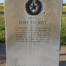
McClellan Creek National Grassland, Protected grassland in Gray County, Texas, US.

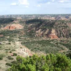
McClellan Creek National Grassland is a federally protected grassland in Gray County, in the northern Texas Panhandle, covering open plains with native grasses and a central reservoir. The terrain is mostly flat with gently rolling sections, and the land provides habitat for a range of wildlife species.

In the 1930s, the US government bought the land from private farmers whose fields had been badly damaged by drought and the soil erosion of the Dust Bowl. The area was then replanted and managed as public grassland to restore the soil.

The grassland sits in the heart of the Texas Panhandle and gives visitors a sense of what the open prairie looked like before farming took over. Walking through the area, you can see native grasses, flat open land, and wildlife that belong to this part of the Great Plains.

The area has campgrounds with electrical hookups, showers, and waste stations, and visitors can also hike, fish, and ride ATVs. Because the land is very open, it is worth checking the weather before you go, as wind and storms can move in quickly on the plains.

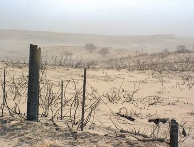
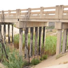
A large fire in 2006 burned through a sizable portion of the grassland along the highway and permanently changed the mix of plants growing there. Fires like this are actually a natural part of grassland life, clearing old growth and making room for new plants to take hold.

The community of curious travelers

AroundUs brings together thousands of curated places, local tips, and hidden gems, enriched daily by 60,000 contributors worldwide.

Start exploring
Location
Elevation above the sea
891 m
GPS coordinates
35.21070,-100.86900
Latest update
March 3, 2026 13:54
Around this place
Palo Duro Canyon
United States of America

Palo Duro Canyon

78.3 km
JA Ranch
United States of America

JA Ranch

52.6 km
Leaning Tower of Britten
United States of America

Leaning Tower of Britten

19.4 km
Fort Elliott
United States of America

Fort Elliott

50.7 km
Devils Rope Barbed Wire Museum
United States of America

Devils Rope Barbed Wire Museum

24.8 km
Texas Air & Space Museum
United States of America

Texas Air & Space Museum

75.6 km
Charles and Mary Ann Goodnight Ranch House
United States of America

Charles and Mary Ann Goodnight Ranch House

34.9 km
Magnolia Service Station
United States of America

Magnolia Service Station

79.8 km
Carson County Square House Museum
United States of America

Carson County Square House Museum

48.9 km
Route 66 Bridge over the Chicago, Rock Island and Gulf Railroad
United States of America

Route 66 Bridge over the Chicago, Rock Island and Gulf Railroad

69.4 km
Cruz Gigante de Groom
United States of America

Cruz Gigante de Groom

23.1 km
Donley County Courthouse and Jail
United States of America

Donley County Courthouse and Jail

30.5 km
Roberts County Courthouse
United States of America

Roberts County Courthouse

57.7 km
Hall County Courthouse
United States of America

Hall County Courthouse

61.9 km
Gray County Courthouse
United States of America

Gray County Courthouse

37.3 km
Devil's Rope Museum
United States of America

Devil's Rope Museum

24.8 km
Pioneer West Museum
United States of America

Pioneer West Museum

56.5 km
Pampa City Hall
United States of America

Pampa City Hall

37.2 km
Freedom Museum USA
United States of America

Freedom Museum USA

37.6 km
Palo Duro State Park
United States of America

Palo Duro State Park

78.6 km
Ritz Theatre
United States of America

Ritz Theatre

71.7 km
Sandell Drive-In
United States of America

Sandell Drive-In

29.7 km
Morley Theatre
United States of America

Morley Theatre

69.9 km
Texas Outdoor Musical
United States of America

Texas Outdoor Musical

78.3 km
White Deer Land Company Building
United States of America

White Deer Land Company Building

37 km
McLean Commercial Historic District
United States of America

McLean Commercial Historic District

24.5 km
Phillips 66 Station (McLean, Texas)
United States of America

Phillips 66 Station (McLean, Texas)

24.4 km
Roberts County Museum
United States of America

Roberts County Museum

57.5 km
Show the full map
Reviews
Share your experience

No review yet

Discussions
Start a discussion...

No discussion yet

« McClellan Creek National Grassland - Protected grassland in Gray County, Texas, US » is provided by Around Us (aroundus.com). Images and texts are derived from Wikimedia project under a Creative Commons license. You are allowed to copy, distribute, and modify copies of this page, under the conditions set by the license, as long as this note is clearly visible.

Discover hidden gems everywhere you go!

From secret cafés to breathtaking viewpoints, skip the crowded tourist spots and find places that match your style. Our app makes it easy with voice search, smart filtering, route optimization, and insider tips from travelers worldwide. Download now for the complete mobile experience.

Around Us App Screenshot

A unique approach to discovering new places

Le Figaro

All the places worth exploring

France Info

A tailor-made excursion in just a few clicks

20 Minutes

Around Us
Travel Guide & Maps
Download

Send to your phone

QR Code
1

Open the camera app on your mobile.

2

Point at the QR code with your camera. A notification will appear.

3

Tap the notification to open the link.