Enable Location

We need your location to show you interesting places around you

Discover nearby places

Find interesting locations and hidden gems around you

Precise directions

Get accurate directions and distances to places

Your location is never shared with other users. It's only used when you tap the location button.

Magnolia Service Station

Log in to your account

Start exploring — it's free

Trusted by 62,059 travelers worldwide

Continue with Google
Continue with Apple
or

We will send you a code to connect

By continuing, you accept our Terms and Conditions and our Privacy Policy

Check your inbox

We've sent a pincode in your inbox. Please enter the code below.

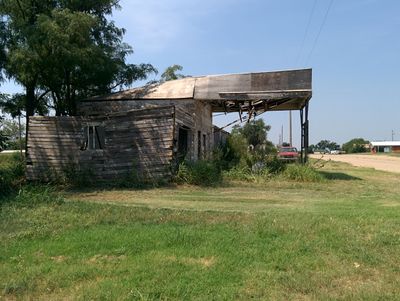
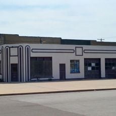
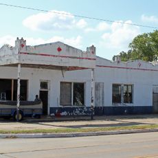
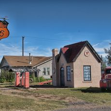
Magnolia Service Station, Historic filling station in Texola, United States.

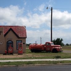
The Magnolia Service Station is a historic filling station in Texola featuring a central brick building designed in a house-style typical of 1930s petroleum stations. The structure now shows deterioration with a partially collapsed canopy, and its original side garage has been completely removed from the site.

The station was built in 1930 and operated as one of the westernmost fuel stops in Oklahoma along U.S. Route 66. It switched from Magnolia to Phillips 66 as its petroleum supplier in 1955 and closed permanently in the 1960s due to economic decline.

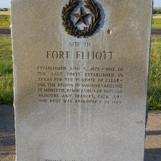
The filling station represents the early development of automobile infrastructure in America, marking the transition to motorized transportation across the country.

The building sits on open ground in Texola and is visible from the road. Access to the site is straightforward, though visitors should be aware that the property is unfenced and the structures may be unstable.

The station remains on the landscape as a tangible reminder of small-town travel infrastructure that has largely disappeared from rural routes. Few people today recognize these roadside structures as vital checkpoints in the development of American automobile culture.

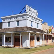
The community of curious travelers

AroundUs brings together thousands of curated places, local tips, and hidden gems, enriched daily by 60,000 contributors worldwide.

Start exploring
Location
Inception
1930
GPS coordinates
35.21901,-99.99167
Latest update
December 18, 2025 11:40
Around this place
Foss Reservoir
United States of America

Foss Reservoir

79.9 km
Quartz Mountain Nature Park
United States of America

Quartz Mountain Nature Park

72.4 km
McClellan Creek National Grassland
United States of America

McClellan Creek National Grassland

79.8 km
Fort Elliott
United States of America

Fort Elliott

53.7 km
Devils Rope Barbed Wire Museum
United States of America

Devils Rope Barbed Wire Museum

55.1 km
Washita National Wildlife Refuge
United States of America

Washita National Wildlife Refuge

80 km
Storm House
United States of America

Storm House

56.8 km
Beckham County Courthouse
United States of America

Beckham County Courthouse

33.3 km
Route 66 Bridge over the Chicago, Rock Island and Gulf Railroad
United States of America

Route 66 Bridge over the Chicago, Rock Island and Gulf Railroad

10.4 km
Perryman Ranch Headquarters
United States of America

Perryman Ranch Headquarters

70.7 km
Sayre Champlin Service Station
United States of America

Sayre Champlin Service Station

32.9 km
Sayre Downtown Historic District
United States of America

Sayre Downtown Historic District

33 km
National Rt 66 and Transportation Museum
United States of America

National Rt 66 and Transportation Museum

54.8 km
Canute Service Station
United States of America

Canute Service Station

68.4 km
J. W. Danner House
United States of America

J. W. Danner House

33.1 km
Greer County Courthouse
United States of America

Greer County Courthouse

58.8 km
Roberts County Courthouse
United States of America

Roberts County Courthouse

78.7 km
Hall County Courthouse
United States of America

Hall County Courthouse

74 km
Hobart City Hall
United States of America

Hobart City Hall

84.6 km
Devil's Rope Museum
United States of America

Devil's Rope Museum

55.1 km
Pioneer West Museum
United States of America

Pioneer West Museum

23.3 km
Ritz Theatre
United States of America

Ritz Theatre

45.3 km
Palace Theatre
United States of America

Palace Theatre

85.2 km
National Route 66 Museum
United States of America

National Route 66 Museum

54.8 km
McLean Commercial Historic District
United States of America

McLean Commercial Historic District

55.4 km
Phillips 66 Station (McLean, Texas)
United States of America

Phillips 66 Station (McLean, Texas)

55.5 km
Roberts County Museum
United States of America

Roberts County Museum

78.7 km
Canadian River Wagon Bridge
United States of America

Canadian River Wagon Bridge

86.7 km
Show the full map
« Magnolia Service Station - Historic filling station in Texola, United States » is provided by Around Us (aroundus.com). Images and texts are derived from Wikimedia project under a Creative Commons license. You are allowed to copy, distribute, and modify copies of this page, under the conditions set by the license, as long as this note is clearly visible.

Discover hidden gems everywhere you go!

From secret cafés to breathtaking viewpoints, skip the crowded tourist spots and find places that match your style. Our app makes it easy with voice search, smart filtering, route optimization, and insider tips from travelers worldwide. Download now for the complete mobile experience.

Around Us App Screenshot

A unique approach to discovering new places

Le Figaro

All the places worth exploring

France Info

A tailor-made excursion in just a few clicks

20 Minutes

Around Us
Travel Guide & Maps
Download

Send to your phone

QR Code
1

Open the camera app on your mobile.

2

Point at the QR code with your camera. A notification will appear.

3

Tap the notification to open the link.