Chest opened
+${chestReward.xp} XP
Explorer
NOUVEAU ×${chestReward.collectible.quantity}
tapez pour fermer
Chest locked

Open chests in the app

Around Us is built for your phone — chests unlock when you walk, explore and capture nearby places.

Enable Location

We need your location to show you interesting places around you

Discover nearby places

Find interesting locations and hidden gems around you

Precise directions

Get accurate directions and distances to places

Your location is never shared with other users. It's only used when you tap the location button.

Log in to your account

Start exploring — it's free

Trusted by 72,880 travelers worldwide

Continue with Google
Continue with Apple
or

We will send you a code to connect

By continuing, you accept our Terms and Conditions and our Privacy Policy

Check your inbox

We've sent a pincode in your inbox. Please enter the code below.

Fort Aubrey
Discussion Reviews Photo
1.6k Popularity

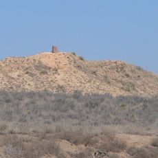
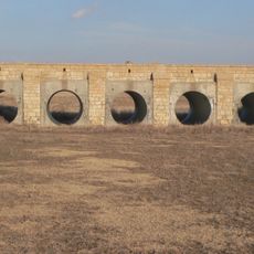
Fort Aubrey, Military fort near Syracuse, Kansas, United States.

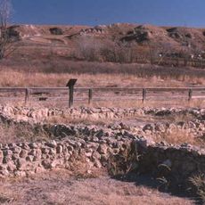
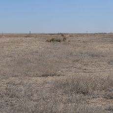
Fort Aubrey was a military outpost located at the head of Spring Creek, roughly 2 miles north of the Arkansas River between Kendall and Syracuse in Hamilton County. Visitors can see three distinct clusters of ground depressions that mark where soldiers lived in partially underground structures during the fort's nine-month period of operation.

The 48th Wisconsin Infantry established the camp in September 1865 in the aftermath of the Civil War, and it was later named after trader Francis Xavier Aubry who had died in Santa Fe. The fort's brief existence of just nine months reflected the temporary nature of many military outposts that were scattered across the frontier and then abandoned.

This site represents a chapter in American military history when the Army pushed westward to secure frontier territories after the Civil War. The soldiers adapted to harsh conditions by building their homes partially underground, a practical solution that shaped how they experienced daily life in this remote landscape.

The site sits about 3 miles east of Syracuse and can be reached via rural roads branching south and east from U.S. Highway 50. It is an open outdoor area with no facilities on-site, so visitors should wear sturdy shoes, bring water, and check with local authorities in advance if there are any access restrictions.

The ground depressions still reveal the outlines of the half-buried shelters that soldiers could dig quickly to shield themselves from the harsh prairie weather. This building method was a practical response to a landscape where wood and stone were scarce resources.

The community of curious travelers

AroundUs brings together thousands of curated places, local tips, and hidden gems, enriched daily by 60,000 contributors worldwide.

Start exploring
Location
GPS coordinates
37.98610,-101.67100
Latest update
December 14, 2025 14:23
Around this place
Lee Richardson Zoo
United States of America

Lee Richardson Zoo

70.1 km
Lake Scott State Park
United States of America

Lake Scott State Park

101.1 km
Point of Rocks
United States of America

Point of Rocks

101 km
Windsor Hotel
United States of America

Windsor Hotel

70 km
Northrup Theater
United States of America

Northrup Theater

7.1 km
Stonington First Methodist-Episcopal Church
United States of America

Stonington First Methodist-Episcopal Church

89.5 km
Prowers Bridge
United States of America

Prowers Bridge

96.9 km
Prowers County Courthouse
United States of America

Prowers County Courthouse

83.9 km
Sen. William H. Thompson House
United States of America

Sen. William H. Thompson House

70.4 km
Indian Mound
United States of America

Indian Mound

30.8 km
Deerfield Texaco Service Station
United States of America

Deerfield Texaco Service Station

47.3 km
Greeley County Courthouse
United States of America

Greeley County Courthouse

54.5 km
Buffalo Hotel
United States of America

Buffalo Hotel

69.9 km
900 Block North Seventh Street Historic District
United States of America

900 Block North Seventh Street Historic District

70.3 km
Morton County WPA Bridge
United States of America

Morton County WPA Bridge

77 km
Cedar Cliff
United States of America

Cedar Cliff

69.7 km
Hope House
United States of America

Hope House

71.2 km
Holly SS Ranch Barn
United States of America

Holly SS Ranch Barn

40.3 km
Douglas Crossing Bridge
United States of America

Douglas Crossing Bridge

55.6 km
Granada Bridge
United States of America

Granada Bridge

57.3 km
Menno Community Hall
United States of America

Menno Community Hall

23.3 km
Finney County Point of Rocks
United States of America

Finney County Point of Rocks

83.5 km
William B. and Julia Washington House
United States of America

William B. and Julia Washington House

61.6 km
Grant County Courthouse District
United States of America

Grant County Courthouse District

53 km
Little Finnup House
United States of America

Little Finnup House

69.7 km
Santa Fe Trail-Kearny County Segment 1
United States of America

Santa Fe Trail-Kearny County Segment 1

42.8 km
Bungalow Historic District
United States of America

Bungalow Historic District

70.6 km
Davies Hotel
United States of America

Davies Hotel

83.9 km
Show the full map
Reviews
Share your experience

No review yet

Discussions
Start a discussion...

No discussion yet

« Fort Aubrey - Military fort near Syracuse, Kansas, United States » is provided by Around Us (aroundus.com). Images and texts are derived from Wikimedia project under a Creative Commons license. You are allowed to copy, distribute, and modify copies of this page, under the conditions set by the license, as long as this note is clearly visible.

Discover hidden gems everywhere you go!

From secret cafés to breathtaking viewpoints, skip the crowded tourist spots and find places that match your style. Our app makes it easy with voice search, smart filtering, route optimization, and insider tips from travelers worldwide. Download now for the complete mobile experience.

Around Us App Screenshot

A unique approach to discovering new places

Le Figaro

All the places worth exploring

France Info

A tailor-made excursion in just a few clicks

20 Minutes

Around Us
Travel Guide & Maps
Download

Send to your phone

QR Code
1

Open the camera app on your mobile.

2

Point at the QR code with your camera. A notification will appear.

3

Tap the notification to open the link.