Enable Location

We need your location to show you interesting places around you

Discover nearby places

Find interesting locations and hidden gems around you

Precise directions

Get accurate directions and distances to places

Your location is never shared with other users. It's only used when you tap the location button.

Indian meridian

Log in to your account

Join the adventure

Create your free account and start exploring (like 60k+ others)

We will send you a code to connect

or
Continue with Google
Continue with Apple
By continuing, you accept our Terms and Conditions and our Privacy Policy

Check your inbox

We've sent a pincode in your inbox. Please enter the code below.

Indian meridian

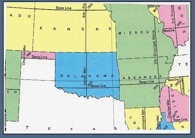
Indian meridian, Principal meridian in Oklahoma, US

Description

The Indian Meridian is a north-south reference line running through Oklahoma at longitude 97 degrees 14 minutes 30 seconds west of Greenwich. It extends from the Red River on the southern border to the Kansas boundary in the north, serving as a crucial reference for land survey work across the state.

History

Surveyors E. N. Darling and Thomas H. Barrett established this meridian in 1870, placing its starting point about one mile south of Fort Arbuckle. The work was part of larger efforts to map the territory and organize land claims following the relocation of tribes to the region.

Culture

The meridian takes its name from the Indian Territory period and reflects how land was reorganized when settlers moved into Oklahoma. People today see this line as a marker of how the region was divided and claimed during a transformative era.

Practical

The meridian itself is not visibly marked on the landscape, as it exists primarily as a survey reference line. The initial point has been preserved and marked, making it a destination for visitors interested in surveying history and land measurement.

Did you know?

The initial point of this meridian was added to the National Register of Historic Places, giving it official status as a historical landmark. This recognition highlights how instrumental the line was in shaping the region's development.

Location
GPS coordinates
34.50680,-97.24750
Latest update
December 11, 2025 11:02

AroundUs brings together thousands of curated places, local tips, and hidden gems, enriched daily by 60,000 contributors worldwide. Discover all places nearby (Oklahoma).

Around this place
Greater Wynnewood Exotic Animal Park
United States of America

Greater Wynnewood Exotic Animal Park

13.6 km
Turner Falls
United States of America

Turner Falls

12.8 km
Turner Falls Park
United States of America

Turner Falls Park

12.4 km
Lake of the Arbuckles
United States of America

Lake of the Arbuckles

21.7 km
Treasure Valley Casino
United States of America

Treasure Valley Casino

6.9 km
Chickasaw Cultural Center
United States of America

Chickasaw Cultural Center

23.1 km
Gold Mountain Casino
United States of America

Gold Mountain Casino

38.1 km
Ada Gaming Center
United States of America

Ada Gaming Center

63 km
Wintersmith Park Historic District
United States of America

Wintersmith Park Historic District

61.1 km
Wanette–Byars Bridge
United States of America

Wanette–Byars Bridge

49.4 km
Chickasaw Nation Capitols
United States of America

Chickasaw Nation Capitols

60.1 km
James C. Nance Memorial Bridge
United States of America

James C. Nance Memorial Bridge

57.3 km
Bethel Missionary Baptist Church
United States of America

Bethel Missionary Baptist Church

19.8 km
Pontotoc County Courthouse
United States of America

Pontotoc County Courthouse

59.9 km
Black Theater of Ardmore
United States of America

Black Theater of Ardmore

39.2 km
Ada Arts and Heritage Center
United States of America

Ada Arts and Heritage Center

60 km
Ardmore Carnegie Library
United States of America

Ardmore Carnegie Library

38.8 km
McClain County Courthouse
United States of America

McClain County Courthouse

57.3 km
Murray County Courthouse
United States of America

Murray County Courthouse

25 km
Garvin County Courthouse
United States of America

Garvin County Courthouse

26.1 km
Travertine Creek
United States of America

Travertine Creek

25.4 km
First National Bank Building
United States of America

First National Bank Building

41.4 km
Travertine Nature Center
United States of America

Travertine Nature Center

27.3 km
Cold Springs Campground Comfort Station #30
United States of America

Cold Springs Campground Comfort Station #30

26.6 km
Bromide Pavilion
United States of America

Bromide Pavilion

24.3 km
Canadian Theater
United States of America

Canadian Theater

57.2 km
Cold Springs Campground
United States of America

Cold Springs Campground

26.6 km
Lake Murray State Park
United States of America

Lake Murray State Park

49.1 km
Show the full map
« Indian meridian - Principal meridian in Oklahoma, US » is provided by Around Us (aroundus.com). Images and texts are derived from Wikimedia project under a Creative Commons license. You are allowed to copy, distribute, and modify copies of this page, under the conditions set by the license, as long as this note is clearly visible.

Discover hidden gems everywhere you go!

From secret cafés to breathtaking viewpoints, skip the crowded tourist spots and find places that match your style. Our app makes it easy with voice search, smart filtering, route optimization, and insider tips from travelers worldwide. Download now for the complete mobile experience.

Around Us App Screenshot

A unique approach to discovering new places

Le Figaro

All the places worth exploring

France Info

A tailor-made excursion in just a few clicks

20 Minutes

Around Us
Travel Guide & Maps
Download

Send to your phone

QR Code
1

Open the camera app on your mobile.

2

Point at the QR code with your camera. A notification will appear.

3

Tap the notification to open the link.