Chest opened
+${chestReward.xp} XP
Explorer
NOUVEAU ×${chestReward.collectible.quantity}
tapez pour fermer
Chest locked

Open chests in the app

Around Us is built for your phone — chests unlock when you walk, explore and capture nearby places.

Enable Location

We need your location to show you interesting places around you

Discover nearby places

Find interesting locations and hidden gems around you

Precise directions

Get accurate directions and distances to places

Your location is never shared with other users. It's only used when you tap the location button.

Log in to your account

Start exploring — it's free

Trusted by 72,891 travelers worldwide

Continue with Google
Continue with Apple
or

We will send you a code to connect

By continuing, you accept our Terms and Conditions and our Privacy Policy

Check your inbox

We've sent a pincode in your inbox. Please enter the code below.

Kiamichi Mountains
Discussion Reviews Photo
12.2k Popularity

Kiamichi Mountains, Mountain range in southeastern Oklahoma, United States.

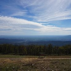
The Kiamichi Mountains spread across Le Flore, Pushmataha, and McCurtain counties with peaks reaching around 2,500 feet. This range sits within the Ouachita National Forest and forms a wooded landscape with valleys and forest cover.

During the 1830s, the United States government relocated the Choctaw Nation to this area, where they built their tribal council house in Tuskahoma. This removal marked a pivotal turning point in the region's story.

These mountains hold deep meaning for the Choctaw people, who named them Nʋnih Chaha Kiamitia in their own language. You can still feel how this land shapes the lives and traditions of those who have called it home for generations.

The area has hundreds of miles of trails for hiking, mountain biking, and horseback riding at various difficulty levels. Good footwear and readiness for changing weather, especially during wetter months, make visits more enjoyable.

The range is home to around 328 vertebrate species, from black bears to cougars and numerous woodpecker varieties. This diversity makes it a place where nature watchers can spot rare animals in their natural habitat.

The community of curious travelers

AroundUs brings together thousands of curated places, local tips, and hidden gems, enriched daily by 60,000 contributors worldwide.

Start exploring
Location
Elevation above the sea
579 m
GPS coordinates
34.60000,-95.00000
Latest update
December 7, 2025 20:46
Around this place
Robbers Cave State Park
United States of America

Robbers Cave State Park

54.6 km
Broken Bow Lake
United States of America

Broken Bow Lake

54.8 km
Beavers Bend Resort Park
United States of America

Beavers Bend Resort Park

59.5 km
Queen Wilhelmina State Park
United States of America

Queen Wilhelmina State Park

58.5 km
Lake Wister
United States of America

Lake Wister

44.8 km
Choctaw Capitol Building
United States of America

Choctaw Capitol Building

25.9 km
Peter Conser House
United States of America

Peter Conser House

39 km
Lake Wister State Park
United States of America

Lake Wister State Park

41.2 km
AT6 Monument
United States of America

AT6 Monument

60 km
Sacred Heart Catholic Church and Rectory
United States of America

Sacred Heart Catholic Church and Rectory

45.4 km
Cole Chapel School
United States of America

Cole Chapel School

60.1 km
Mountain Fork Bridge
United States of America

Mountain Fork Bridge

55.6 km
C.E. Foster House
United States of America

C.E. Foster House

58.2 km
Cupco Church
United States of America

Cupco Church

30.3 km
Trahern's Station
United States of America

Trahern's Station

60.5 km
Ebenezer Monument
United States of America

Ebenezer Monument

69.5 km
Snow School
United States of America

Snow School

44.1 km
Janssen Park
United States of America

Janssen Park

69.7 km
Terry House
United States of America

Terry House

60.9 km
LeFlore County Courthouse
United States of America

LeFlore County Courthouse

61.1 km
Kinta High School
United States of America

Kinta High School

60.6 km
United States of America

Summerfield School

63.6 km
Clayton High School Auditorium
United States of America

Clayton High School Auditorium

32.5 km
Skullyville County Jail
United States of America

Skullyville County Jail

68.9 km
Judge Benjamin Shaver House
United States of America

Judge Benjamin Shaver House

69.2 km
Sebastian County Road 4G Bridge
United States of America

Sebastian County Road 4G Bridge

68.6 km
Bates School
United States of America

Bates School

66.1 km
Beaver's Bend Mining Company
United States of America

Beaver's Bend Mining Company

54.8 km
Show the full map
Reviews
Share your experience

No review yet

Discussions
Start a discussion...

No discussion yet

« Kiamichi Mountains - Mountain range in southeastern Oklahoma, United States » is provided by Around Us (aroundus.com). Images and texts are derived from Wikimedia project under a Creative Commons license. You are allowed to copy, distribute, and modify copies of this page, under the conditions set by the license, as long as this note is clearly visible.

Discover hidden gems everywhere you go!

From secret cafés to breathtaking viewpoints, skip the crowded tourist spots and find places that match your style. Our app makes it easy with voice search, smart filtering, route optimization, and insider tips from travelers worldwide. Download now for the complete mobile experience.

Around Us App Screenshot

A unique approach to discovering new places

Le Figaro

All the places worth exploring

France Info

A tailor-made excursion in just a few clicks

20 Minutes

Around Us
Travel Guide & Maps
Download

Send to your phone

QR Code
1

Open the camera app on your mobile.

2

Point at the QR code with your camera. A notification will appear.

3

Tap the notification to open the link.