Chest opened
+${chestReward.xp} XP
Explorer
NOUVEAU ×${chestReward.collectible.quantity}
tapez pour fermer
Chest locked

Open chests in the app

Around Us is built for your phone — chests unlock when you walk, explore and capture nearby places.

Enable Location

We need your location to show you interesting places around you

Discover nearby places

Find interesting locations and hidden gems around you

Precise directions

Get accurate directions and distances to places

Your location is never shared with other users. It's only used when you tap the location button.

Log in to your account

Start exploring — it's free

Trusted by 72,877 travelers worldwide

Continue with Google
Continue with Apple
or

We will send you a code to connect

By continuing, you accept our Terms and Conditions and our Privacy Policy

Check your inbox

We've sent a pincode in your inbox. Please enter the code below.

Adair State Park
Discussion Reviews Photo
1.3k Popularity

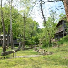
Adair State Park, State park in Stilwell, Oklahoma.

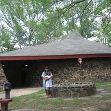
Adair State Park is a recreational area spanning 25 acres with a 15-acre fishing pond, camping zones, and sheltered pavilions for groups. The grounds are laid out to accommodate both water activities and overnight stays.

The park originated as a state facility but shifted to county management in September 2011 when financial constraints forced closure announcements. This administrative transition marked a turning point in its operation.

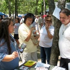
The park serves as a gathering place where local families come together for fishing trips, camping stays, and holiday celebrations. This role as a community meeting point shapes how neighbors experience outdoor time together.

Access to the park comes through Highway 51 East with seven RV sites offering electric and water hookups alongside twenty primitive camping spots. All facilities remain accessible to visitors throughout the year.

The grounds feature an ADA-compliant pull-through RV site, a detail that sets it apart from many similar parks. Around-the-clock access to restrooms with shower facilities makes overnight camping more comfortable for visitors with accessibility needs.

The community of curious travelers

AroundUs brings together thousands of curated places, local tips, and hidden gems, enriched daily by 60,000 contributors worldwide.

Start exploring
Location
GPS coordinates
35.83120,-94.62500
Latest update
December 14, 2025 18:08
Around this place
Cherokee National Capitol
United States of America

Cherokee National Capitol

32.5 km
Cherokee Heritage Center
United States of America

Cherokee Heritage Center

30.1 km
Cherokee National Holiday
United States of America

Cherokee National Holiday

32.5 km
Cherokee Female Seminary
United States of America

Cherokee Female Seminary

32.7 km
Murrell Home
United States of America

Murrell Home

30.3 km
Cane Hill College
United States of America

Cane Hill College

22.4 km
Golda's Mill
United States of America

Golda's Mill

13 km
Cherokee National Jail
United States of America

Cherokee National Jail

32.2 km
Gypsy Camp Historic District
United States of America

Gypsy Camp Historic District

32.3 km
Adair County Courthouse
United States of America

Adair County Courthouse

1.9 km
Lee Creek Bridge
United States of America

Lee Creek Bridge

29.4 km
Twin Bridges Historic District
United States of America

Twin Bridges Historic District

16.3 km
Earle House
United States of America

Earle House

22.2 km
American Legion Hut
United States of America

American Legion Hut

32.2 km
United States of America

Opera Block

18.7 km
Cane Hill Battlefield
United States of America

Cane Hill Battlefield

22.8 km
Cane Hill Cemetery
United States of America

Cane Hill Cemetery

22.4 km
Willis Noll House
United States of America

Willis Noll House

31 km
Blackburn House
United States of America

Blackburn House

22.4 km
D.N. Edmiston House
United States of America

D.N. Edmiston House

22.5 km
John Edmiston House
United States of America

John Edmiston House

22.6 km
John Tilley House
United States of America

John Tilley House

28.1 km
Evansville-Dutch Mills Road Bridge
United States of America

Evansville-Dutch Mills Road Bridge

11.9 km
United Presbyterian Church of Canehill
United States of America

United Presbyterian Church of Canehill

22.4 km
Slack-Comstock-Marshall Farm
United States of America

Slack-Comstock-Marshall Farm

31.2 km
Zeb Edmiston House
United States of America

Zeb Edmiston House

22.4 km
Rennic Road Bridge
United States of America

Rennic Road Bridge

29.9 km
Methodist Manse
United States of America

Methodist Manse

22.3 km
Show the full map
Reviews
Share your experience

No review yet

Discussions
Start a discussion...

No discussion yet

« Adair State Park - State park in Stilwell, Oklahoma » is provided by Around Us (aroundus.com). Images and texts are derived from Wikimedia project under a Creative Commons license. You are allowed to copy, distribute, and modify copies of this page, under the conditions set by the license, as long as this note is clearly visible.

Discover hidden gems everywhere you go!

From secret cafés to breathtaking viewpoints, skip the crowded tourist spots and find places that match your style. Our app makes it easy with voice search, smart filtering, route optimization, and insider tips from travelers worldwide. Download now for the complete mobile experience.

Around Us App Screenshot

A unique approach to discovering new places

Le Figaro

All the places worth exploring

France Info

A tailor-made excursion in just a few clicks

20 Minutes

Around Us
Travel Guide & Maps
Download

Send to your phone

QR Code
1

Open the camera app on your mobile.

2

Point at the QR code with your camera. A notification will appear.

3

Tap the notification to open the link.