Chouteau Lock & Dam

Log in to your account

AroundUs is a community-driven map of interesting places, built by curious explorers like you. It grows with every review, story, and photo you share.
Connect to save your favorite spots, contribute locations, and create personalized routes.
Continue with Google
Continue with Apple
Continue with X
Continue with Facebook
Continue with email
By continuing, you accept our Terms and Conditions and our Privacy Policy
Create an account

Chouteau Lock & Dam

Add to collection
Map
Suggest a change
Share

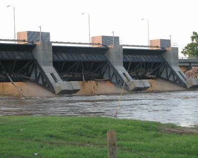
Chouteau Lock & Dam, Navigation lock and dam system on Arkansas River, Wagoner County, United States.

Chouteau Lock and Dam is a navigation facility on the Verdigris River near the Three Forks junction in Oklahoma. It combines an earth gravity dam with a lock structure designed to manage water flow and allow river traffic to pass through.

Construction of this facility began in the 1960s and was completed in the early 1970s as part of the McClellan-Kerr Navigation System. The project aimed to improve river transportation and water management in the region.

The facility represents part of Oklahoma's industrial heritage as the seventeenth lock and dam of the McClellan-Kerr Arkansas River Navigation System.

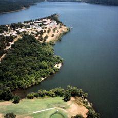
The site borders multiple recreation areas offering camping and day-use facilities for visitors. Plan your visit during warmer months when water conditions and outdoor access are at their best.

The reservoir extends 18.7 miles upstream, covering 2,270 acres with a capacity of 23,340 acre-feet and a maximum discharge rate of 155,000 cubic feet per second.

Location: Wagoner County

GPS coordinates: 35.85833,-95.37194

Latest update: December 14, 2025 16:42

Photos
Around this place
USS Batfish
United States of America

USS Batfish

9 km
Fort Gibson
United States of America

Fort Gibson

12 km
Sequoyah State Park
United States of America

Sequoyah State Park

12.8 km
Monastery of Our Lady of the Annunciation of Clear Creek
United States of America

Monastery of Our Lady of the Annunciation of Clear Creek

25.2 km
Fort Gibson Dam
United States of America

Fort Gibson Dam

12.8 km
Fort Gibson National Cemetery
United States of America

Fort Gibson National Cemetery

14.2 km
Five Civilized Tribes Museum
United States of America

Five Civilized Tribes Museum

11.2 km
Manhattan Building
United States of America

Manhattan Building

12.1 km
A.W. Patterson House
United States of America

A.W. Patterson House

11.7 km
Grant Foreman House
United States of America

Grant Foreman House

11.8 km
First Baptist Church
United States of America

First Baptist Church

11.8 km
Commandant's Quarters
United States of America

Commandant's Quarters

12.1 km
Ward Chapel AME Church
United States of America

Ward Chapel AME Church

11.6 km
Wagoner Armory
United States of America

Wagoner Armory

11.3 km
Surety Building
United States of America

Surety Building

12.2 km
Frederick Parkinson House
United States of America

Frederick Parkinson House

11.7 km
John W. Gibson House
United States of America

John W. Gibson House

10.9 km
Railway Exchange Building
United States of America

Railway Exchange Building

12.1 km
St. Thomas Primitive Baptist Church
United States of America

St. Thomas Primitive Baptist Church

21.6 km
St. James Episcopal Church
United States of America

St. James Episcopal Church

11.1 km
A. C. Trumbo House
United States of America

A. C. Trumbo House

11.7 km
V. R. Coss House
United States of America

V. R. Coss House

11.8 km
Ed Edmondson United States Courthouse
United States of America

Ed Edmondson United States Courthouse

12.1 km
Central Baptist Church
United States of America

Central Baptist Church

11.7 km
United States of America

Hotel Muskogee

12.2 km
Collin McKinney House
United States of America

Collin McKinney House

10.4 km
Fort Gibson State Historic Site
United States of America

Fort Gibson State Historic Site

12 km
Oklahoma Music Hall of Fame
United States of America

Oklahoma Music Hall of Fame

12.5 km
Show the full map
Reviews

Visited this place? Tap the stars to rate it and share your experience / photos with the community! Try now! You can cancel it anytime.

« Chouteau Lock & Dam - Navigation lock and dam system on Arkansas River, Wagoner County, United States » is provided by Around Us (aroundus.com). Images and texts are derived from Wikimedia project under a Creative Commons license. You are allowed to copy, distribute, and modify copies of this page, under the conditions set by the license, as long as this note is clearly visible.

Discover hidden gems everywhere you go!

From secret cafés to breathtaking viewpoints, skip the crowded tourist spots and find places that match your style. Our app makes it easy with voice search, smart filtering, route optimization, and insider tips from travelers worldwide. Download now for the complete mobile experience.

Around Us App Screenshot

A unique approach to discovering new places

Le Figaro

All the places worth exploring

France Info

A tailor-made excursion in just a few clicks

20 Minutes