Enable Location

We need your location to show you interesting places around you

Discover nearby places

Find interesting locations and hidden gems around you

Precise directions

Get accurate directions and distances to places

Your location is never shared with other users. It's only used when you tap the location button.

OKARMO Corner

Log in to your account

Start exploring — it's free

Trusted by 62,526 travelers worldwide

Continue with Google
Continue with Apple
or

We will send you a code to connect

By continuing, you accept our Terms and Conditions and our Privacy Policy

Check your inbox

We've sent a pincode in your inbox. Please enter the code below.

OKARMO Corner

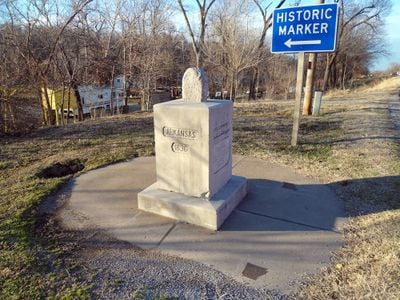
OKARMO Corner, monument showing the tripoint of Oklahoma, Arkansas and Missouri

OKARMO Corner is a monument near Southwest City, Missouri, marking where the borders of Arkansas, Oklahoma, and Missouri meet. The site consists of stacked stones added over time: an original boundary stone from the 1820s at the top, a marble pedestal added in 1915, and a concrete circle with carved lines at the base.

The original boundary stone dates to the 1820s and marked the Arkansas-Missouri border following the Missouri Compromise of 1820. In 1915, the Ozark Culture Club built a marble pedestal to protect the aged stone and inscribed it with the years each state joined the Union.

The name OKARMO combines the initials of the three states: Oklahoma, Arkansas, and Missouri. Visitors can stand at one spot and experience being in three states simultaneously, creating a direct connection to how state boundaries shape the land.

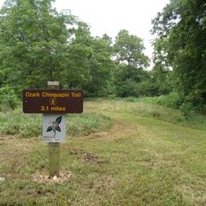
The monument sits along Missouri Route 43, about one mile south of Southwest City, and is free to visit year-round. Visitors can park at paved road shoulders and should watch for traffic when crossing the road and exploring the area.

A local farmer rediscovered the lost boundary stone from the 1820s and brought it to community attention, leading to its preservation and protection. This recovered stone now crowns the monument and links early land survey history with grassroots efforts to preserve it.

The community of curious travelers

AroundUs brings together thousands of curated places, local tips, and hidden gems, enriched daily by 60,000 contributors worldwide.

Start exploring
Part of
municipal boundary
GPS coordinates
36.49950,-94.61788
Latest update
February 9, 2026 07:40
Around this place
Grand Lake o' the Cherokees
United States of America

Grand Lake o' the Cherokees

23.6 km
Old Spanish Treasure Cave
United States of America

Old Spanish Treasure Cave

14.2 km
Lake Eucha
United States of America

Lake Eucha

27.7 km
Lake Windsor
United States of America

Lake Windsor

32.1 km
Big Sugar Creek State Park
United States of America

Big Sugar Creek State Park

32 km
Jacobs Cavern
United States of America

Jacobs Cavern

26.8 km
Ozark Plateau National Wildlife Refuge
United States of America

Ozark Plateau National Wildlife Refuge

21.8 km
Splitlog Church
United States of America

Splitlog Church

15.9 km
Old McDonald County Courthouse
United States of America

Old McDonald County Courthouse

23.4 km
Bluff Dwellers Cave
United States of America

Bluff Dwellers Cave

11.9 km
Kindley House
United States of America

Kindley House

17.7 km
Carl House
United States of America

Carl House

28.5 km
Wee Pine Knot
United States of America

Wee Pine Knot

14 km
Coon Creek Bridge
United States of America

Coon Creek Bridge

20.5 km
Kansas City Southern Railway Locomotive No. 73D and Caboose No. 385
United States of America

Kansas City Southern Railway Locomotive No. 73D and Caboose No. 385

22.9 km
Wasson House
United States of America

Wasson House

31.7 km
Railroad Cottage
United States of America

Railroad Cottage

28.1 km
Shiloh House
United States of America

Shiloh House

14.9 km
Bolin Barn and Smokehouse
United States of America

Bolin Barn and Smokehouse

23.6 km
Sulphur Springs Park Reserve
United States of America

Sulphur Springs Park Reserve

14.6 km
Kansas City Southern Railway Caboose No. 383
United States of America

Kansas City Southern Railway Caboose No. 383

17.1 km
Banks House
United States of America

Banks House

25.4 km
Adar House
United States of America

Adar House

12.8 km
Mitchell House
United States of America

Mitchell House

28.4 km
Sulphur Springs Old School Complex Historic District
United States of America

Sulphur Springs Old School Complex Historic District

14.2 km
Mitchell-Ward House
United States of America

Mitchell-Ward House

28.1 km
Jones House
United States of America

Jones House

14.3 km
Gentry Public Library
United States of America

Gentry Public Library

28.5 km
Show the full map
« OKARMO Corner - monument showing the tripoint of Oklahoma, Arkansas and Missouri » is provided by Around Us (aroundus.com). Images and texts are derived from Wikimedia project under a Creative Commons license. You are allowed to copy, distribute, and modify copies of this page, under the conditions set by the license, as long as this note is clearly visible.

Discover hidden gems everywhere you go!

From secret cafés to breathtaking viewpoints, skip the crowded tourist spots and find places that match your style. Our app makes it easy with voice search, smart filtering, route optimization, and insider tips from travelers worldwide. Download now for the complete mobile experience.

Around Us App Screenshot

A unique approach to discovering new places

Le Figaro

All the places worth exploring

France Info

A tailor-made excursion in just a few clicks

20 Minutes

Around Us
Travel Guide & Maps
Download

Send to your phone

QR Code
1

Open the camera app on your mobile.

2

Point at the QR code with your camera. A notification will appear.

3

Tap the notification to open the link.