Enable Location

We need your location to show you interesting places around you

Discover nearby places

Find interesting locations and hidden gems around you

Precise directions

Get accurate directions and distances to places

Your location is never shared with other users. It's only used when you tap the location button.

Buntu Rantemario

Log in to your account

Start exploring — it's free

Trusted by 65,545 travelers worldwide

Continue with Google
Continue with Apple
or

We will send you a code to connect

By continuing, you accept our Terms and Conditions and our Privacy Policy

Check your inbox

We've sent a pincode in your inbox. Please enter the code below.

Buntu Rantemario
Discussion Reviews 1 Photos
10.2k Popularity

Buntu Rantemario, Mountain summit in South Sulawesi, Indonesia.

Buntu Rantemario is the highest summit of the Latimojong range in Tana Toraja, South Sulawesi, Indonesia, sitting at around 3,478 meters (11,410 feet) above sea level. It rises through forested highland terrain crossed by several climbing routes that link a number of basecamp locations.

Climbing routes to Buntu Rantemario were first documented in the late 20th century, when mountaineers began mapping systematic paths to the top. Eight official staging areas were later established along these routes, shaping the way climbers organize their ascent today.

The mountain sits within lands connected to the Toraja people, who continue their traditional ways in surrounding villages. Local communities view this highland region as integral to their cultural identity and daily connection to the land.

The climb starts from Karangan village, where marked trails lead up the mountain. Water sources are available at set rest points along the way, so carrying a refillable container makes the ascent more manageable.

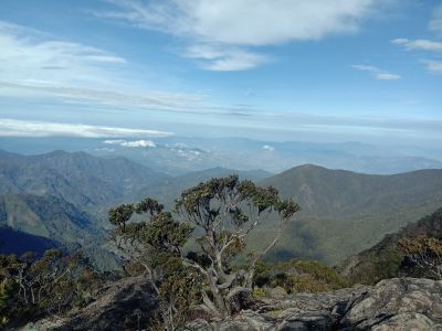
The area near the summit is covered with moss-laden trees that grow in this highland climate, giving the top a distinctly different look from the forested slopes below. On clear days, the coastlines of both South and West Sulawesi are visible from here.

The community of curious travelers

AroundUs brings together thousands of curated places, local tips, and hidden gems, enriched daily by 60,000 contributors worldwide.

Start exploring
Location
Address
Mount Latimojong, To'lajuk, Latimojong, Luwu Regency, South Sulawesi, Indonesia
GPS coordinates
-3.38489,120.02425
Latest update
March 3, 2026 08:21
Reviews
Share your experience

No review yet

Discussions
Start a discussion...

No discussion yet

« Buntu Rantemario - Mountain summit in South Sulawesi, Indonesia » is provided by Around Us (aroundus.com). Images and texts are derived from Wikimedia project under a Creative Commons license. You are allowed to copy, distribute, and modify copies of this page, under the conditions set by the license, as long as this note is clearly visible.

Discover hidden gems everywhere you go!

From secret cafés to breathtaking viewpoints, skip the crowded tourist spots and find places that match your style. Our app makes it easy with voice search, smart filtering, route optimization, and insider tips from travelers worldwide. Download now for the complete mobile experience.

Around Us App Screenshot

A unique approach to discovering new places

Le Figaro

All the places worth exploring

France Info

A tailor-made excursion in just a few clicks

20 Minutes

Around Us
Travel Guide & Maps
Download

Send to your phone

QR Code
1

Open the camera app on your mobile.

2

Point at the QR code with your camera. A notification will appear.

3

Tap the notification to open the link.