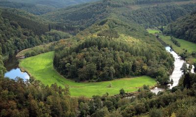
Tombeau du Géant, River meander in Bouillon, Belgium
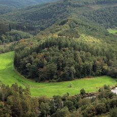
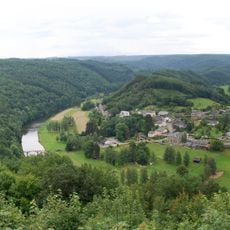
The Semois River forms a horseshoe-shaped curve at this protected natural site, stretching over 5 kilometers through steep forested hills along limestone cliffs.
The observation point marks a historical route used by German armies during both World Wars, with traces of fortifications still visible near the summit.
Local legends tell of a Treverian giant who leaped from the Gattes Rock to avoid Roman capture, giving the location its name Tombeau du Géant.
Visitors can reach multiple observation platforms through marked hiking trails connecting the villages of Rochehaut, Botassart, and Corbion throughout the year.
The natural limestone formation creates optical effects where the river appears to form a perfect coffin shape when viewed from specific angles.
Location: Bouillon
GPS coordinates: 49.81378,5.04224
Latest update: May 27, 2025 17:42
Belgium preserves numerous historical sites and natural areas that remain outside the usual tourist circuits. The country contains medieval fortifications, castles from various periods, and protected areas that provide insight into its military and cultural past. The Hallerbos forest transforms into a blue carpet of Atlantic bluebells each spring. Fort Eben-Emael, once considered impregnable, documents 20th-century military architecture. The prehistoric flint mines of Spiennes, a UNESCO World Heritage site, testify to 6,000 years of mining history. These locations combine natural heritage with historical evidence and offer visitors the opportunity to discover lesser-known aspects of Belgium.
Chateau des Amerois
10.7 km
Château de Sedan
14.1 km
Bouillon Castle
2.9 km
Château d'Olly
9 km
Abbey of Cordemois
2 km
Vallée de la Semois National Park
13.9 km
Église Saint-Firmin de Rochehaut
4 km
Chapelle du Flachis
12.6 km
Pont Saint-Lambert
9.9 km
Église de Floing
13.1 km
Forges
12.3 km
Chapelle Saint-Roch de Paliseul
12.3 km
Chapelle Saint-Monon de Cornimont
6.3 km
Saint-Agatha church
9.7 km
Église Notre-Dame de Fleigneux
10 km
Église Saint-Remi de Givonne
11 km
Église Saint-Martin d'Iges
13.3 km
Saint Hubertus church of Mortehan
12.2 km
Église Saint-Charles de Bosseval-et-Briancourt
13.7 km
Église Saint-Pierre d'Illy
10.5 km
Église Saint-Remi de Rubécourt-et-Lamécourt
13.9 km
Église Saint-Étienne de Fond de Givonne
13.6 km
Église Saint-Memmie de Saint-Menges
11.8 km
Église Saint-Mathieu de La Chapelle
8.3 km
Château d'Olly
9 km
Chapelle de l'hôpital de Sedan
14.1 km
Chapelle Notre-Dame-de-la-Consolation de Floing
13.5 km
Meander of the Semois river at Frahan
4 kmReviews
Visited this place? Tap the stars to rate it and share your experience / photos with the community! Try now! You can cancel it anytime.
Discover hidden gems everywhere you go!
From secret cafés to breathtaking viewpoints, skip the crowded tourist spots and find places that match your style. Our app makes it easy with voice search, smart filtering, route optimization, and insider tips from travelers worldwide. Download now for the complete mobile experience.
A unique approach to discovering new places❞
— Le Figaro
All the places worth exploring❞
— France Info
A tailor-made excursion in just a few clicks❞
— 20 Minutes