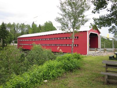
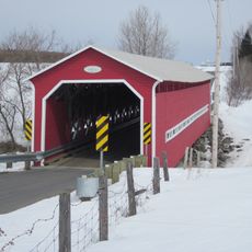
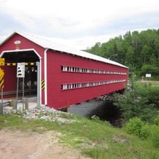
Ducharme Bridge, Wooden covered bridge in La Bostonnais, Canada.
The Ducharme Bridge is a wooden covered structure built with a traditional lattice truss design that crosses the Bostonnais River. It is constructed entirely from spruce wood and features the characteristic enclosed design typical of covered bridges.
The bridge was built between 1945 and 1946, with its official opening taking place in 1948 following the local need for a river crossing. It represents a period when wooden covered bridges were still important infrastructure for communities.
The bridge takes its name from Romulus Ducharme, a local politician who served in the Legislative Assembly representing the Laviolette district. This naming reflects how the community honored figures who shaped the region.
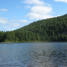
The bridge is located on Rue de l'Église in La Bostonnais and serves as a direct crossing over the river for both vehicles and pedestrians. The surrounding area is quiet and rural, making it easy to access and explore at a leisurely pace.
This bridge represents one of the final examples of a bridge engineering method developed by Quebec's Department of Colonization in the early 20th century. Such wooden structures were gradually replaced by modern construction techniques, making them uncommon sights today.
Location: La Bostonnais
Official opening: 1948
Length: 41.76 m
Width: 6.55 m
Made from material: wood
GPS coordinates: 47.51972,-72.68083
Latest update: December 14, 2025 17:01
La Mauricie National Park
83 km
Laurentides Wildlife Reserve
54.5 km
Saint-Jean-des-Piles
92.5 km
Zec du Chapeau-de-Paille
85 km
Seigneurie de Batiscan
85.8 km
Saint-Maurice Wildlife Reserve
64.9 km
Portneuf Regional Natural Park
87.3 km
Reservoir Blanc
47.2 km
Bordeleau Bridge
94.7 km
Zec de la Lièvre
92.5 km
Tavibois
89.7 km
Camp Val Notre-Dame
90.9 km
Irénée-Marie Ecological Reserve
84.1 km
Église Saint-Andrew
12.2 km
Calvaire du rang Saint-Joseph
88 km
Pont Thiffault
5.8 km
Ancien couvent de Saint-Léonard
91.3 km
Caserne Patrick-Douville
89.3 km
Réserve de biodiversité projetée de la Vallée-Tousignant
64.9 km
Church of St. Bernardine of Siena
69.4 km
Église Saint-Zéphirin
11.7 km
Chapelle Saint-Agricole de Saint-Raymond
83.4 km
Chapelle du cimetière de Saint-Raymond
94.3 km
Noyau religieux de Saint-Léonard-de-Portneuf
91.3 km
Église de Saint-Ubalde
90.5 km
Édifice du Brown Community Club
11.8 km
Rocher Steamboat
60.9 km
Pointe à la Mine
89.1 kmVisited this place? Tap the stars to rate it and share your experience / photos with the community! Try now! You can cancel it anytime.
Discover hidden gems everywhere you go!
From secret cafés to breathtaking viewpoints, skip the crowded tourist spots and find places that match your style. Our app makes it easy with voice search, smart filtering, route optimization, and insider tips from travelers worldwide. Download now for the complete mobile experience.
A unique approach to discovering new places❞
— Le Figaro
All the places worth exploring❞
— France Info
A tailor-made excursion in just a few clicks❞
— 20 Minutes