West Hants Regional Municipality
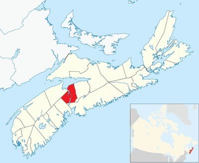
West Hants Regional Municipality, regional municipality in Nova Scotia, Canada
Location: Hants County
Shares border with: Kings County
Website: https://westhants.ca/#
GPS coordinates: 44.96670,-64.10000
Latest update: March 8, 2025 00:19
Minas Basin
32 km
Fort Edward
4.1 km
Grand-Pré National Historic Site
22.9 km
RCAF Station Beaverbank
30.1 km
Blomidon Provincial Park
38.4 km
Raymond Field
25.2 km
Fort Vieux Logis
4.1 km
Churchill House
12.5 km
Prescott House Museum
27.2 km
Uniacke Estate Museum Park
21.4 km
Charles Macdonald Concrete House Museum
37.7 km
Atlantic Food and Horticulture Research Centre
31.9 km
Kings County Museum
33.4 km
Hants Exhibition Arena
3 km
Haliburton House Museum
4.1 km
Covenanter Church
21.9 km
Shand House Museum
4.4 km
Boot Island National Wildlife Area
23.7 km
Coldbrook Provincial Park
38.9 km
Medford Beach
31.5 km
Blomidon Lookoff Provincial Park
35.5 km
Cape Split Provincial Park
46.6 km
Horton Bluff front range light
18.6 km
Ottawa House
48.9 km
Fort Edward Blockhouse
4.3 km
Convocation Hall
3.3 km
Chase House
25.5 km
Grand-Pré Memorial Chapel
23.1 kmVisited this place? Tap the stars to rate it and share your experience / photos with the community! Try now! You can cancel it anytime.
Discover hidden gems everywhere you go!
From secret cafés to breathtaking viewpoints, skip the crowded tourist spots and find places that match your style. Our app makes it easy with voice search, smart filtering, route optimization, and insider tips from travelers worldwide. Download now for the complete mobile experience.
A unique approach to discovering new places❞
— Le Figaro
All the places worth exploring❞
— France Info
A tailor-made excursion in just a few clicks❞
— 20 Minutes