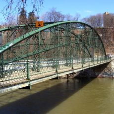
Blackfriars Street Bridge, Wrought iron bowstring arch bridge in London, Canada
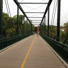
Blackfriars Street Bridge is a pedestrian and cycling crossing made of wrought iron with a bow-shaped arch design that spans the North Thames River in London, Ontario and connects Blackfriars Street to Ridout Street North. Its arched structure with original metal lattice girders carries foot traffic, bicycles, and vehicles across the river.
The bridge was built in 1875 by the Wrought Iron Bridge Company from Canton, Ohio and replaced several wooden structures that had existed at the site since 1831. It therefore stands at a location that has served as an important river crossing for nearly two centuries.
The bridge structure inspired local artist Ted Goodden to create a series of stained glass windows titled '12 Views of Blackfriars Bridge'. This artistic response shows how the structure continues to influence the local creative community.
Following extensive restoration work completed in 2017, the bridge reopened in December 2018 and now carries pedestrian, cyclist, and vehicle traffic regularly. Visitors should expect a narrow crossing, especially during times when multiple users are present.
This structure holds the distinction of being North America's oldest wrought iron bridge still carrying vehicle traffic while maintaining its original pin connections and lattice girders. The preservation of these original engineering details demonstrates how the structure has retained its functionality over nearly 150 years.
Location: Ontario
GPS coordinates: 42.98890,-81.25710
Latest update: December 10, 2025 20:08
Labatt Park
602 m
Victoria Park
669 m
One London Place
926 m
Grand Theatre
592 m
Eldon House
472 m
City Centre Towers
926 m
Middlesex County Court House
789 m
London Hydro Substation No. 4
730 m
Centennial Hall
851 m
First Christian Reformed Church
358 m
260 Sydenham Street
995 m
Plan of the Town of London, CW, Published by The Craig, London, 1846
1.1 km
Map of the Township of London, Canada West, 1863
1.1 km
Ridout Street Complex
609 m
1 Dundas Street
796 m
Plan (in pencil) of property in the Village of Petersville
584 m
Map of the city of London, surveyed and drawn by Sam'l Peters, P.L.S., published by Geo. Railton, for the London Directory, 1856
1.1 km
350 Talbot Street
977 m
London, Canada West, 1840-1841
1.1 km
308 Princess Avenue
947 m
Plan of Building Lots, The Property of Colonel Askin, on the north side of Oxford Street, in the town of London C.W.
836 m
London and Western Trusts Building
1 km
King Street Bridge
944 m
165 Oxford Street East
648 m
London Mechanics' Institute
984 m
Blackfriars Bridge
13 m
Proposed Route of the West Ontario Pacific Railroad through the City of London
880 m
85 Albion Street
360 mVisited this place? Tap the stars to rate it and share your experience / photos with the community! Try now! You can cancel it anytime.
Discover hidden gems everywhere you go!
From secret cafés to breathtaking viewpoints, skip the crowded tourist spots and find places that match your style. Our app makes it easy with voice search, smart filtering, route optimization, and insider tips from travelers worldwide. Download now for the complete mobile experience.
A unique approach to discovering new places❞
— Le Figaro
All the places worth exploring❞
— France Info
A tailor-made excursion in just a few clicks❞
— 20 Minutes