Middlesex County Court House
Middlesex County Court House, Historic courthouse in London, Canada.
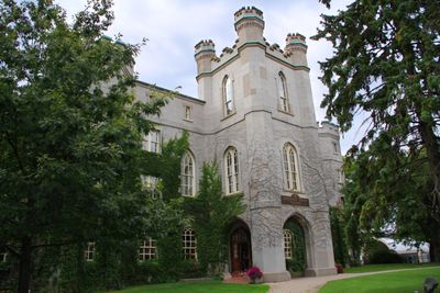
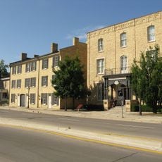
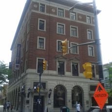
Middlesex County Court House is a courthouse in London, Ontario, built between 1827 and 1829 from locally quarried stone with a central tower, corner octagons, and pointed-arch windows. It occupies 4 acres of land between Dundas Street and King Street in downtown, where its distinctive architectural features shape the urban landscape.
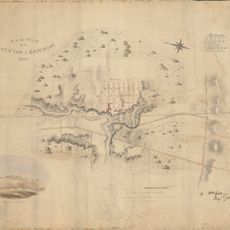
The building was constructed after Lieutenant-Governor John Graves Simcoe had initially considered this location as a potential provincial capital before Toronto was selected for Ontario's government. This early focus shows the place's importance in Ontario's settlement story.
The courthouse displays Gothic Revival details with exposed timber ceilings in the courtroom and distinctive crenellations that reflect how early Canadian institutions were built. These design choices shaped how such public spaces looked and felt in the 19th century.
The courthouse sits on a large property in downtown between two main streets, making it easy to find and approach. Plan to visit on weekdays when the building functions as an active court, and check whether tours are possible outside regular business hours.
The building gained protection through three separate designations: National Historic Site status, Ontario Heritage Trust easement, and municipal heritage recognition. This triple acknowledgment shows how it is viewed as important across different levels.
Location: London
Inception: 1829
Part of: Downtown Heritage Conservation District
Address: 399 Ridout Street North
GPS coordinates: 42.98211,-81.25435
Latest update: December 13, 2025 11:47
Labatt Park
390 m
One London Place
747 m
Blackfriars Street Bridge
789 m
Grand Theatre
498 m
Eldon House
316 m
City Centre Towers
747 m
London Regional Children's Museum
773 m
London Hydro Substation No. 4
285 m
Plan of laying out the ground of Publick Square, London
802 m
First Christian Reformed Church
492 m
Plan of the Town of London, CW, Published by The Craig, London, 1846
802 m
Map of the city of London, surveyed and drawn by Sam'l Peters, P.L.S., published by Geo. Railton, for the London Directory, 1856
802 m
Sketch of part of the London Township
802 m
Plan of London shewing the gas lamps
802 m
Ridout Street Complex
180 m
1 Dundas Street
127 m
350 Talbot Street
302 m
37 Ridout Street South
779 m
330 Clarence Street
669 m
Map of the Township of London, Canada West, 1863
802 m
London, Canada West, 1840-1841
802 m
King Street Bridge
265 m
London and Western Trusts Building
425 m
London Mechanics' Institute
657 m
Blackfriars Bridge
799 m
The Site of London
802 m
Sketch of the position of London, U.C. Nov'r 1839
802 m
Former Toronto Dominion Bank Building
774 mVisited this place? Tap the stars to rate it and share your experience / photos with the community! Try now! You can cancel it anytime.
Discover hidden gems everywhere you go!
From secret cafés to breathtaking viewpoints, skip the crowded tourist spots and find places that match your style. Our app makes it easy with voice search, smart filtering, route optimization, and insider tips from travelers worldwide. Download now for the complete mobile experience.
A unique approach to discovering new places❞
— Le Figaro
All the places worth exploring❞
— France Info
A tailor-made excursion in just a few clicks❞
— 20 Minutes