Nümbrecht, Climatic health resort in Oberbergischer Kreis, Germany
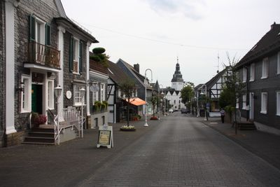
Nümbrecht is a health resort in the Oberbergischer Kreis region of North Rhine-Westphalia, surrounded by extensive forests and walking paths. Situated at about 298 meters elevation, it offers over 300 kilometers of well-developed walking routes that wind through the countryside.
The location was first documented in 1131 as part of a papal possession confirmation record related to the Bonn Saint Cassius monastery. Archaeological evidence shows settlements existed here since the Stone Age.
The community hosts annual September potato festivals that celebrate local farming traditions and bring together residents and visitors. These celebrations reflect how people here maintain a connection to the agricultural past that shaped the region.
The Parkhotel on Parkstraße 3 provides accommodation and wellness facilities including a sauna and swimming pool. The many walking routes here range in difficulty, so visitors can choose paths suited to their fitness level.
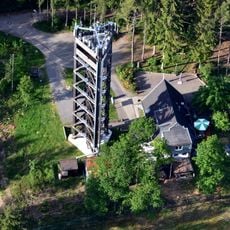
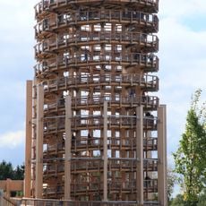
A watchower about 30 meters tall lets visitors look far across the landscape to spot river valleys and mountain ranges. This vantage point offers an unexpected perspective across the otherwise forested hillsides of the area.
Location: Oberbergischer Kreis
Location: Cologne Government Region
Elevation above the sea: 298 m
Shares border with: Engelskirchen, Wiehl
Website: https://nuembrecht.de
GPS coordinates: 50.90528,7.54222
Latest update: December 20, 2025 02:14
Panarbora Park
6.8 km
Homburg Castle
1.2 km
Wiehler Tropfsteinhöhle
3.7 km
Burg Bieberstein
6 km
Kirche Nümbrecht
382 m
Stauweiher Bieberstein
6.4 km
Saint Michael Church
6.1 km
Holsteins Mühle
1.7 km
Evangelische Kirche Waldbröl
6.2 km
Burg Bellinghausen
3.7 kmBurg Isengarten
5.7 km
Hl. Geist Kirche
129 m
St. Hubertus (Grötzenberg)
3.6 kmLaubwaldkomplex Starksfeld und Rennbahnsköpfchen
1.4 kmLaubwaldkomplex In den Eichen
4 km
Aussichtsturm Auf dem Lindchen
910 m
Scenic viewpoint
7 kmLSG-Nuembrecht, Waldbroel
1.2 kmLaubwald mit Quellrinnen südlich Schloss Homb
1 kmFeuchtgebiet Harscheider Bach-Tal bei Geringhauser Mühle
2.9 kmWesterbachtal
7.1 kmWiehltalaue Oberwiehl-Bieberstein
5.2 kmBrölbach-Aue Grosse Wiese und Dicksteinswiese
1.6 km
Evangelische Kirche Marienberghausen
3.7 kmBrölbach-Aue Auf dem Auel bei Hombrug-Bröl
1.6 kmHillenbach-Tal
2.2 kmBieberstein-Steinbreche
6.2 km
Panarbora tower
6.8 kmVisited this place? Tap the stars to rate it and share your experience / photos with the community! Try now! You can cancel it anytime.
Discover hidden gems everywhere you go!
From secret cafés to breathtaking viewpoints, skip the crowded tourist spots and find places that match your style. Our app makes it easy with voice search, smart filtering, route optimization, and insider tips from travelers worldwide. Download now for the complete mobile experience.
A unique approach to discovering new places❞
— Le Figaro
All the places worth exploring❞
— France Info
A tailor-made excursion in just a few clicks❞
— 20 Minutes