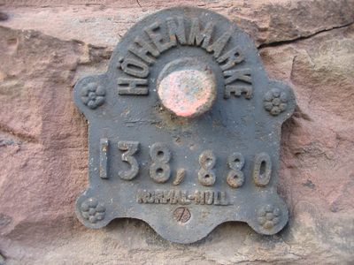
Normalnull, Height reference system in Berlin, Germany
Normalnull was a height reference system in Germany that established the zero point for elevation and depth measurements across the country. The system transferred survey data from the Amsterdam tide gauge to a point in Berlin and created a unified basis for topographic work.
In 1878 surveyors transferred the Amsterdam tide gauge to the New Berlin Observatory and created the technical foundation for a national reference system. One year later the Normalhöhenpunkt was officially established and served as the reference point for elevation measurements in Germany until the successor system Normalhöhennull was introduced.
German engineers and surveyors integrated this measurement standard into their professional practices, influencing infrastructure development throughout the country.
Construction and surveying projects in Germany now use the successor system Normalhöhennull to determine ground elevations and height differences. Engineers and cartographers continue to reference this standardized basis for precise topographic calculations.
The reference point was located 37 meters (121 feet) below the marked Normalhöhenpunkt and existed only as a calculated value without physical marking. This invisible reference plane made it possible to avoid negative elevation values in northern Germany and simplified surveying work in lower-lying areas.
The community of curious travelers
AroundUs brings together thousands of curated places, local tips, and hidden gems, enriched daily by 60,000 contributors worldwide.