Hohe Wurzel, Mountain summit in Taunusstein, Germany
Hohe Wurzel is a 617.9 m high mountain in the Taunus, its summit region forming a roughly 1.1 km long, 300 m wide ridge with a northwest knoll at 617.9 m and a southeast knoll at 613.9 m. The summit is fully forested, but since about 2020 large areas have been cleared because of forest dieback, temporarily opening views over the Taunus and Rheingau.
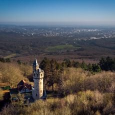
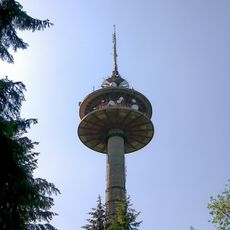
In 1883 the Rhein-Taunus-Klub built the 22.5 m Gustav-Vietor Tower here, a steel frame with an open viewing platform on a rubble-stone base, named after the club's chairman. It was later used for amateur radio and demolished as unsafe in March 2006. About 400 m southeast of the summit stands a 133 m reinforced concrete telecommunications tower broadcasting DVB-T, DAB+ and FM.
The summit lies on the Rheinhöhenweg and the European long-distance path E3, and the Alte Mainzer Weg crosses the main ridge east of the peak, an old road between the Rheingau and the Benedictine monastery at Bleidenstadt. The Gustav-Vietor-Turm, built in 1883 by the Rheintaunusklub and named after its chairman, stood here until its demolition in March 2006.
The hiking trails are clearly marked and start from the Taunuswunderland parking area, with the ascent taking roughly 2 hours. Standard hiking boots are sufficient for the route, and there are no major obstacles along the way.
A concrete tower on the summit broadcasts radio and television signals across the region and shapes the visual landscape distinctly. This structure can be spotted from many places in the surrounding countryside.
The community of curious travelers
AroundUs brings together thousands of curated places, local tips, and hidden gems, enriched daily by 94,041 contributors worldwide.