Grafenberg, Hill in Schorndorf, Germany
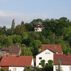
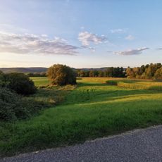
Grafenberg is a 361 m hill in the north of Schorndorf, Baden-Württemberg, rising about 100 m above the Rems. Its cap is harder Kieselsandstein over Gipskeuper, Schilfsandstein and Untere Bunte Mergel on the slopes. A viewpoint a few metres from the top looks over the Remstal to the Schurwald, and the B 29 runs through the 260 m Grafenbergtunnel below its eastern spur.
Vineyards on the Grafenberg were first documented in 1290; the name likely comes from holdings of the Württemberg counts. Today the south- and southeast-facing slopes form the Schorndorfer Grafenberg, the easternmost vineyard site in the Remstal and part of the Korber Kopf collective site, while the southwest slopes toward the Ramsbach valley are used as orchards and gardens.
The name Grafenberg likely refers to land once held by the counts of Württemberg, and the vineyards on its slopes were first documented in 1290. Today the south- and southeast-facing slopes are still planted with vines, including plots leased by the town of Schorndorf where its "Stadtwein" grows; the southwest slopes toward the Ramsbach valley are used as orchards and gardens.
A narrow road from Schorndorf leads up to a hiking car park on the north side of the hill, a few metres from the highest point. From there a viewpoint opens onto the Remstal and the opposite Schurwald, including the Ottilienberg and Galgenberg. The B 29 passes the foot of the hill and runs through the 260 m Grafenbergtunnel.
The hill's name likely comes from land once held by the counts of Württemberg, and the vineyards on its slopes were first documented in 1290. Today the Schorndorfer Grafenberg is the easternmost vineyard site in the Remstal, part of the Korber Kopf collective site, and the city of Schorndorf leases plots where its "Stadtwein" grows.
The community of curious travelers
AroundUs brings together thousands of curated places, local tips, and hidden gems, enriched daily by 94,640 contributors worldwide.