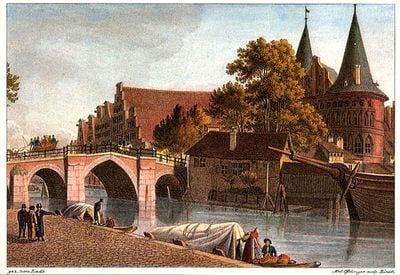
Holstenbrücke, Road and arch bridge near Holstentor, Lübeck, Germany.
The Holstenbrücke is a road and arch bridge that crosses the Trave River and connects the western end of Holstenstrasse with the gateway area leading to the Holstentor. The structure displays the characteristic form of a masonry arch with stone work in its lower sections and modern road surfaces above.
The structure was first documented in 1216 as a wooden construction, but it was destroyed by a storm surge in 1320 and subsequently rebuilt multiple times. The most recent significant transformation occurred in 1934 when the bridge was expanded to handle increased traffic while preserving its core original form.
The bridge takes its name from the nearby gate and has long served as a familiar crossing point between different parts of the city. It remains deeply woven into daily life, connecting neighborhoods in ways that residents navigate without thinking.
The bridge is passable during daylight hours for cars, buses, and pedestrians and serves as a key traffic point, especially when traveling from the harbor to the city center. Visitors should note that the area can become quite crowded during peak times, and space on the walkway may be limited.
The bridge marks the boundary between the upper and lower sections of the Trave and has served generations of residents and visitors as an orientation point in the city. This geographic reference point is less known than the architecture of Holsentor, but plays an equally important role in navigating Lübeck.
The community of curious travelers
AroundUs brings together thousands of curated places, local tips, and hidden gems, enriched daily by 60,000 contributors worldwide.