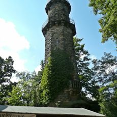
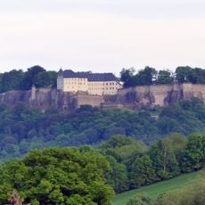
Quirl, Summit in Königstein, Germany
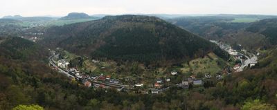
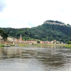
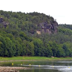
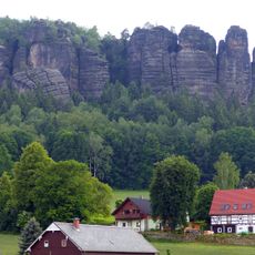
Quirl is a sandstone table mountain rising 349 meters in Saxon Switzerland, combining sheer cliff faces with a wide, open plateau on top. The summit offers expansive views across the surrounding landscape and forested valleys.
During the 1866 conflict in the region, military forces destroyed the pathways to prevent cannon placement on the plateau. Since then, the mountain has been rebuilt as a hiking destination without military significance.
The plateau served as pastureland for nearby farms for many generations. You can still see traces of this agricultural use in how the land is shaped, though active farming here ended decades ago.
Marked hiking trails depart from Königstein town center and reach the plateau in about 2.5 kilometers. The path includes some steep sections that require careful footing, but the route is generally accessible to most visitors.
The northern slope contains the Diebskeller cave, the largest cave formation in Saxon Switzerland covering about 230 square meters. This underground chamber offers a surprising discovery for hikers who explore beyond the main plateau views.
Location: Königstein
Elevation above the sea: 349.6 m
GPS coordinates: 50.90790,14.06239
Latest update: December 13, 2025 17:08
Königstein Fortress
1.3 km
Pfaffenstein
1.6 km
Barbarine
1.7 km
Königstein
1.2 km
Stadtkirche St. Marien Königstein
1.3 km
Sächsische Schweiz
2.6 km
Cemetery in Königstein
948 m
Aussichtsturm Pfaffenstein
1.6 km
Apostolische Kirche
1 km
Church of the Immaculate Conception
818 m
Pfaffenstein
1.4 km
Alte Kaserne (Festung Königstein)
1.3 km
Papierfabrik Louisenthal, Werk Königstein
624 m
Schacht 390
2.3 km
Sachgesamtheit Rittergut Thürmsdorf mit folgenden Einzeldenkmalen: Schlosskomplex und zwei Skulpturen im Park (siehe Einzeldenkmalliste - Obj. 09224693), das Mausoleum der Familie Biedermann östlich des Gutskomplexes (siehe Einzeldenkmalliste - Obj
2.7 km
Pfaffenberg 15, Königstein
1.3 km
Polish-Saxon Post Milestone in Königstein
1.3 km
Denkmal für die Gefallenen des Ersten Weltkrieges Pfaffendorfer Straße -
1.3 km
'''Festung Königstein''' – Torhaus, Kommandantenhaus, Georgenburg, Neues Zeughaus und Caponnierengang, Brunnenhaus, Magdalenenburg, St. Georgs-Kapelle, dazugehörend die fortifikatorischen Anlagen (Einzeldenkmale zu ID-Nr. 09301198) Alte Festungss
1.3 km
Sachgesamtheit '''Festung Königstein mit Rayon''' mit Einzeldenkmalen, u. a. Torhaus, Kommandantenhaus, Georgenburg, Neues Zeughaus und Caponnierengang, Brunnenhaus, Magdalenenburg, St. Georgs-Kapelle, Alte Kaserne, Schatzhaus, Hauptwache sowie Gär
1.3 km
Pfaffensteinweg 5
1.4 km
Biedermann-Mausoleum
2.7 km
Berggasthof Pfaffenstein
1.6 km
Ebenheit 8b and 8c
2.2 km
Schloss Thürmsdorf
2.7 km
Rathaus Goethestraße 7
1.3 km
Schacht 388
2.3 km
Pfaffenberg 31, Königstein
1.3 kmVisited this place? Tap the stars to rate it and share your experience / photos with the community! Try now! You can cancel it anytime.
Discover hidden gems everywhere you go!
From secret cafés to breathtaking viewpoints, skip the crowded tourist spots and find places that match your style. Our app makes it easy with voice search, smart filtering, route optimization, and insider tips from travelers worldwide. Download now for the complete mobile experience.
A unique approach to discovering new places❞
— Le Figaro
All the places worth exploring❞
— France Info
A tailor-made excursion in just a few clicks❞
— 20 Minutes