Enable Location

We need your location to show you interesting places around you

Discover nearby places

Find interesting locations and hidden gems around you

Precise directions

Get accurate directions and distances to places

Your location is never shared with other users. It's only used when you tap the location button.

Canal de l'Aisne à la Marne

Log in to your account

Join the adventure

Create your free account and start exploring (like 60k+ others)

We will send you a code to connect

or
Continue with Google
Continue with Apple
By continuing, you accept our Terms and Conditions and our Privacy Policy

Check your inbox

We've sent a pincode in your inbox. Please enter the code below.

Canal de l'Aisne à la Marne

Canal de l'Aisne à la Marne, Summit level canal in northeastern France

Description

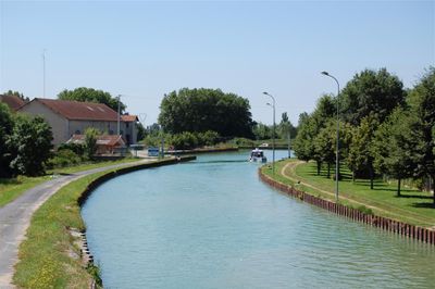
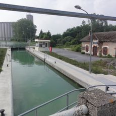
The Canal de l'Aisne à la Marne is a summit level canal in northeastern France connecting two major rivers. It traverses a plateau by means of locks and a substantial underground tunnel, allowing boats to cross terrain that would otherwise block their passage.

History

Construction began in 1841 and the canal opened in 1866 as a link in a broader network designed to connect the Loire with northern France. The project demonstrated France's commitment to modernizing its transport infrastructure during the industrial age.

Culture

The waterway reflects French engineering ambition and shows how people in the 19th century connected rivers to move goods across the country. Today visitors can walk along the banks and observe the lock system up close, understanding how commerce flowed through these waters.

Practical

The canal banks are easily accessible for walking and observing lock operations throughout their course. The best visiting season is spring through fall when more boat traffic is visible and the towpaths are most pleasant to walk.

Did you know?

The tunnel beneath Mont-de-Billy is one of France's longest underground passages and was dug entirely by hand. This hidden waterway allows boats to pass under terrain that would have made the route impossible without it.

GPS coordinates
49.39889,3.90528
Latest update
December 6, 2025 17:42

AroundUs brings together thousands of curated places, local tips, and hidden gems, enriched daily by 60,000 contributors worldwide. Discover all places nearby (France).

Photography in Reims: Gothic cathedral, Roman ruins, champagne caves

Reims is a city where different historical periods naturally exist side by side, making it a favorite for photographers. Churches and palaces from the Middle Ages stand near Roman ruins, while underground caves have been turned into champagne cellars. These underground spaces offer special settings,...

« Canal de l'Aisne à la Marne - Summit level canal in northeastern France » is provided by Around Us (aroundus.com). Images and texts are derived from Wikimedia project under a Creative Commons license. You are allowed to copy, distribute, and modify copies of this page, under the conditions set by the license, as long as this note is clearly visible.

Discover hidden gems everywhere you go!

From secret cafés to breathtaking viewpoints, skip the crowded tourist spots and find places that match your style. Our app makes it easy with voice search, smart filtering, route optimization, and insider tips from travelers worldwide. Download now for the complete mobile experience.

Around Us App Screenshot

A unique approach to discovering new places

Le Figaro

All the places worth exploring

France Info

A tailor-made excursion in just a few clicks

20 Minutes

Around Us
Travel Guide & Maps
Download

Send to your phone

QR Code
1

Open the camera app on your mobile.

2

Point at the QR code with your camera. A notification will appear.

3

Tap the notification to open the link.