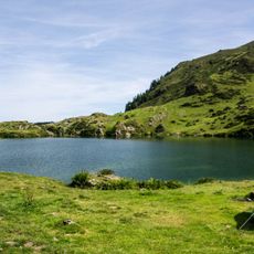
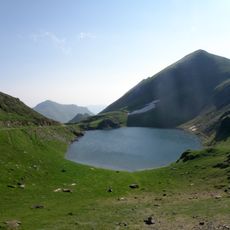
Lac de Bethmale, lake in France
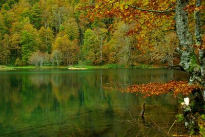
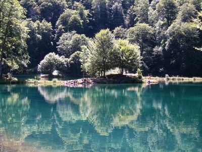
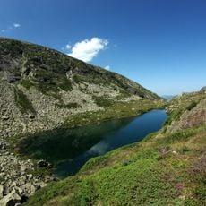
Lac de Bethmale is an artificial reservoir divided into three basins, surrounded by beech forests at about 1,070 meters (3,510 feet) elevation in the central Pyrenees. A wooden boardwalk runs along the shoreline, allowing easy access for people with limited mobility and families pushing strollers.
The name Bethmale comes from the Gascon language, combining 'beth' meaning beautiful and 'malh' referring to rocky mountain terrain. This artificial reservoir was created later to serve the water needs of the mountain community.
Fishing is a central activity here from May to October, when people come to catch trout and salmon in these first-category waters. This practice shapes how locals and visitors experience the place throughout the year.
Wear sturdy footwear since paths around the water can be uneven and slippery in places. The best time to visit is from May through October when weather is stable and all facilities are fully accessible.
The water glimmers with an emerald-green hue created by specific algae species, reflecting the dense forests and mountains surrounding it. This color shifts throughout the day depending on the light angle, constantly changing the view as you walk around the water.
Location: Bethmale
Elevation above the sea: 1,074 m
Part of: Forêt domaniale de Bethmale
Address: Lac de Bethmale, 09800 Bethmale, France
GPS coordinates: 42.86080,1.08389
Latest update: December 6, 2025 17:41
Occitanie hosts a wide variety of lakes spread between the Pyrenees and the Massif Central. Natural lakes mainly occupy high-altitude zones in the Pyrenees, where glacial erosion has carved out cirques and basins now filled with water. Lake Oô, located at 4,950 feet (1,507 meters) altitude, receives...
Mont Valier
7 km
Maison-forte de Seix
9.6 km
Arcouzan Glacier
6.9 km
Église Notre-Dame d'Ourjout
6.5 km
Château de la Garde
10.1 km
Église Saint-Pierre
7.8 km
Église Notre-Dame-de-Tramesaygues
9.1 km
Étang d'Ayès
2.7 km
Église de Luzenac
10.4 km
Chapelle d'Aulignac
7.2 km
Tuc de Barlonguèra
10.1 km
Étang d'Areau
10.3 km
Pont de Bordes-sur-Lez
6.4 km
Dolmen d'Ayer
6.2 km
Église Saint-Étienne d'Uchentein
7.4 km
Chapelle Notre-Dame-de-Pitié
9.5 km
Étang de Pra Matau
10.5 km
Église Saint-Lizier de Balacet
8.7 km
Étang d'Arauech
5.6 km
Pic de Clavera
8.1 km
Église Saint-Jacques de Sentenac-d'Oust
7.8 km
Église Saint-André de Salsein
8.2 km
Église Saint-Pierre d'Arrout
10.4 km
Église Saint-Genez de Cescau
8.6 km
Église Saint-Michel d'Arrien-en-Bethmale
5.3 km
Église Notre-Dame-de-l'Assomption d'Alos
7.3 km
Église de la Décollation-de-Saint-Jean-Baptiste de Bonac
9.1 km
Église Saint-Jean-Baptiste de Pouech
10.5 kmVisited this place? Tap the stars to rate it and share your experience / photos with the community! Try now! You can cancel it anytime.
Discover hidden gems everywhere you go!
From secret cafés to breathtaking viewpoints, skip the crowded tourist spots and find places that match your style. Our app makes it easy with voice search, smart filtering, route optimization, and insider tips from travelers worldwide. Download now for the complete mobile experience.
A unique approach to discovering new places❞
— Le Figaro
All the places worth exploring❞
— France Info
A tailor-made excursion in just a few clicks❞
— 20 Minutes