Enable Location

We need your location to show you interesting places around you

Discover nearby places

Find interesting locations and hidden gems around you

Precise directions

Get accurate directions and distances to places

Your location is never shared with other users. It's only used when you tap the location button.

Rivière souterraine de Labouiche

Log in to your account

Start exploring — it's free

Trusted by 62,386 travelers worldwide

Continue with Google
Continue with Apple
or

We will send you a code to connect

By continuing, you accept our Terms and Conditions and our Privacy Policy

Check your inbox

We've sent a pincode in your inbox. Please enter the code below.

Rivière souterraine de Labouiche

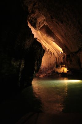
Rivière souterraine de Labouiche, Subterranean river in Vernajoul, France.

Rivière souterraine de Labouiche is an underground river flowing through limestone caves beneath Vernajoul, shaped by centuries of water erosion. The passages display natural pools and rock formations carved by the flowing water.

The cave system was first discovered in 1908 by Dr. Dunac and his team following the Fajal stream. This exploration revealed one of Europe's major underground waterways.

Local guides name rock formations after regional folklore, giving visitors a sense of how people historically made sense of this underground world. These narratives show how the cave became part of local storytelling and memory.

Visitors need sturdy footwear and good balance due to slippery rocks and steep passages. Warm clothing is essential as temperatures remain cool throughout the year.

This is Europe's longest navigable underground river system, allowing visitors to actually travel by boat through sections of it. The experience of floating through cave passages is rare and stays with travelers long after they leave.

The community of curious travelers

AroundUs brings together thousands of curated places, local tips, and hidden gems, enriched daily by 60,000 contributors worldwide.

Start exploring
Location
Location
Location
GPS coordinates
43.00330,1.57278
Latest update
December 6, 2025 17:43
Natural areas in France: mountain lakes, limestone gorges, and forests

France features a notable variety of protected natural areas, showcasing the country’s geological and ecological richness. From Lake Allos in the Alpes-de-Haute-Provence to the underground rivers of Padirac in Dordogne, from the mountain ranges of Savoy to the limestone formations of the Ardèche...

« Rivière souterraine de Labouiche - Subterranean river in Vernajoul, France » is provided by Around Us (aroundus.com). Images and texts are derived from Wikimedia project under a Creative Commons license. You are allowed to copy, distribute, and modify copies of this page, under the conditions set by the license, as long as this note is clearly visible.

Discover hidden gems everywhere you go!

From secret cafés to breathtaking viewpoints, skip the crowded tourist spots and find places that match your style. Our app makes it easy with voice search, smart filtering, route optimization, and insider tips from travelers worldwide. Download now for the complete mobile experience.

Around Us App Screenshot

A unique approach to discovering new places

Le Figaro

All the places worth exploring

France Info

A tailor-made excursion in just a few clicks

20 Minutes

Around Us
Travel Guide & Maps
Download

Send to your phone

QR Code
1

Open the camera app on your mobile.

2

Point at the QR code with your camera. A notification will appear.

3

Tap the notification to open the link.