See the monuments around you in AROpen chests in the app
Around Us is built for your phone — point your camera at the streets and discover the monuments and places around you in augmented reality.Around Us is built for your phone — chests unlock when you walk, explore and capture nearby places.
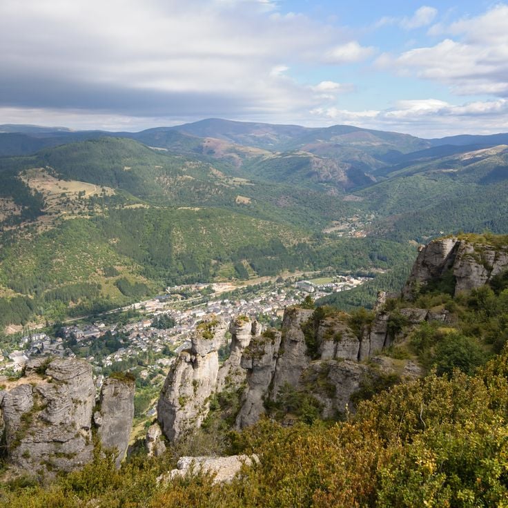
Natural areas in France: mountain lakes, limestone gorges, and forests
France features a notable variety of protected natural areas, showcasing the country’s geological and ecological richness. From Lake Allos in the Alpes-de-Haute-Provence to the underground rivers of Padirac in Dordogne, from the mountain ranges of Savoy to the limestone formations of the Ardèche gorges, each region displays landscapes shaped over millennia of natural evolution.
This collection gathers sites where nature is expressed freely: primary forests, karst systems, high-altitude lakes, moving dunes of the Atlantic coast, and rock formations carved by erosion. These areas provide diverse ecosystems, home to species adapted to different environments, from Alpine flora and fauna to dune communities and underground cave biodiversity.
Each natural site in this selection serves as an open-air laboratory where geological processes, ecosystem dynamics, and living adaptation to local conditions can be observed. These sites invite discovery of authentic landscapes, removed from human impact, where geological time is evident in every rock formation and glacier valley.
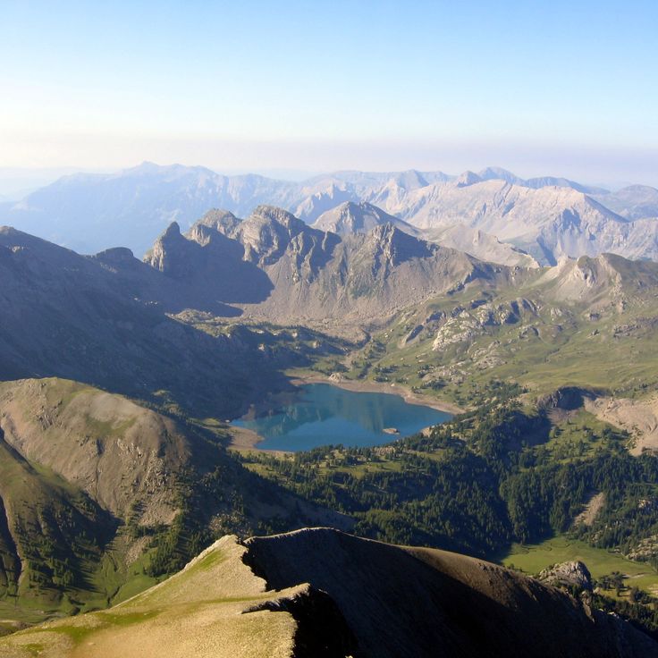
Lac d'Allos sits at 2230 meters altitude and covers 54 hectares with a maximum depth of 48 meters. This mountain lake is the largest natural high-altitude lake in the French Alps and lies within Mercantour National Park in the Alpes-de-Haute-Provence. The lake formed through glacial erosion during the last ice age and receives water from snowmelt. The trail to Lac d'Allos starts from a parking area at 2100 meters and passes through alpine meadows with rhododendrons and edelweiss.
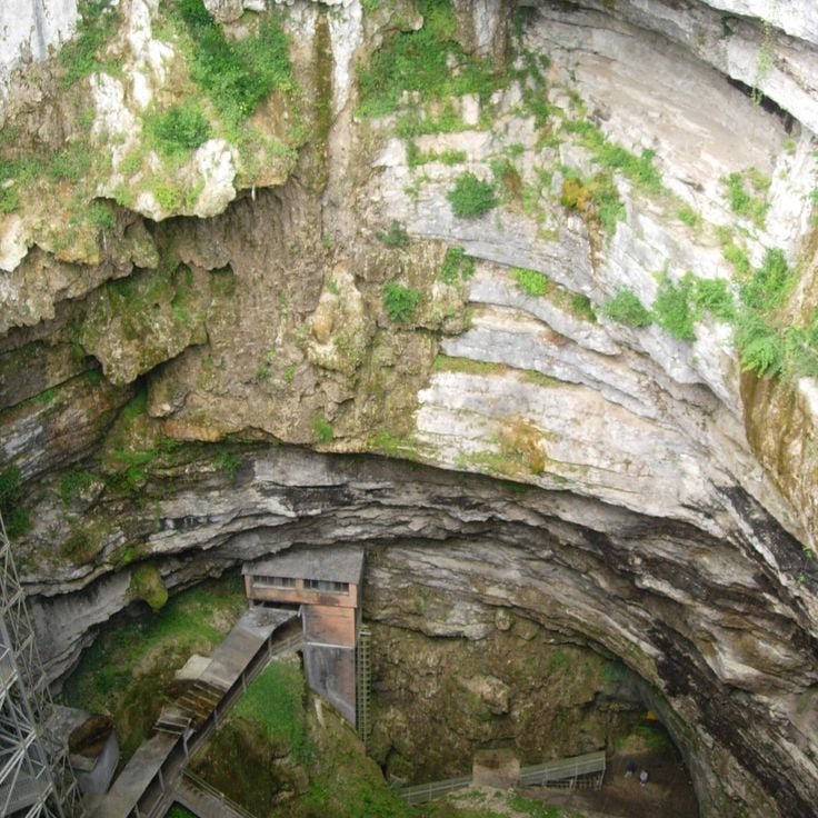
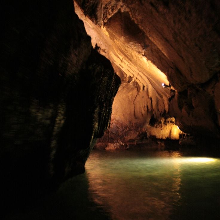
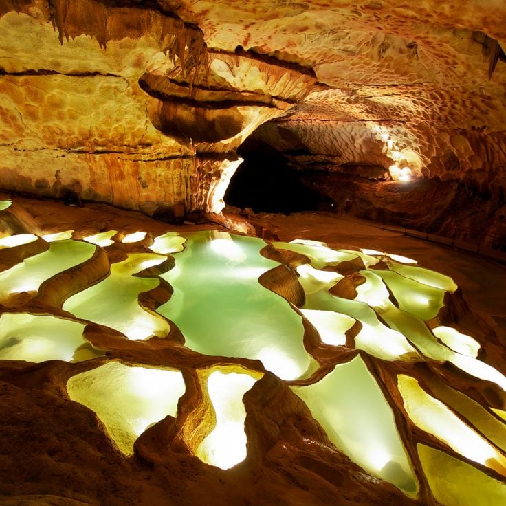
The Gouffre de Padirac is a natural cave in the Lot department, accessible through a vertical opening 103 meters deep. The underground network extends over 40 kilometers of galleries through which a river flows. Visitors descend into the depths and travel by boat on the subterranean waterway. The cave displays formations of stalactites and stalagmites, along with large underground chambers. The vault of the Grande Pendeloque reaches a height of 94 meters.
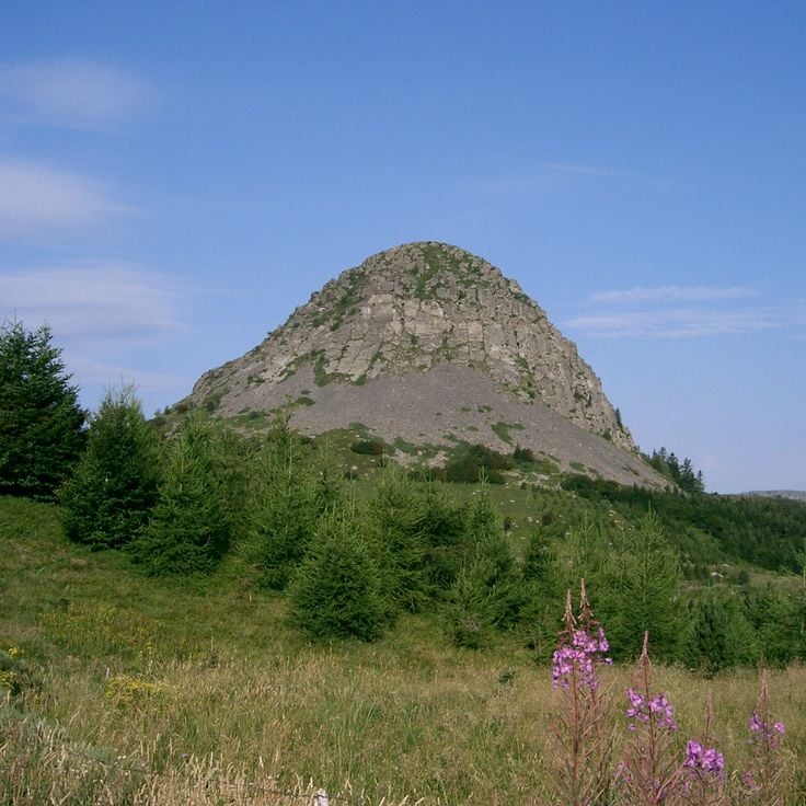
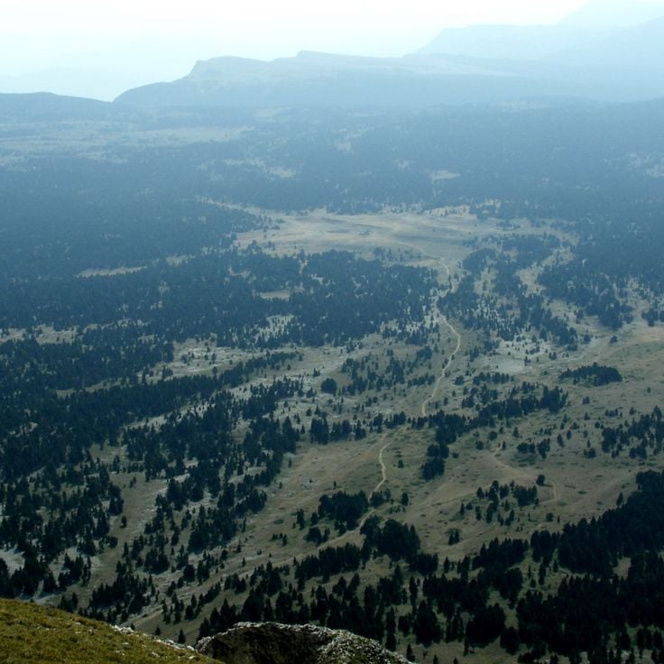
Mont Gerbier de Jonc is a volcanic mountain in the Ardèche department rising to 1551 meters in elevation. At its base, the Loire River, France's longest river, begins its course. The phonolitic dome formed through volcanic activity and stands today as a geological landmark of the region. Several marked hiking trails lead to the summit, offering views over the surrounding plateaus and mountains. The mountain lies within the Monts d'Ardèche Regional Natural Park and attracts hikers and geology enthusiasts.
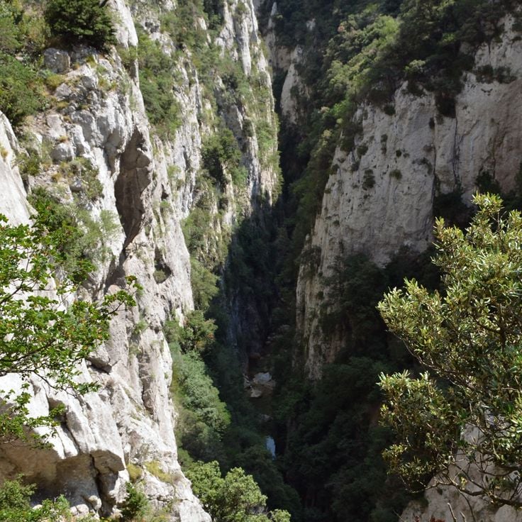
The Gorges du Tarn form a limestone canyon in the Lozère department, carved by the erosion of the Tarn River. This gorge extends over 50 kilometers between the Causses plateaus and reaches depths of 500 meters in certain sections. Steep limestone cliffs frame the river that has cut through the rock over millennia. Several villages such as Sainte-Énimie are situated along the gorge. The Gorges provide opportunities for canoeing, hiking, and rock climbing. This geological formation belongs to the Cévennes National Park and displays characteristic karst landscapes with caves and rock formations.
Causse Méjean extends across 340 square kilometers of limestone plateau at an average elevation of 1000 meters. This high plateau lies between the Tarn and Jonte gorges and forms one of the major limestone plateaus of the Cévennes. The landscape features sparse grazing lands, sinkholes, and traditional sheep farming. Causse Méjean is part of the Cévennes National Park and was designated a UNESCO World Heritage Site as part of the Mediterranean agropastoral landscape.
The Forest of Fontainebleau covers 25000 hectares southeast of Paris and features an extensive network of trails through pine and oak woodlands. This historic forest area is characterized by distinctive sandstone formations that attract climbers from around the world. The forest served French royalty as hunting grounds for centuries and now hosts diverse flora and fauna with numerous protected species.
This regional nature park spans the Vosges Mountains and includes peaks reaching 1,424 meters, extensive coniferous forests, glacial lakes and traditional mountain villages. The protected area preserves the characteristic landscapes of the medium-altitude mountain range with high pastures, peat bogs and granite rock formations. Visitors find a dense network of hiking trails through fir and beech forests, as well as cross-country skiing opportunities in winter. The region is known for its local architecture featuring half-timbered houses and its cheese production.
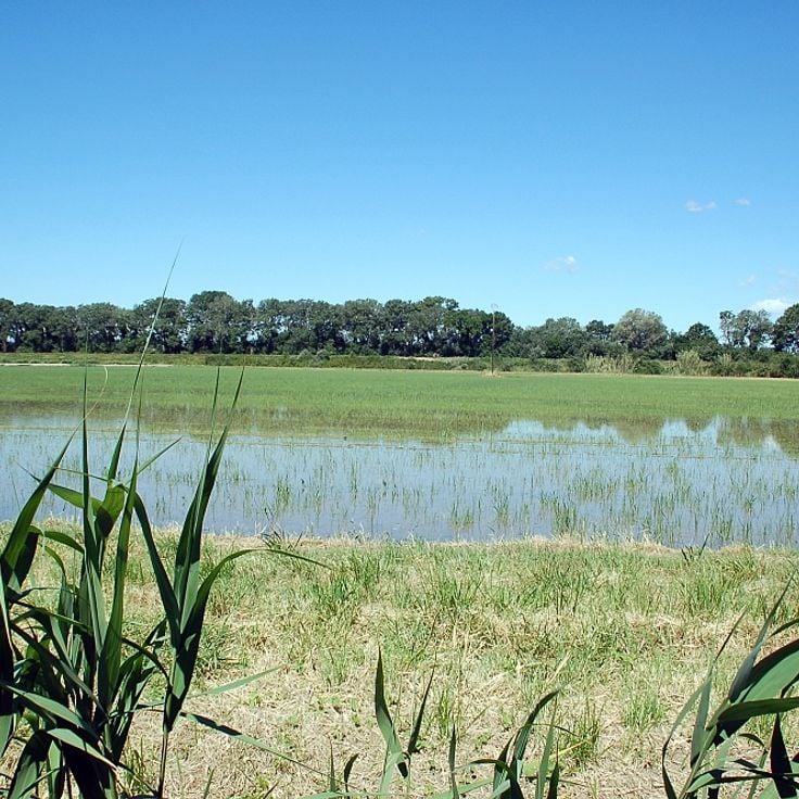
The Camargue extends across the Rhône delta, forming a wetland area of 100000 hectares. This regional nature reserve includes salt marshes, rice fields and lagoons that provide habitat for numerous bird species such as flamingos. The region also supports white horses and black bulls living in semi-wild conditions. The salines, former salt extraction sites, shape the landscape alongside extensive reed beds bordering the water surfaces.
The Aiguilles de Bavella form a group of granite peaks rising in southern Corsica to a height of 1900 meters. These reddish granite towers are characterized by their distinctive needle shapes, which give the mountain range its name. The massif offers numerous climbing routes of varying difficulty levels and attracts mountaineers from across Europe. Several hiking trails cross the region, connecting the peaks with the surrounding Laricio pine forests.
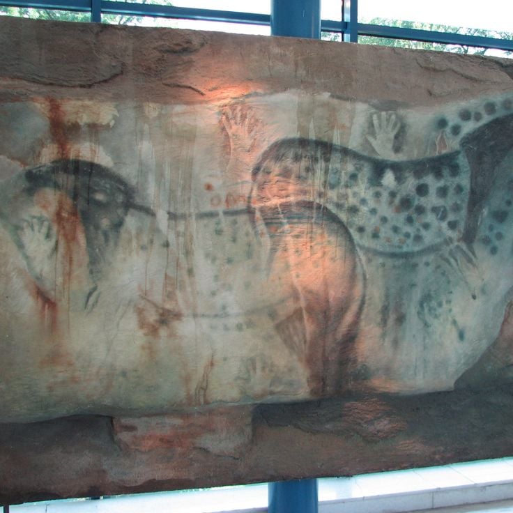
The Grotte du Pech Merle was discovered in 1922 by two teenagers and contains over 700 prehistoric cave paintings from the Paleolithic period, dating back between 25,000 and 29,000 years. The cave extends over two kilometers and displays representations of mammoths, bison, horses with characteristic spotted patterns, as well as hand prints and geometric signs. The drawings were created using charcoal, ochre, and manganese oxide applied to the limestone walls. Located in the Quercy region in the commune of Cabrerets, the cave can be visited through guided tours, with visitor numbers limited to preserve the artwork.
The Cirque de Cagateille is a glacial basin in the Pyrenees surrounded by 500-meter limestone cliffs. The valley was formed during the last ice ages through glacial erosion. Several waterfalls cascade down the rock faces and feed the mountain meadows in the basin floor. Access is via hiking trails that pass through beech forests and alpine pastures.
The Réserve Naturelle des Hauts Plateaux du Vercors covers 17000 hectares on plateaus ranging from 1600 to 2300 meters in altitude. Established in 1985, this protected area is now the largest nature reserve in France. Chamois and marmots inhabit this alpine environment characterized by karst landscapes with sinkholes and underground water systems. The plateaus offer numerous hiking trails through beech forests and open areas. Winter conditions are extreme with strong winds and freezing temperatures.
The Parc national des Écrins covers 91800 hectares in the French Alps and includes 150 peaks exceeding 3000 meters in elevation along with approximately 100 glaciers. This protected area supports a rich alpine flora and fauna, including ibex, chamois, and marmots. The landscape features deep valleys, mountain lakes, and extensive coniferous forests. The park provides numerous hiking trails across different elevation zones and offers mountaineers access to several peaks above 4000 meters. Traditional mountain villages at the park's edges reflect the centuries-old relationship between people and mountains.
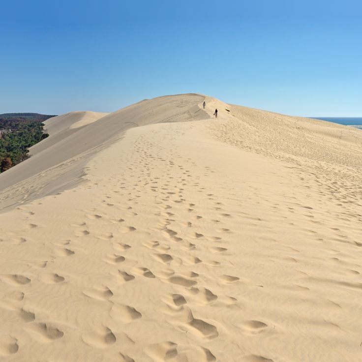
The Dune du Pilat rises 110 meters above sea level and extends 2.7 kilometers along the Atlantic coast. This sand dune moves between 1 and 5 meters inland each year and continuously changes shape due to wind and tides. From its summit, it offers extensive views of the ocean, the Arcachon Basin, and the pine forests beyond. The fine sand originates from the seabed and is transported to the shore by ocean currents.
The Trou de Bozouls is a horseshoe-shaped canyon formed by the erosion of the Dourdou River. The limestone cliffs of this geological formation rise approximately 100 meters high and encircle the medieval village of Bozouls. The canyon extends over 400 meters in length and offers several viewpoints from which visitors can observe the rock formations and the river course below.
The Parc national des Cévennes covers 91,000 hectares in the southern Massif Central and protects more than 2,000 plant species. This reserve includes granite peaks such as Mont Lozère and Mont Aigoual, extensive chestnut and beech forests, and numerous medieval villages built with schist stone. The national park combines Mediterranean and continental climate zones and provides habitat for mouflon sheep, deer, and over 200 bird species.
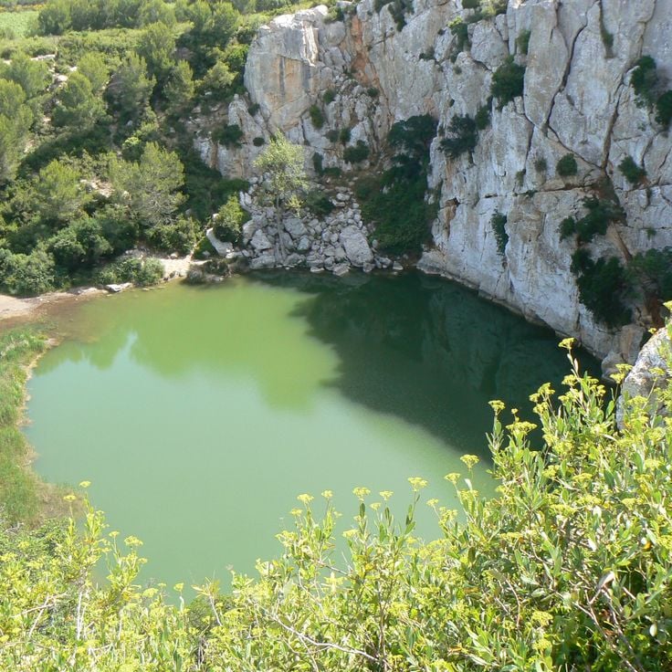
The Gouffre de l'Oeil-Doux is a circular sinkhole formed by the collapse of an underground cave. The basin measures approximately 50 meters in diameter and contains emerald green water reaching a depth of 20 meters. Steep limestone walls surround this natural formation, which is separated from the sea by a narrow rocky ridge. The surrounding area features typical Mediterranean vegetation with garrigue scrubland. Access is via a coastal walking path between Gruissan and the Massif de la Clape.
The Forêt de Brocéliande covers 7000 hectares in the heart of Brittany. This woodland consists mainly of oaks and beeches forming a dense canopy. Since medieval times, numerous legends have connected these woods to King Arthur, Merlin and the Knights of the Round Table. Visitors discover ancient stones, springs and clearings mentioned in the literary tales of the Arthurian cycle. The forest remains a place where history and mythology meet.
The Volcans d'Auvergne form a volcanic chain in the French Massif Central, comprising 80 extinct volcanoes spread over 45 kilometers. The Puy de Dôme rises to 1465 meters and dominates the landscape. The last volcanic activity occurred approximately 6000 years ago. The area offers numerous hiking trails through lava fields, crater lakes and forested volcanic slopes. The geological formations display various eruption types and volcanic structures.
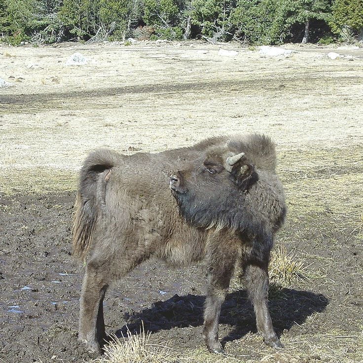
The Parc à bisons de Sainte-Eulalie provides a home for a herd of 30 European bison across 200 hectares of natural terrain. The park encompasses pine and beech forests in the Lozère department, allowing visitors to observe these large mammals in their natural environment.
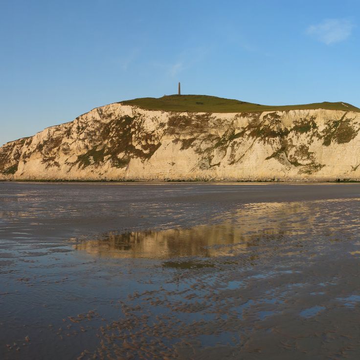
Cap Blanc Nez rises 134 meters above sea level and forms a prominent point on the French Channel coast. The limestone cliffs belong to the geological formation that extends along the Strait of Dover. From this headland, visitors can see the white cliffs of Dover on clear days, located just 34 kilometers away across the water. The coastal cliffs feature walking paths along the GR 120 trail that runs through northern France. The area is managed by the Conservatoire du littoral and protects the typical vegetation of limestone cliffs as well as various seabird species that nest here.
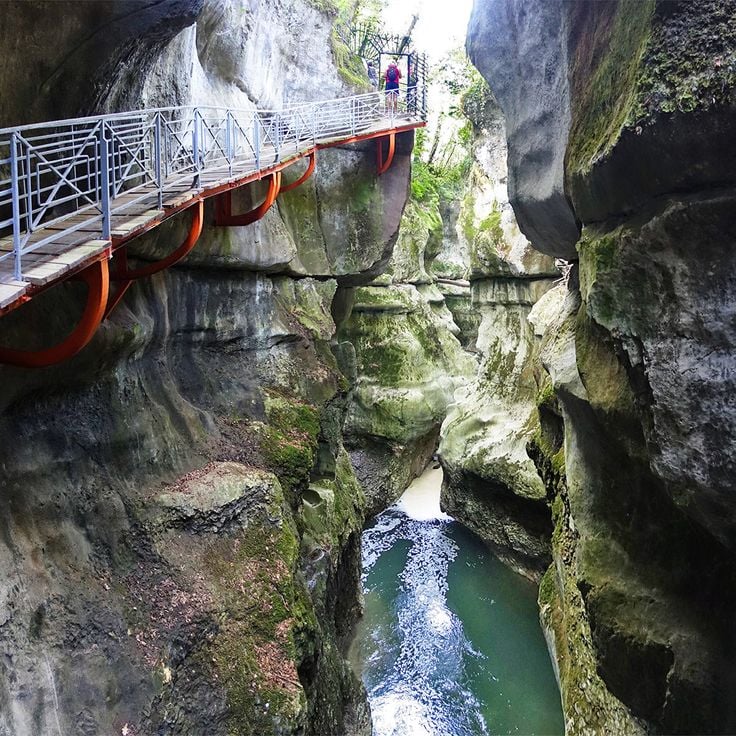
The Gorges du Fier provide access via a metal walkway positioned 25 meters above the river. The gorge reaches a depth of 40 meters and displays steep limestone walls shaped by thousands of years of erosion. The circuit extends approximately 300 meters and allows observation of geological formations and the river landscape. This natural formation is located near Annecy and remains accessible to visitors during the summer months.
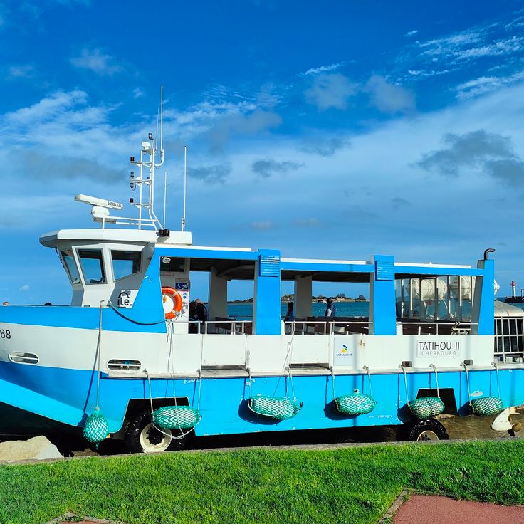
The Île de Tatihou covers 28 hectares off the coast of Normandy. The island houses 17th-century military fortifications built under Vauban. At low tide, visitors can walk to the island across the seabed, while at high tide an amphibious vehicle provides transport. The island features a maritime history museum, botanical gardens and bird observation stations. The fort served for centuries as a defensive installation and later as a quarantine station.
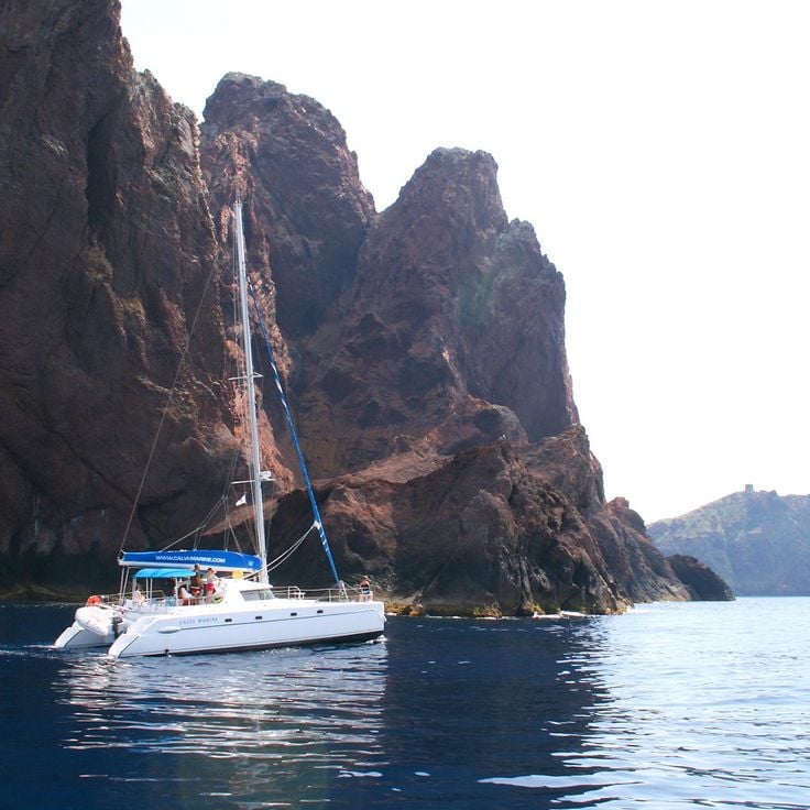
The Réserve Naturelle de Scandola covers 1919 hectares along the western coast of Corsica, protecting both marine and terrestrial ecosystems. This reserve is characterized by its geological formations of red volcanic rock that rise directly from the Mediterranean Sea. The area includes steep cliffs, sea caves, and submarine rocks that provide habitat for numerous species. Ospreys nest on the cliff faces, while groupers and red coral inhabit the waters. The reserve is accessible only by boat and was designated a UNESCO World Heritage Site in 1983.
The underground Rivière de Labouïche is a natural cave system that can be navigated by boat for 1500 meters. This geological formation was created through limestone erosion and now forms an underground river with several galleries and chambers. Visitors traverse different cavities featuring stalactites and stalagmites while the boat glides through the river current. The interior temperature remains constant at approximately 13 degrees Celsius.
The Pic Est de Bargy rises to 2,121 meters in the Massif du Bargy within the French Alps. This limestone summit stands in a protected area known for its population of bearded vultures. These rare raptors use the rock ledges for nesting and drop bones from great heights to access the marrow inside. The area forms part of the Réserve Naturelle des Aiguilles Rouges and provides habitat for alpine fauna and flora. Hikers reach the summit via marked trails that pass through mountain pastures and karst landscapes.
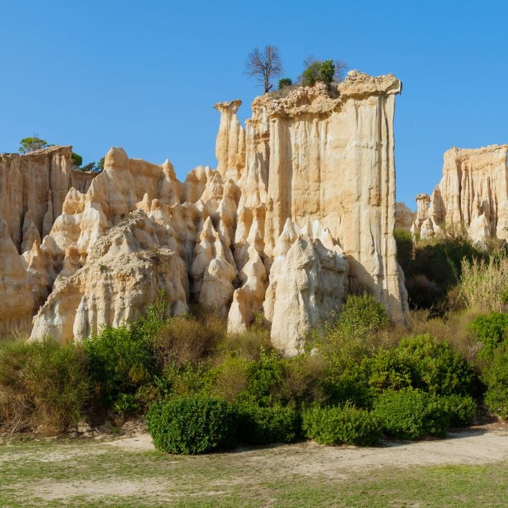
These sandstone columns in the Catalan Piedmont were shaped by wind and rain erosion over thousands of years. Les Orgues d'Ille-sur-Têt rise up to 12 metres high and display clearly visible layers in reddish and grey tones, representing different sedimentary deposits from various geological epochs. The site extends over several hectares and offers marked walking trails between the formations. The mineral-rich soils date from the Tertiary period and have been continuously reshaped by thermal contrasts and rainfall.
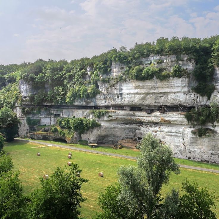
La Roque Saint-Christophe rises as a massive limestone cliff over one hundred meters high along the Vézère River. This natural formation extends for one kilometer in length and presents five superimposed levels of caves and rock shelters. Archaeological evidence documents continuous human occupation spanning 55,000 years, from Neanderthals through the 16th century. The caves served as dwellings, workshops, and defensive positions. During the Middle Ages, a fortified settlement developed here with houses, streets, and a pulley system for goods. Today, reconstructed elements including ladders, staircases, and wooden structures enable understanding of the historical use of this extraordinary cliff dwelling. The site offers a comprehensive view of how humans adapted to and utilized this natural rock formation across millennia.
The Marais Poitevin extends over 112,000 hectares across the Vendée, Deux-Sèvres and Charente-Maritime departments. This wetland consists of a network of channels lined with ash and poplar trees. The area divides into dry marshland with agricultural fields and wet marshland with its waterways. Visitors can explore the channels by flat-bottomed boat while observing the region's characteristic flora and fauna. The area serves as habitat for numerous bird species and aquatic plants.
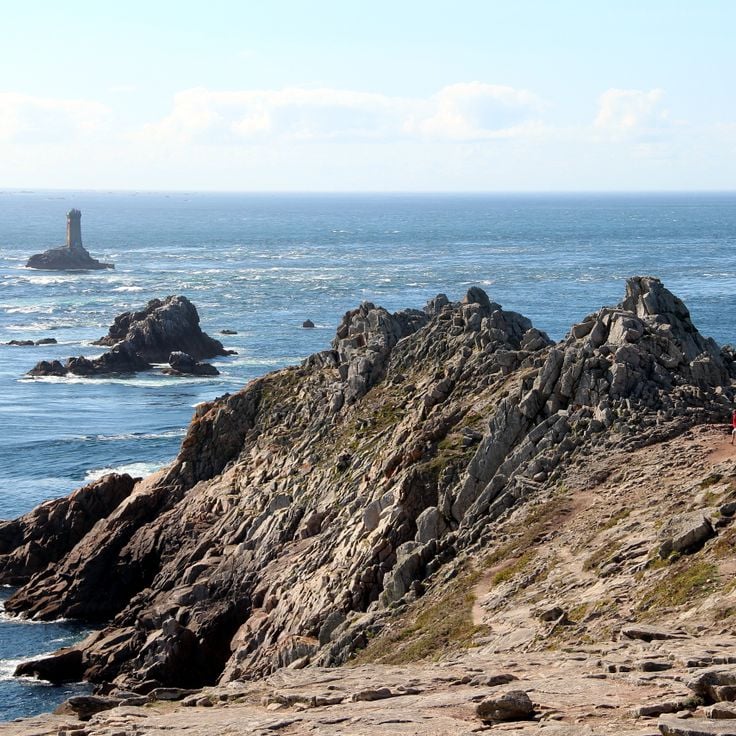
The Pointe du Raz rises as a steep rocky formation 72 meters above the Atlantic Ocean at the western tip of Brittany. This location marks one of the westernmost points of mainland France and provides views over the open sea and the offshore Île de Sein. The cliffs consist of granite rock shaped by wind and waves. Several walking paths run along the coast and allow access to various viewpoints overlooking the rocky coastline.
The Grotte de St Marcel d'Ardèche opens onto an extensive underground network spanning 57 kilometers in length. This cave contains several subterranean lakes, numerous stalactites and stalagmites, along with prehistoric wall paintings that testify to early human occupation of the region. The geological formations document thousands of years of limestone dissolution by water.
The Gorge de Galamus is a narrow canyon carved by the Agly River, located between the communes of Saint-Paul-de-Fenouillet and Cubières-sur-Cinoble. This geological formation cuts through limestone massifs with rock walls reaching up to 500 meters in height. A path carved into the rock follows the river course and allows hikers to traverse the gorge. The Chapel of Saint-Antoine de Galamus, a 17th-century hermitage built into the cliff face, stands at the entrance to the gorge and is accessible via steps cut into the stone.
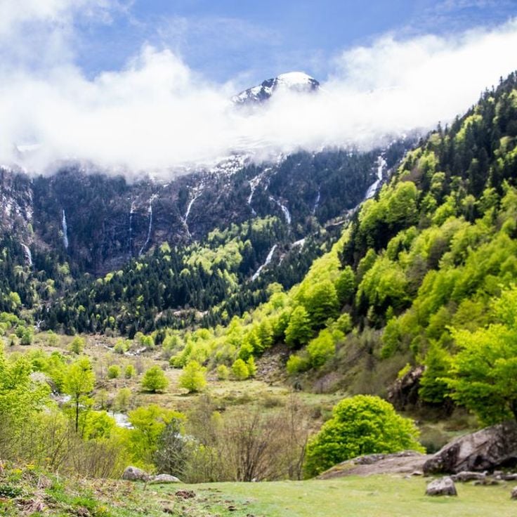
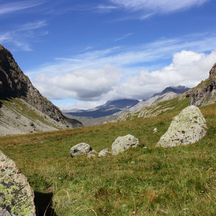
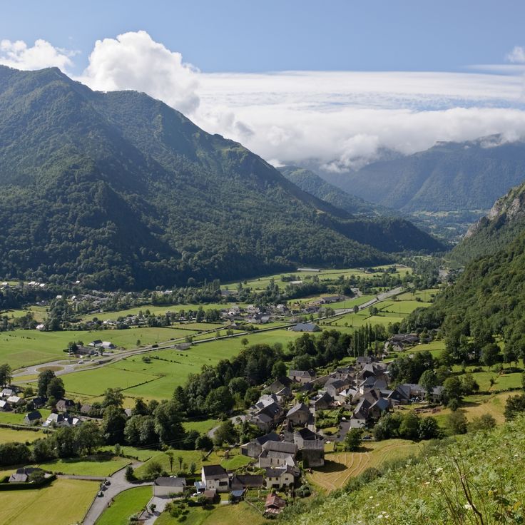
The Vallée d'Ossau extends through the western Pyrenees, following the course of the Gave d'Ossau river. The valley provides access to several mountain lakes, including Lac d'Ayous and Lac de Bious-Artigues. Hiking trails cross alpine meadows and forests that reach toward the peaks. Traditional villages in the region maintain the pastoral architecture characteristic of the Pyrenees. During winter months, the higher elevations serve as starting points for snowshoeing and ski touring.
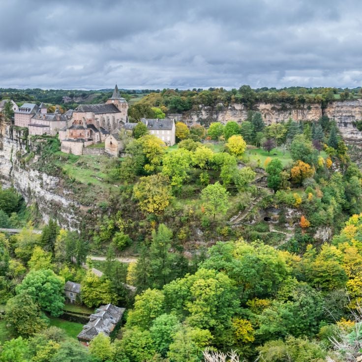
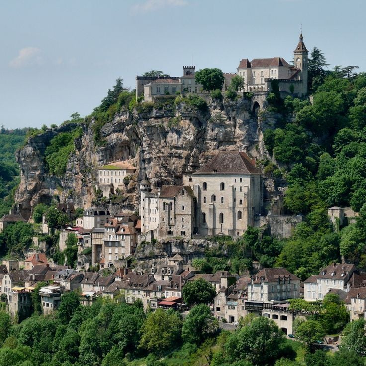
Rocamadour is a medieval town built on a 150-metre limestone cliff. The settlement extends across several levels and includes seven religious buildings, among them the Chapelle Notre-Dame housing a 12th-century Black Madonna. The 14th-century château sits atop the town and provides access to the fortifications. Steep lanes and staircases connect the different levels of the town, which has been a major pilgrimage site since medieval times.
Parc national de la Vanoise was established in 1963 as France's first national park, covering 53,500 hectares in the Savoie Alps. The territory includes 107 peaks exceeding 3,000 meters in elevation, including Grande Casse at 3,855 meters. The park protects alpine ecosystems with glaciers, high-altitude pastures and valleys. Wildlife includes ibex, chamois and marmots. The trail network provides access to different elevation zones from coniferous forests to moraine landscapes.
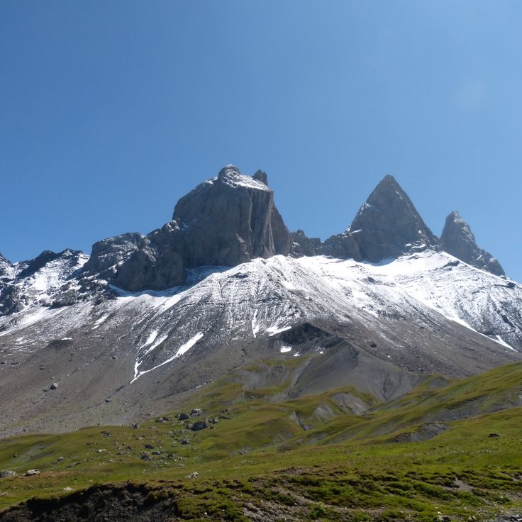
The Aiguilles d'Arves form a trio of peaks in the Arves Massif within the Dauphiné Alps. These three rock needles made of sedimentary stone reach heights between 3358 and 3514 meters. The Pointe Centrale stands at 3514 meters as the highest point, followed by the Aiguille Méridionale at 3514 meters and the Aiguille Septentrionale at 3358 meters. The massif sits on the border between the Maurienne and Romanche valleys and offers numerous climbing routes of varying difficulty levels for mountaineers.
The Cascade du Rouget drops 90 meters into the Giffre valley and ranks among the highest waterfalls in the French Alps. The waters of the Rouget stream cascade over multiple rock ledges into a forested gorge. A marked hiking trail leads from the village of Sixt-Fer-à-Cheval through forests and along the stream to the base of the falls. The Cascade du Rouget is also known as the Queen of the Alps and displays its most powerful flow during spring snowmelt.
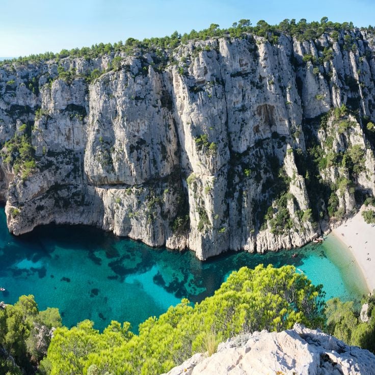
Calanque d'En-Vau is a narrow inlet surrounded by limestone cliffs rising 100 meters above sea level. The turquoise water reaches a pebble beach accessible only by boat or hiking trails. The rock walls provide natural shelter from wind and create a calm swimming area.
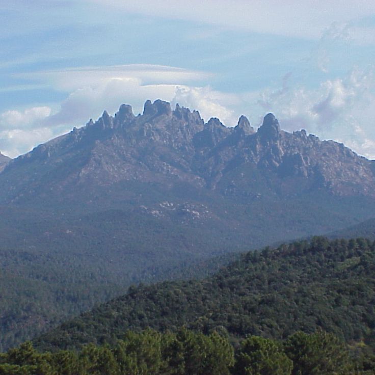
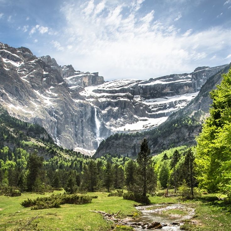
The Cirque de Gavarnie is a limestone amphitheatre formed by glacial erosion during the ice ages. The semicircular rock walls rise 1500 meters high and create a natural arena approximately 800 meters wide. The Grande Cascade de Gavarnie drops 423 meters from the upper edge in several stages, ranking among the highest waterfalls in Europe. The geological layers display sedimentary rocks from the Cretaceous period. The site sits at 1400 meters altitude within the Pyrénées National Park and forms a cross-border UNESCO World Heritage Site with Monte Perdido on the Spanish side since 1997.
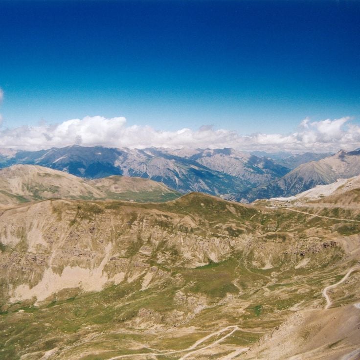
The Col de la Bonette sits at 2715 meters altitude in the Mercantour National Park, connecting the Ubaye Valley with the Tinée Valley. This high mountain road passes through alpine terrain characterized by bare rock formations and scree fields. The pass road was upgraded in the 1960s and ranks among the highest paved roads in the Alps. From the nearby Cime de la Bonette summit at 2802 meters, visitors can observe panoramic views across the southern Maritime Alps. The road typically remains open from June to October and closes during winter months due to snow.
Lac d'Allos sits at 2230 meters altitude and covers 54 hectares with a maximum depth of 48 meters. This mountain lake is the largest natural high-altitude lake in the French Alps and lies within Mercantour National Park in the Alpes-de-Haute-Provence. The lake formed through glacial erosion during the last ice age and receives water from snowmelt. The trail to Lac d'Allos starts from a parking area at 2100 meters and passes through alpine meadows with rhododendrons and edelweiss.
The Gouffre de Padirac is a natural cave in the Lot department, accessible through a vertical opening 103 meters deep. The underground network extends over 40 kilometers of galleries through which a river flows. Visitors descend into the depths and travel by boat on the subterranean waterway. The cave displays formations of stalactites and stalagmites, along with large underground chambers. The vault of the Grande Pendeloque reaches a height of 94 meters.
Mont Gerbier de Jonc is a volcanic mountain in the Ardèche department rising to 1551 meters in elevation. At its base, the Loire River, France's longest river, begins its course. The phonolitic dome formed through volcanic activity and stands today as a geological landmark of the region. Several marked hiking trails lead to the summit, offering views over the surrounding plateaus and mountains. The mountain lies within the Monts d'Ardèche Regional Natural Park and attracts hikers and geology enthusiasts.
The Gorges du Tarn form a limestone canyon in the Lozère department, carved by the erosion of the Tarn River. This gorge extends over 50 kilometers between the Causses plateaus and reaches depths of 500 meters in certain sections. Steep limestone cliffs frame the river that has cut through the rock over millennia. Several villages such as Sainte-Énimie are situated along the gorge. The Gorges provide opportunities for canoeing, hiking, and rock climbing. This geological formation belongs to the Cévennes National Park and displays characteristic karst landscapes with caves and rock formations.
Causse Méjean extends across 340 square kilometers of limestone plateau at an average elevation of 1000 meters. This high plateau lies between the Tarn and Jonte gorges and forms one of the major limestone plateaus of the Cévennes. The landscape features sparse grazing lands, sinkholes, and traditional sheep farming. Causse Méjean is part of the Cévennes National Park and was designated a UNESCO World Heritage Site as part of the Mediterranean agropastoral landscape.
The Forest of Fontainebleau covers 25000 hectares southeast of Paris and features an extensive network of trails through pine and oak woodlands. This historic forest area is characterized by distinctive sandstone formations that attract climbers from around the world. The forest served French royalty as hunting grounds for centuries and now hosts diverse flora and fauna with numerous protected species.
This regional nature park spans the Vosges Mountains and includes peaks reaching 1,424 meters, extensive coniferous forests, glacial lakes and traditional mountain villages. The protected area preserves the characteristic landscapes of the medium-altitude mountain range with high pastures, peat bogs and granite rock formations. Visitors find a dense network of hiking trails through fir and beech forests, as well as cross-country skiing opportunities in winter. The region is known for its local architecture featuring half-timbered houses and its cheese production.
The Camargue extends across the Rhône delta, forming a wetland area of 100000 hectares. This regional nature reserve includes salt marshes, rice fields and lagoons that provide habitat for numerous bird species such as flamingos. The region also supports white horses and black bulls living in semi-wild conditions. The salines, former salt extraction sites, shape the landscape alongside extensive reed beds bordering the water surfaces.
The Aiguilles de Bavella form a group of granite peaks rising in southern Corsica to a height of 1900 meters. These reddish granite towers are characterized by their distinctive needle shapes, which give the mountain range its name. The massif offers numerous climbing routes of varying difficulty levels and attracts mountaineers from across Europe. Several hiking trails cross the region, connecting the peaks with the surrounding Laricio pine forests.
The Grotte du Pech Merle was discovered in 1922 by two teenagers and contains over 700 prehistoric cave paintings from the Paleolithic period, dating back between 25,000 and 29,000 years. The cave extends over two kilometers and displays representations of mammoths, bison, horses with characteristic spotted patterns, as well as hand prints and geometric signs. The drawings were created using charcoal, ochre, and manganese oxide applied to the limestone walls. Located in the Quercy region in the commune of Cabrerets, the cave can be visited through guided tours, with visitor numbers limited to preserve the artwork.
The Cirque de Cagateille is a glacial basin in the Pyrenees surrounded by 500-meter limestone cliffs. The valley was formed during the last ice ages through glacial erosion. Several waterfalls cascade down the rock faces and feed the mountain meadows in the basin floor. Access is via hiking trails that pass through beech forests and alpine pastures.
The Réserve Naturelle des Hauts Plateaux du Vercors covers 17000 hectares on plateaus ranging from 1600 to 2300 meters in altitude. Established in 1985, this protected area is now the largest nature reserve in France. Chamois and marmots inhabit this alpine environment characterized by karst landscapes with sinkholes and underground water systems. The plateaus offer numerous hiking trails through beech forests and open areas. Winter conditions are extreme with strong winds and freezing temperatures.
The Parc national des Écrins covers 91800 hectares in the French Alps and includes 150 peaks exceeding 3000 meters in elevation along with approximately 100 glaciers. This protected area supports a rich alpine flora and fauna, including ibex, chamois, and marmots. The landscape features deep valleys, mountain lakes, and extensive coniferous forests. The park provides numerous hiking trails across different elevation zones and offers mountaineers access to several peaks above 4000 meters. Traditional mountain villages at the park's edges reflect the centuries-old relationship between people and mountains.
The Dune du Pilat rises 110 meters above sea level and extends 2.7 kilometers along the Atlantic coast. This sand dune moves between 1 and 5 meters inland each year and continuously changes shape due to wind and tides. From its summit, it offers extensive views of the ocean, the Arcachon Basin, and the pine forests beyond. The fine sand originates from the seabed and is transported to the shore by ocean currents.
The Trou de Bozouls is a horseshoe-shaped canyon formed by the erosion of the Dourdou River. The limestone cliffs of this geological formation rise approximately 100 meters high and encircle the medieval village of Bozouls. The canyon extends over 400 meters in length and offers several viewpoints from which visitors can observe the rock formations and the river course below.
The Parc national des Cévennes covers 91,000 hectares in the southern Massif Central and protects more than 2,000 plant species. This reserve includes granite peaks such as Mont Lozère and Mont Aigoual, extensive chestnut and beech forests, and numerous medieval villages built with schist stone. The national park combines Mediterranean and continental climate zones and provides habitat for mouflon sheep, deer, and over 200 bird species.
The Gouffre de l'Oeil-Doux is a circular sinkhole formed by the collapse of an underground cave. The basin measures approximately 50 meters in diameter and contains emerald green water reaching a depth of 20 meters. Steep limestone walls surround this natural formation, which is separated from the sea by a narrow rocky ridge. The surrounding area features typical Mediterranean vegetation with garrigue scrubland. Access is via a coastal walking path between Gruissan and the Massif de la Clape.
The Forêt de Brocéliande covers 7000 hectares in the heart of Brittany. This woodland consists mainly of oaks and beeches forming a dense canopy. Since medieval times, numerous legends have connected these woods to King Arthur, Merlin and the Knights of the Round Table. Visitors discover ancient stones, springs and clearings mentioned in the literary tales of the Arthurian cycle. The forest remains a place where history and mythology meet.
The Volcans d'Auvergne form a volcanic chain in the French Massif Central, comprising 80 extinct volcanoes spread over 45 kilometers. The Puy de Dôme rises to 1465 meters and dominates the landscape. The last volcanic activity occurred approximately 6000 years ago. The area offers numerous hiking trails through lava fields, crater lakes and forested volcanic slopes. The geological formations display various eruption types and volcanic structures.
The Parc à bisons de Sainte-Eulalie provides a home for a herd of 30 European bison across 200 hectares of natural terrain. The park encompasses pine and beech forests in the Lozère department, allowing visitors to observe these large mammals in their natural environment.
Cap Blanc Nez rises 134 meters above sea level and forms a prominent point on the French Channel coast. The limestone cliffs belong to the geological formation that extends along the Strait of Dover. From this headland, visitors can see the white cliffs of Dover on clear days, located just 34 kilometers away across the water. The coastal cliffs feature walking paths along the GR 120 trail that runs through northern France. The area is managed by the Conservatoire du littoral and protects the typical vegetation of limestone cliffs as well as various seabird species that nest here.
The Gorges du Fier provide access via a metal walkway positioned 25 meters above the river. The gorge reaches a depth of 40 meters and displays steep limestone walls shaped by thousands of years of erosion. The circuit extends approximately 300 meters and allows observation of geological formations and the river landscape. This natural formation is located near Annecy and remains accessible to visitors during the summer months.
The Île de Tatihou covers 28 hectares off the coast of Normandy. The island houses 17th-century military fortifications built under Vauban. At low tide, visitors can walk to the island across the seabed, while at high tide an amphibious vehicle provides transport. The island features a maritime history museum, botanical gardens and bird observation stations. The fort served for centuries as a defensive installation and later as a quarantine station.
The Réserve Naturelle de Scandola covers 1919 hectares along the western coast of Corsica, protecting both marine and terrestrial ecosystems. This reserve is characterized by its geological formations of red volcanic rock that rise directly from the Mediterranean Sea. The area includes steep cliffs, sea caves, and submarine rocks that provide habitat for numerous species. Ospreys nest on the cliff faces, while groupers and red coral inhabit the waters. The reserve is accessible only by boat and was designated a UNESCO World Heritage Site in 1983.
The underground Rivière de Labouïche is a natural cave system that can be navigated by boat for 1500 meters. This geological formation was created through limestone erosion and now forms an underground river with several galleries and chambers. Visitors traverse different cavities featuring stalactites and stalagmites while the boat glides through the river current. The interior temperature remains constant at approximately 13 degrees Celsius.
The Pic Est de Bargy rises to 2,121 meters in the Massif du Bargy within the French Alps. This limestone summit stands in a protected area known for its population of bearded vultures. These rare raptors use the rock ledges for nesting and drop bones from great heights to access the marrow inside. The area forms part of the Réserve Naturelle des Aiguilles Rouges and provides habitat for alpine fauna and flora. Hikers reach the summit via marked trails that pass through mountain pastures and karst landscapes.
These sandstone columns in the Catalan Piedmont were shaped by wind and rain erosion over thousands of years. Les Orgues d'Ille-sur-Têt rise up to 12 metres high and display clearly visible layers in reddish and grey tones, representing different sedimentary deposits from various geological epochs. The site extends over several hectares and offers marked walking trails between the formations. The mineral-rich soils date from the Tertiary period and have been continuously reshaped by thermal contrasts and rainfall.
La Roque Saint-Christophe rises as a massive limestone cliff over one hundred meters high along the Vézère River. This natural formation extends for one kilometer in length and presents five superimposed levels of caves and rock shelters. Archaeological evidence documents continuous human occupation spanning 55,000 years, from Neanderthals through the 16th century. The caves served as dwellings, workshops, and defensive positions. During the Middle Ages, a fortified settlement developed here with houses, streets, and a pulley system for goods. Today, reconstructed elements including ladders, staircases, and wooden structures enable understanding of the historical use of this extraordinary cliff dwelling. The site offers a comprehensive view of how humans adapted to and utilized this natural rock formation across millennia.
The Marais Poitevin extends over 112,000 hectares across the Vendée, Deux-Sèvres and Charente-Maritime departments. This wetland consists of a network of channels lined with ash and poplar trees. The area divides into dry marshland with agricultural fields and wet marshland with its waterways. Visitors can explore the channels by flat-bottomed boat while observing the region's characteristic flora and fauna. The area serves as habitat for numerous bird species and aquatic plants.
The Pointe du Raz rises as a steep rocky formation 72 meters above the Atlantic Ocean at the western tip of Brittany. This location marks one of the westernmost points of mainland France and provides views over the open sea and the offshore Île de Sein. The cliffs consist of granite rock shaped by wind and waves. Several walking paths run along the coast and allow access to various viewpoints overlooking the rocky coastline.
The Grotte de St Marcel d'Ardèche opens onto an extensive underground network spanning 57 kilometers in length. This cave contains several subterranean lakes, numerous stalactites and stalagmites, along with prehistoric wall paintings that testify to early human occupation of the region. The geological formations document thousands of years of limestone dissolution by water.
The Gorge de Galamus is a narrow canyon carved by the Agly River, located between the communes of Saint-Paul-de-Fenouillet and Cubières-sur-Cinoble. This geological formation cuts through limestone massifs with rock walls reaching up to 500 meters in height. A path carved into the rock follows the river course and allows hikers to traverse the gorge. The Chapel of Saint-Antoine de Galamus, a 17th-century hermitage built into the cliff face, stands at the entrance to the gorge and is accessible via steps cut into the stone.
The Vallée d'Ossau extends through the western Pyrenees, following the course of the Gave d'Ossau river. The valley provides access to several mountain lakes, including Lac d'Ayous and Lac de Bious-Artigues. Hiking trails cross alpine meadows and forests that reach toward the peaks. Traditional villages in the region maintain the pastoral architecture characteristic of the Pyrenees. During winter months, the higher elevations serve as starting points for snowshoeing and ski touring.
Rocamadour is a medieval town built on a 150-metre limestone cliff. The settlement extends across several levels and includes seven religious buildings, among them the Chapelle Notre-Dame housing a 12th-century Black Madonna. The 14th-century château sits atop the town and provides access to the fortifications. Steep lanes and staircases connect the different levels of the town, which has been a major pilgrimage site since medieval times.
Parc national de la Vanoise was established in 1963 as France's first national park, covering 53,500 hectares in the Savoie Alps. The territory includes 107 peaks exceeding 3,000 meters in elevation, including Grande Casse at 3,855 meters. The park protects alpine ecosystems with glaciers, high-altitude pastures and valleys. Wildlife includes ibex, chamois and marmots. The trail network provides access to different elevation zones from coniferous forests to moraine landscapes.
The Aiguilles d'Arves form a trio of peaks in the Arves Massif within the Dauphiné Alps. These three rock needles made of sedimentary stone reach heights between 3358 and 3514 meters. The Pointe Centrale stands at 3514 meters as the highest point, followed by the Aiguille Méridionale at 3514 meters and the Aiguille Septentrionale at 3358 meters. The massif sits on the border between the Maurienne and Romanche valleys and offers numerous climbing routes of varying difficulty levels for mountaineers.
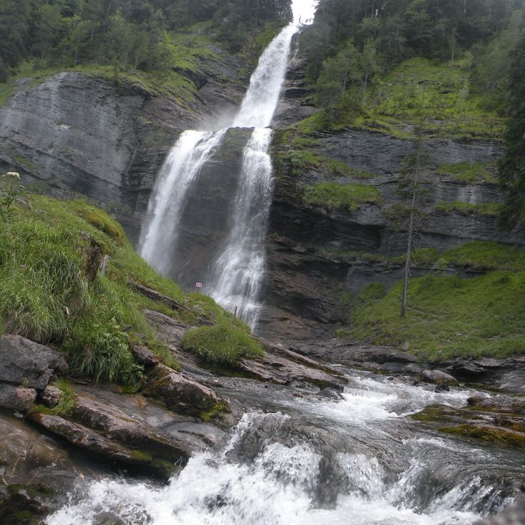
The Cascade du Rouget drops 90 meters into the Giffre valley and ranks among the highest waterfalls in the French Alps. The waters of the Rouget stream cascade over multiple rock ledges into a forested gorge. A marked hiking trail leads from the village of Sixt-Fer-à-Cheval through forests and along the stream to the base of the falls. The Cascade du Rouget is also known as the Queen of the Alps and displays its most powerful flow during spring snowmelt.
Calanque d'En-Vau is a narrow inlet surrounded by limestone cliffs rising 100 meters above sea level. The turquoise water reaches a pebble beach accessible only by boat or hiking trails. The rock walls provide natural shelter from wind and create a calm swimming area.
The Cirque de Gavarnie is a limestone amphitheatre formed by glacial erosion during the ice ages. The semicircular rock walls rise 1500 meters high and create a natural arena approximately 800 meters wide. The Grande Cascade de Gavarnie drops 423 meters from the upper edge in several stages, ranking among the highest waterfalls in Europe. The geological layers display sedimentary rocks from the Cretaceous period. The site sits at 1400 meters altitude within the Pyrénées National Park and forms a cross-border UNESCO World Heritage Site with Monte Perdido on the Spanish side since 1997.
The Col de la Bonette sits at 2715 meters altitude in the Mercantour National Park, connecting the Ubaye Valley with the Tinée Valley. This high mountain road passes through alpine terrain characterized by bare rock formations and scree fields. The pass road was upgraded in the 1960s and ranks among the highest paved roads in the Alps. From the nearby Cime de la Bonette summit at 2802 meters, visitors can observe panoramic views across the southern Maritime Alps. The road typically remains open from June to October and closes during winter months due to snow.
Lac d'Allos sits at 2230 meters altitude and covers 54 hectares with a maximum depth of 48 meters. This mountain lake is the largest natural high-altitude lake in the French Alps and lies within Mercantour National Park in the Alpes-de-Haute-Provence. The lake formed through glacial erosion during the last ice age and receives water from snowmelt. The trail to Lac d'Allos starts from a parking area at 2100 meters and passes through alpine meadows with rhododendrons and edelweiss.
The Gouffre de Padirac is a natural cave in the Lot department, accessible through a vertical opening 103 meters deep. The underground network extends over 40 kilometers of galleries through which a river flows. Visitors descend into the depths and travel by boat on the subterranean waterway. The cave displays formations of stalactites and stalagmites, along with large underground chambers. The vault of the Grande Pendeloque reaches a height of 94 meters.
Mont Gerbier de Jonc is a volcanic mountain in the Ardèche department rising to 1551 meters in elevation. At its base, the Loire River, France's longest river, begins its course. The phonolitic dome formed through volcanic activity and stands today as a geological landmark of the region. Several marked hiking trails lead to the summit, offering views over the surrounding plateaus and mountains. The mountain lies within the Monts d'Ardèche Regional Natural Park and attracts hikers and geology enthusiasts.
The Gorges du Tarn form a limestone canyon in the Lozère department, carved by the erosion of the Tarn River. This gorge extends over 50 kilometers between the Causses plateaus and reaches depths of 500 meters in certain sections. Steep limestone cliffs frame the river that has cut through the rock over millennia. Several villages such as Sainte-Énimie are situated along the gorge. The Gorges provide opportunities for canoeing, hiking, and rock climbing. This geological formation belongs to the Cévennes National Park and displays characteristic karst landscapes with caves and rock formations.
Causse Méjean extends across 340 square kilometers of limestone plateau at an average elevation of 1000 meters. This high plateau lies between the Tarn and Jonte gorges and forms one of the major limestone plateaus of the Cévennes. The landscape features sparse grazing lands, sinkholes, and traditional sheep farming. Causse Méjean is part of the Cévennes National Park and was designated a UNESCO World Heritage Site as part of the Mediterranean agropastoral landscape.
The Forest of Fontainebleau covers 25000 hectares southeast of Paris and features an extensive network of trails through pine and oak woodlands. This historic forest area is characterized by distinctive sandstone formations that attract climbers from around the world. The forest served French royalty as hunting grounds for centuries and now hosts diverse flora and fauna with numerous protected species.
This regional nature park spans the Vosges Mountains and includes peaks reaching 1,424 meters, extensive coniferous forests, glacial lakes and traditional mountain villages. The protected area preserves the characteristic landscapes of the medium-altitude mountain range with high pastures, peat bogs and granite rock formations. Visitors find a dense network of hiking trails through fir and beech forests, as well as cross-country skiing opportunities in winter. The region is known for its local architecture featuring half-timbered houses and its cheese production.
The Camargue extends across the Rhône delta, forming a wetland area of 100000 hectares. This regional nature reserve includes salt marshes, rice fields and lagoons that provide habitat for numerous bird species such as flamingos. The region also supports white horses and black bulls living in semi-wild conditions. The salines, former salt extraction sites, shape the landscape alongside extensive reed beds bordering the water surfaces.
The Aiguilles de Bavella form a group of granite peaks rising in southern Corsica to a height of 1900 meters. These reddish granite towers are characterized by their distinctive needle shapes, which give the mountain range its name. The massif offers numerous climbing routes of varying difficulty levels and attracts mountaineers from across Europe. Several hiking trails cross the region, connecting the peaks with the surrounding Laricio pine forests.
The Grotte du Pech Merle was discovered in 1922 by two teenagers and contains over 700 prehistoric cave paintings from the Paleolithic period, dating back between 25,000 and 29,000 years. The cave extends over two kilometers and displays representations of mammoths, bison, horses with characteristic spotted patterns, as well as hand prints and geometric signs. The drawings were created using charcoal, ochre, and manganese oxide applied to the limestone walls. Located in the Quercy region in the commune of Cabrerets, the cave can be visited through guided tours, with visitor numbers limited to preserve the artwork.
The Cirque de Cagateille is a glacial basin in the Pyrenees surrounded by 500-meter limestone cliffs. The valley was formed during the last ice ages through glacial erosion. Several waterfalls cascade down the rock faces and feed the mountain meadows in the basin floor. Access is via hiking trails that pass through beech forests and alpine pastures.
The Réserve Naturelle des Hauts Plateaux du Vercors covers 17000 hectares on plateaus ranging from 1600 to 2300 meters in altitude. Established in 1985, this protected area is now the largest nature reserve in France. Chamois and marmots inhabit this alpine environment characterized by karst landscapes with sinkholes and underground water systems. The plateaus offer numerous hiking trails through beech forests and open areas. Winter conditions are extreme with strong winds and freezing temperatures.
The Parc national des Écrins covers 91800 hectares in the French Alps and includes 150 peaks exceeding 3000 meters in elevation along with approximately 100 glaciers. This protected area supports a rich alpine flora and fauna, including ibex, chamois, and marmots. The landscape features deep valleys, mountain lakes, and extensive coniferous forests. The park provides numerous hiking trails across different elevation zones and offers mountaineers access to several peaks above 4000 meters. Traditional mountain villages at the park's edges reflect the centuries-old relationship between people and mountains.
The Dune du Pilat rises 110 meters above sea level and extends 2.7 kilometers along the Atlantic coast. This sand dune moves between 1 and 5 meters inland each year and continuously changes shape due to wind and tides. From its summit, it offers extensive views of the ocean, the Arcachon Basin, and the pine forests beyond. The fine sand originates from the seabed and is transported to the shore by ocean currents.
The Trou de Bozouls is a horseshoe-shaped canyon formed by the erosion of the Dourdou River. The limestone cliffs of this geological formation rise approximately 100 meters high and encircle the medieval village of Bozouls. The canyon extends over 400 meters in length and offers several viewpoints from which visitors can observe the rock formations and the river course below.
The Parc national des Cévennes covers 91,000 hectares in the southern Massif Central and protects more than 2,000 plant species. This reserve includes granite peaks such as Mont Lozère and Mont Aigoual, extensive chestnut and beech forests, and numerous medieval villages built with schist stone. The national park combines Mediterranean and continental climate zones and provides habitat for mouflon sheep, deer, and over 200 bird species.
The Gouffre de l'Oeil-Doux is a circular sinkhole formed by the collapse of an underground cave. The basin measures approximately 50 meters in diameter and contains emerald green water reaching a depth of 20 meters. Steep limestone walls surround this natural formation, which is separated from the sea by a narrow rocky ridge. The surrounding area features typical Mediterranean vegetation with garrigue scrubland. Access is via a coastal walking path between Gruissan and the Massif de la Clape.
The Forêt de Brocéliande covers 7000 hectares in the heart of Brittany. This woodland consists mainly of oaks and beeches forming a dense canopy. Since medieval times, numerous legends have connected these woods to King Arthur, Merlin and the Knights of the Round Table. Visitors discover ancient stones, springs and clearings mentioned in the literary tales of the Arthurian cycle. The forest remains a place where history and mythology meet.
The Volcans d'Auvergne form a volcanic chain in the French Massif Central, comprising 80 extinct volcanoes spread over 45 kilometers. The Puy de Dôme rises to 1465 meters and dominates the landscape. The last volcanic activity occurred approximately 6000 years ago. The area offers numerous hiking trails through lava fields, crater lakes and forested volcanic slopes. The geological formations display various eruption types and volcanic structures.
The Parc à bisons de Sainte-Eulalie provides a home for a herd of 30 European bison across 200 hectares of natural terrain. The park encompasses pine and beech forests in the Lozère department, allowing visitors to observe these large mammals in their natural environment.
Cap Blanc Nez rises 134 meters above sea level and forms a prominent point on the French Channel coast. The limestone cliffs belong to the geological formation that extends along the Strait of Dover. From this headland, visitors can see the white cliffs of Dover on clear days, located just 34 kilometers away across the water. The coastal cliffs feature walking paths along the GR 120 trail that runs through northern France. The area is managed by the Conservatoire du littoral and protects the typical vegetation of limestone cliffs as well as various seabird species that nest here.
The Gorges du Fier provide access via a metal walkway positioned 25 meters above the river. The gorge reaches a depth of 40 meters and displays steep limestone walls shaped by thousands of years of erosion. The circuit extends approximately 300 meters and allows observation of geological formations and the river landscape. This natural formation is located near Annecy and remains accessible to visitors during the summer months.
The Île de Tatihou covers 28 hectares off the coast of Normandy. The island houses 17th-century military fortifications built under Vauban. At low tide, visitors can walk to the island across the seabed, while at high tide an amphibious vehicle provides transport. The island features a maritime history museum, botanical gardens and bird observation stations. The fort served for centuries as a defensive installation and later as a quarantine station.
The Réserve Naturelle de Scandola covers 1919 hectares along the western coast of Corsica, protecting both marine and terrestrial ecosystems. This reserve is characterized by its geological formations of red volcanic rock that rise directly from the Mediterranean Sea. The area includes steep cliffs, sea caves, and submarine rocks that provide habitat for numerous species. Ospreys nest on the cliff faces, while groupers and red coral inhabit the waters. The reserve is accessible only by boat and was designated a UNESCO World Heritage Site in 1983.
The underground Rivière de Labouïche is a natural cave system that can be navigated by boat for 1500 meters. This geological formation was created through limestone erosion and now forms an underground river with several galleries and chambers. Visitors traverse different cavities featuring stalactites and stalagmites while the boat glides through the river current. The interior temperature remains constant at approximately 13 degrees Celsius.
The Pic Est de Bargy rises to 2,121 meters in the Massif du Bargy within the French Alps. This limestone summit stands in a protected area known for its population of bearded vultures. These rare raptors use the rock ledges for nesting and drop bones from great heights to access the marrow inside. The area forms part of the Réserve Naturelle des Aiguilles Rouges and provides habitat for alpine fauna and flora. Hikers reach the summit via marked trails that pass through mountain pastures and karst landscapes.
These sandstone columns in the Catalan Piedmont were shaped by wind and rain erosion over thousands of years. Les Orgues d'Ille-sur-Têt rise up to 12 metres high and display clearly visible layers in reddish and grey tones, representing different sedimentary deposits from various geological epochs. The site extends over several hectares and offers marked walking trails between the formations. The mineral-rich soils date from the Tertiary period and have been continuously reshaped by thermal contrasts and rainfall.
La Roque Saint-Christophe rises as a massive limestone cliff over one hundred meters high along the Vézère River. This natural formation extends for one kilometer in length and presents five superimposed levels of caves and rock shelters. Archaeological evidence documents continuous human occupation spanning 55,000 years, from Neanderthals through the 16th century. The caves served as dwellings, workshops, and defensive positions. During the Middle Ages, a fortified settlement developed here with houses, streets, and a pulley system for goods. Today, reconstructed elements including ladders, staircases, and wooden structures enable understanding of the historical use of this extraordinary cliff dwelling. The site offers a comprehensive view of how humans adapted to and utilized this natural rock formation across millennia.
The Marais Poitevin extends over 112,000 hectares across the Vendée, Deux-Sèvres and Charente-Maritime departments. This wetland consists of a network of channels lined with ash and poplar trees. The area divides into dry marshland with agricultural fields and wet marshland with its waterways. Visitors can explore the channels by flat-bottomed boat while observing the region's characteristic flora and fauna. The area serves as habitat for numerous bird species and aquatic plants.
The Pointe du Raz rises as a steep rocky formation 72 meters above the Atlantic Ocean at the western tip of Brittany. This location marks one of the westernmost points of mainland France and provides views over the open sea and the offshore Île de Sein. The cliffs consist of granite rock shaped by wind and waves. Several walking paths run along the coast and allow access to various viewpoints overlooking the rocky coastline.
The Grotte de St Marcel d'Ardèche opens onto an extensive underground network spanning 57 kilometers in length. This cave contains several subterranean lakes, numerous stalactites and stalagmites, along with prehistoric wall paintings that testify to early human occupation of the region. The geological formations document thousands of years of limestone dissolution by water.
The Gorge de Galamus is a narrow canyon carved by the Agly River, located between the communes of Saint-Paul-de-Fenouillet and Cubières-sur-Cinoble. This geological formation cuts through limestone massifs with rock walls reaching up to 500 meters in height. A path carved into the rock follows the river course and allows hikers to traverse the gorge. The Chapel of Saint-Antoine de Galamus, a 17th-century hermitage built into the cliff face, stands at the entrance to the gorge and is accessible via steps cut into the stone.
The Vallée d'Ossau extends through the western Pyrenees, following the course of the Gave d'Ossau river. The valley provides access to several mountain lakes, including Lac d'Ayous and Lac de Bious-Artigues. Hiking trails cross alpine meadows and forests that reach toward the peaks. Traditional villages in the region maintain the pastoral architecture characteristic of the Pyrenees. During winter months, the higher elevations serve as starting points for snowshoeing and ski touring.
Rocamadour is a medieval town built on a 150-metre limestone cliff. The settlement extends across several levels and includes seven religious buildings, among them the Chapelle Notre-Dame housing a 12th-century Black Madonna. The 14th-century château sits atop the town and provides access to the fortifications. Steep lanes and staircases connect the different levels of the town, which has been a major pilgrimage site since medieval times.
Parc national de la Vanoise was established in 1963 as France's first national park, covering 53,500 hectares in the Savoie Alps. The territory includes 107 peaks exceeding 3,000 meters in elevation, including Grande Casse at 3,855 meters. The park protects alpine ecosystems with glaciers, high-altitude pastures and valleys. Wildlife includes ibex, chamois and marmots. The trail network provides access to different elevation zones from coniferous forests to moraine landscapes.
The Aiguilles d'Arves form a trio of peaks in the Arves Massif within the Dauphiné Alps. These three rock needles made of sedimentary stone reach heights between 3358 and 3514 meters. The Pointe Centrale stands at 3514 meters as the highest point, followed by the Aiguille Méridionale at 3514 meters and the Aiguille Septentrionale at 3358 meters. The massif sits on the border between the Maurienne and Romanche valleys and offers numerous climbing routes of varying difficulty levels for mountaineers.
The Cascade du Rouget drops 90 meters into the Giffre valley and ranks among the highest waterfalls in the French Alps. The waters of the Rouget stream cascade over multiple rock ledges into a forested gorge. A marked hiking trail leads from the village of Sixt-Fer-à-Cheval through forests and along the stream to the base of the falls. The Cascade du Rouget is also known as the Queen of the Alps and displays its most powerful flow during spring snowmelt.
Calanque d'En-Vau is a narrow inlet surrounded by limestone cliffs rising 100 meters above sea level. The turquoise water reaches a pebble beach accessible only by boat or hiking trails. The rock walls provide natural shelter from wind and create a calm swimming area.
The Cirque de Gavarnie is a limestone amphitheatre formed by glacial erosion during the ice ages. The semicircular rock walls rise 1500 meters high and create a natural arena approximately 800 meters wide. The Grande Cascade de Gavarnie drops 423 meters from the upper edge in several stages, ranking among the highest waterfalls in Europe. The geological layers display sedimentary rocks from the Cretaceous period. The site sits at 1400 meters altitude within the Pyrénées National Park and forms a cross-border UNESCO World Heritage Site with Monte Perdido on the Spanish side since 1997.
The Col de la Bonette sits at 2715 meters altitude in the Mercantour National Park, connecting the Ubaye Valley with the Tinée Valley. This high mountain road passes through alpine terrain characterized by bare rock formations and scree fields. The pass road was upgraded in the 1960s and ranks among the highest paved roads in the Alps. From the nearby Cime de la Bonette summit at 2802 meters, visitors can observe panoramic views across the southern Maritime Alps. The road typically remains open from June to October and closes during winter months due to snow.