Enable Location

We need your location to show you interesting places around you

Discover nearby places

Find interesting locations and hidden gems around you

Precise directions

Get accurate directions and distances to places

Your location is never shared with other users. It's only used when you tap the location button.

Rue d'Alsace

Log in to your account

Join the adventure

Create your free account and start exploring (like 60k+ others)

We will send you a code to connect

or
Continue with Google
Continue with Apple
By continuing, you accept our Terms and Conditions and our Privacy Policy

Check your inbox

We've sent a pincode in your inbox. Please enter the code below.

Rue d'Alsace

Rue d'Alsace, Pedestrian street in central Angers, France

Description

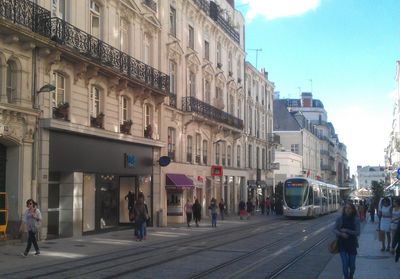
Rue d'Alsace connects Boulevard du Maréchal-Foch to Place du Ralliement and is a wide pedestrian street with a tram line running through its center. Shops and cafes line both sides, creating a busy shopping area where people move freely between stores.

History

After the city fortifications were torn down in 1845, this street was built to connect Boulevard du Maréchal-Foch with Place du Ralliement. It became a commercial hub over time and was completely reshaped when the tram arrived in 2011.

Culture

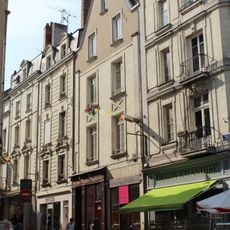
The street is named after the French region of Alsace and carries that historical connection in its identity. You can see this reflected in how locals and visitors move through and use this shopping corridor as a central gathering place.

Practical

The street is flat and easy to walk, with wide sidewalks and occasional seating areas to rest. The tram line in the center is well marked and keeps pedestrians separated from the tracks, though you do need to watch when crossing.

Did you know?

The tram runs directly down the middle of the pedestrian walkway rather than on a separate track, which is unusual for French shopping streets. This arrangement required careful planning to keep both tram riders and walkers safe and comfortable sharing the same space.

Location
Shares border with
boulevard du Maréchal-Foch
GPS coordinates
47.47040,-0.55065
Latest update
December 14, 2025 18:20

AroundUs brings together thousands of curated places, local tips, and hidden gems, enriched daily by 60,000 contributors worldwide. Discover all places nearby (Angers).

« Rue d'Alsace - Pedestrian street in central Angers, France » is provided by Around Us (aroundus.com). Images and texts are derived from Wikimedia project under a Creative Commons license. You are allowed to copy, distribute, and modify copies of this page, under the conditions set by the license, as long as this note is clearly visible.

Discover hidden gems everywhere you go!

From secret cafés to breathtaking viewpoints, skip the crowded tourist spots and find places that match your style. Our app makes it easy with voice search, smart filtering, route optimization, and insider tips from travelers worldwide. Download now for the complete mobile experience.

Around Us App Screenshot

A unique approach to discovering new places

Le Figaro

All the places worth exploring

France Info

A tailor-made excursion in just a few clicks

20 Minutes

Around Us
Travel Guide & Maps
Download

Send to your phone

QR Code
1

Open the camera app on your mobile.

2

Point at the QR code with your camera. A notification will appear.

3

Tap the notification to open the link.