Morne Mazeau, Mountain summit in Deshaies, Guadeloupe, France
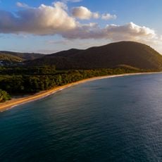
Morne Mazeau is a summit on the border of Deshaies and Sainte-Rose on Basse-Terre, Guadeloupe, rising to 613 metres. Its north-east flank holds the source of the Nogent river, its north flank that of the Deshaies river, and its southern ravines feed the grand arm of the Ferry river. A road reaches the top, and a seismic station with two sensors sits in a 2-metre-deep cavity.
Morne Mazeau lies on the boundary between Deshaies and Sainte-Rose, and its summit now hosts the seismic station of Basse-Terre. Two sensors sit in a cavity two metres deep to shield them from temperature swings: a very broadband seismometer and an accelerometer that records strong movements without saturating. An antenna linked to a receiver logs satellite signals, measuring ground deformation precisely.
The summit lies on the boundary between Deshaies and Sainte-Rose, and the roads climbing it from the north-east and the west are used as training routes by cyclists and as descents by mountain bikers. Several marked "traces" also cross the morne.
Morne Mazeau can be reached by road: one section climbs from the north-east, the other from the west. These roads are regularly used as training routes by cyclists and as descents by mountain bikers, so expect two-wheeled traffic. The summit lies on the boundary between Deshaies and Sainte-Rose, and several marked "traces" cross the massif.
A seismic monitoring network with sensors housed in protected locations continuously records ground movements and tectonic shifts. This observation system provides valuable data about the geological activity beneath the Caribbean islands.
The community of curious travelers
AroundUs brings together thousands of curated places, local tips, and hidden gems, enriched daily by 94,458 contributors worldwide.