Suc de Montfol, Mountain summit in Ardèche, France
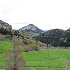
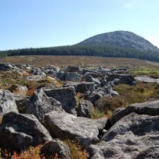
Suc de Montfol is a rounded, slightly flattened summit on the Ardèche plateau, reaching 1,594 m, close to Mont Mézenc, the highest point of Ardèche at 1,753 m. Its upper slopes are grass with many grey rock outcrops and patches of pale stone, while a band of dark coniferous forest wraps around the lower slope above the fields.
Suc de Montfol lies on the Ardèche plateau, close to Mont Mézenc, the department's highest point at 1,753 metres. The summit rises about 218 metres above the surrounding terrain, and its base spans roughly 5.2 kilometres. It stands 7.7 kilometres south of Mont Mézenc Sud, near Le Monastier-sur-Gazeille, about 16 kilometres to the north.
The name "suc" is the local Auvergne and Vivarais term for a volcanic dome or cone, so the summit's name records its volcanic origin. It lies on the Ardèche plateau near Mont Mézenc, the department's highest point at 1,753 metres, and walkers on the upper grassy slopes pass numerous grey rock outcrops.
Several hiking trails lead to the summit, with most routes taking between two to four hours depending on where you start. The most accessible approach is from nearby villages, where marked paths guide you up to the peak.
Among 9,119 peaks in the Massif Central, Suc de Montfol ranks as the 58th highest, featuring a prominence of 121 meters.
The community of curious travelers
AroundUs brings together thousands of curated places, local tips, and hidden gems, enriched daily by 92,840 contributors worldwide.