Pointe Licciola, Mountain summit at 445 meters in Corsica, France
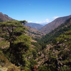
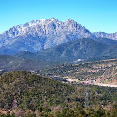
Pointe Licciola is a summit at 445 meters situated between the Paglia Orba and Cinto massifs, featuring steep rocky slopes on its flanks. From the top, you can see across the Mediterranean landscape and spot the distinctive rock formations in the surrounding peaks.
The mountain sits on an ancient route called Niolu-Falasorma where herders moved their flocks for centuries between high summer pastures and lower winter grounds. This seasonal practice shaped the mountain landscape and the paths that remain visible to this day.
Mountain herders have used this summit as a landmark for centuries during their seasonal migrations with flocks across the region. Local hiking groups maintain the marked routes with red and white paint, keeping these traditional passages alive for visitors who follow them.
The trail to the summit starts at Col de Vergio and follows a path of about 6 kilometers that crosses the Golo River and passes by the Radule pastures. Sturdy hiking boots and a map are helpful, since the route becomes increasingly steep and rocky as you climb.
On clear days, you can spot the Tafunatu rock formation through the Sponde ravine from the summit, a rare geological feature with a natural hole running through it. This unusual landmark is easy to miss at first glance, but it adds a special detail to the view across the mountains.
The community of curious travelers
AroundUs brings together thousands of curated places, local tips, and hidden gems, enriched daily by 60,000 contributors worldwide.