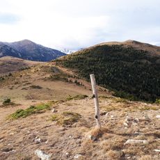
Puig de l'Estela, Mountain summit in Pyrenees, France
Puig de l'Estela is a mountain summit in the French Pyrenees standing at 1715 meters elevation. It sits between the towns of Cortsaví, La Bastida, and Vallmanya in this alpine region.
The summit was part of a major survey project in the late 1700s that determined the length of a meter. Scientists used triangulation points stretching from Dunkirk to Barcelona, including this location in their measurements.
The peak is recognized among hikers in the region and serves as an important reference point for local communities. Its location and name carry meaning in the mountain landscape shared by several valleys.
Several marked hiking trails lead to the summit, with main access points from the towns of Cortsaví and La Bastida. Visitors should bring proper hiking gear and check weather conditions before heading out.
The summit marks the boundary between three distinct French regions: Conflent to the northwest, Vallespir to the south, and Rosselló to the northeast. This position makes it a natural meeting point where different landscapes converge.
The community of curious travelers
AroundUs brings together thousands of curated places, local tips, and hidden gems, enriched daily by 60,000 contributors worldwide.