Chest opened
+${chestReward.xp} XP
Explorer
NOUVEAU ×${chestReward.collectible.quantity}
tapez pour fermer

See the monuments around you in AR Open chests in the app

Around Us is built for your phone — point your camera at the streets and discover the monuments and places around you in augmented reality. Around Us is built for your phone — chests unlock when you walk, explore and capture nearby places.

•

Enable Location

We need your location to show you interesting places around you

Discover nearby places

Find interesting locations and hidden gems around you

Precise directions

Get accurate directions and distances to places

Your location is never shared with other users. It's only used when you tap the location button.

Malin Head

Log in to your account

Start exploring — it's free

Trusted by 92,598 travelers worldwide

Continue with Google
Continue with Apple
or

We will send you a code to connect

By continuing, you accept our Terms and Conditions and our Privacy Policy

Check your inbox

We've sent a pincode in your inbox. Please enter the code below.

Malin Head

Malin Head, Coastal headland in County Donegal, Ireland

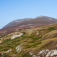
Malin Head is the northernmost point of mainland Ireland, a broad headland in County Donegal whose grassy plateau ends in steep, dark rock faces fractured into vertical columns. The northern tip is called Dunalderagh, at latitude 55.38ºN, about 16 km north of Malin village. Small white birds can be seen on the rock face.

During World War II the British government installed radio direction finding equipment at this cape to monitor North Atlantic naval activities. This military use shaped the site for several years.

Malin Head gives its name to the Malin sea area, whose conditions are read in the BBC Shipping Forecast, and its weather station is one of 22 whose reports are broadcast there. In autumn, birdwatchers gather on the headland to watch gannets, shearwaters, skuas and auks on their southward migration; black-browed albatross and fea's petrel have been recorded. Basking sharks and a resident pod of bottle-nosed dolphins are watched from the cape.

Malin Head lies about 16 km north of Malin village on the Inishowen peninsula, reached by local roads; the northern tip is Dunalderagh at 55.38ºN. High winds and storms occur for much of the year, so check conditions before walking the exposed cliff tops. The 1805 tower on Altnadarrow, or Tower Hill, and the nearby '80 EIRE' stone marker are the main landmarks to orient by.

The highest wind speed recorded at Malin Head's weather station reached 181.5 km/h on 16 September 1961, when Hurricane Debbie caused damage along Ireland's west coast. The station's reports are among 22 broadcast in the BBC Shipping Forecast.

The community of curious travelers

AroundUs brings together thousands of curated places, local tips, and hidden gems, enriched daily by 92,598 contributors worldwide.


Start exploring
GPS coordinates
55.38081,-7.37000
Latest update
October 24, 2026 13:22
Hiking and history: exploring the real Irish landscapes

Between rocky shores and mountains, Ireland offers paths that lead to forgotten monasteries and sleepy villages.

Reviews
Share your experience

No review yet

Discussions
Start a discussion...

No discussion yet

« Malin Head - Coastal headland in County Donegal, Ireland » is provided by Around Us (aroundus.com). Images and texts are derived from Wikimedia project under a Creative Commons license. You are allowed to copy, distribute, and modify copies of this page, under the conditions set by the license, as long as this note is clearly visible.

Discover hidden gems everywhere you go!

From secret cafés to breathtaking viewpoints, skip the crowded tourist spots and find places that match your style. Our app makes it easy with voice search, smart filtering, route optimization, and insider tips from travelers worldwide. Download now for the complete mobile experience.

Around Us App Screenshot
❝

A unique approach to discovering new places❞

— Le Figaro

❝

All the places worth exploring❞

— France Info

❝

A tailor-made excursion in just a few clicks❞

— 20 Minutes

Around Us
Travel Guide & Maps
Download

Send to your phone

QR Code
1

Open the camera app on your mobile.

2

Point at the QR code with your camera. A notification will appear.

3

Tap the notification to open the link.