Monte Tudaio, Mountain peak in Vigo di Cadore, Italy
Monte Tudaio is a 2,140-metre peak in the municipality of Vigo di Cadore, Belluno, forming one of the first foothills of the Dolomites. Its summit holds the ruins of Forte Tudaio, among which several antennas stand. Two routes start from the Pino Solitario car park at about 878 metres in Piniè: a military road with 35 hairpin bends on the eastern slope, and a steep, poorly marked trail on the south side with three points requiring via ferrata kit.
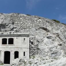
Forte Tudaio was built by the Italian army in the years of World War I, just below the 2,140 m summit of Monte Tudaio in the municipality of Vigo di Cadore. It was meant to stop Austro-Hungarian troops advancing along the Val d'Ansiei or from the Centro Cadore. Only ruins remain today, with several antennas standing among the rubble.
The summit area holds the ruins of Forte Tudaio, an Italian fort built for World War I, and several antennas now stand among the rubble. Hikers who reach the top walk among these remains; the site is not a staffed refuge and no shelter dedicated to a mountaineer is documented in the sources.
Both routes start from the car park by the Pino Solitario restaurant at about 878 m in Piniè, Vigo di Cadore. The classic route follows the old military road up the eastern slope through 35 hairpin bends, 8.2 km round trip with 1,260 m of ascent, taking 2 to 4 hours. The southern path is steep and poorly marked from the start and has three points where a via ferrata kit is needed.
A network of military tunnels runs through the mountain and was designed to hide artillery and provide strategic observation points. Some of these underground structures remain visible today, showing the sophisticated defensive methods of that era.
The community of curious travelers
AroundUs brings together thousands of curated places, local tips, and hidden gems, enriched daily by 94,423 contributors worldwide.