Rocca delle Penne, Mountain summit between Piedmont and Liguria, Italy
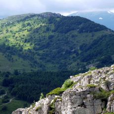
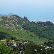
Rocca delle Penne is a 1,501 m mountain of the Ligurian Prealps, on the border between the province of Imperia in Liguria and the province of Cuneo in Piedmont. It is the highest point of the Dorsale della Rocca delle Penne, the ridge that runs south-east from Monte della Guardia and separates the Arroscia valley from the Pennavaire valley. The summit is separated from Monte della Guardia by the Colle di Caprauna (1,379 m) and from Rocca Tramontina (1,495 m) by a saddle at 1,470 m.
The mountain lies on the border between the province of Imperia in Liguria and the province of Cuneo in Piedmont. In the SOIUSA classification it gives its name to the Dorsale della Rocca delle Penne, the ridge that leaves the main Alpine chain at Monte della Guardia and runs south-east between the Arroscia and Pennavaire valleys. The name may come from the Celtic root penn, meaning peak.
The name comes from the Celtic root penn, meaning peak or summit, which also appears in the name of the Pennavaire valley below. The ridge that carries the mountain takes its name from the peak: the Dorsale della Rocca delle Penne, which runs south-east from Monte della Guardia and separates the Arroscia and Pennavaire valleys.
Hikers can reach the summit through several routes that depart from Colle di Caprauna and follow ridge paths. The trails require good stamina and sure footing on rocky ground.
The name likely comes from the Celtic root penn, meaning peak or summit, which also appears in the name of the Pennavaire valley below. The mountain gives its name to the Dorsale della Rocca delle Penne, the ridge that separates the Arroscia and Pennavaire valleys. A nearby summit, Rocca Tramontina at 1,495 m, is separated from it by a saddle at 1,470 m.
The community of curious travelers
AroundUs brings together thousands of curated places, local tips, and hidden gems, enriched daily by 94,536 contributors worldwide.