Taldyk Pass, Mountain pass in Alay Mountains, Kyrgyzstan
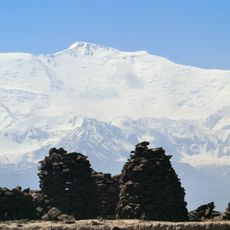
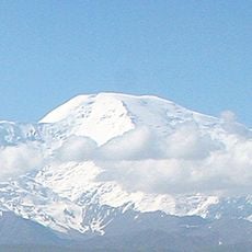
Taldyk Pass is a mountain crossing through the Alay Mountains at 3,615 meters elevation, linking the Gulcha River region to the Alai Valley in southern Kyrgyzstan. This passage forms part of a key North-South route connecting different valleys and settlements across the region.
Russian forces built the first cart path in 1876 under General Abramov's command as a military communication line to the Alay Valley. The route later developed into an important trade connection between different regions.
The monument to construction manager Yuri M. Grushko stands at the pass, marking the engineering achievements of the 1930s road development project.
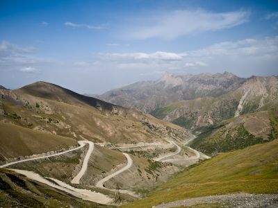
The pass is accessible year-round via the M41 highway, with a paved road running between Ak-Bosogo and Sary-Tash. The northern side is steep and winding, making travel easier during warmer months.
The northern approach includes fourteen sharp hairpin turns that create a challenging driving experience while offering stunning views of the surrounding mountains. This winding section is known among motorcyclists who seek the technical challenge.
Elevation above the sea: 3,615 m
GPS coordinates: 39.76500,73.16833
Latest update: December 6, 2025 17:44
Lenin Peak
52.7 kmLenin glacier
44.7 km
Papan Reservoir
70.4 km
Abshir Ata Waterfall
81.7 km
Ajidaar-Unkyur
81.3 km
Korzhenevsky Glacier
40.1 km
Dangi Canyon
74 km
Dzerzhinsky Peak
57.1 km
Lednik Achyk-Suu
74.4 km
Lednik Atdzhaylo
40.9 km
Rodnik Chogaden
66.3 km
Rodnik Zor-Bulak
83.3 km
Rodnik Kur-Bulak
58.6 km
Rodnik Kayragach-Mazar
81.6 km
Rodnik Chong-Tash-Tër
33.7 km
Rodnik Ak-Bulak (tubud sa Kirgistan)
69.4 km
Rodnik Chakman
76.2 km
Rodnik Kyzyl-Bulak (tubud sa Kirgistan)
83 km
Rodnik Kyrchyn
78.9 km
Rodnik Aygyr-Bulak
79.4 km
Rodnik Uzuk-Dzhylga
81.7 km
Rodnik Ak-Terek
65.7 km
Rodniki Kyzyl-Bulak
26 km
Rodnik Tash-Bulak (tubud sa Kirgistan, Osh Oblasty, lat 40,25, long 72,42)
83.7 km
Rodnik Dam-Bulak
81.6 km
Rodnik Shor-Bulak (tubud sa Kirgistan, Osh Oblasty, lat 40,26, long 72,40)
85.3 km
Rodnik Shor-Bulak (tubud sa Kirgistan, Osh Oblasty, lat 39,48, long 72,27)
83.7 km
Rodnik Tokmak-Bulak
84.5 kmVisited this place? Tap the stars to rate it and share your experience / photos with the community! Try now! You can cancel it anytime.
Discover hidden gems everywhere you go!
From secret cafés to breathtaking viewpoints, skip the crowded tourist spots and find places that match your style. Our app makes it easy with voice search, smart filtering, route optimization, and insider tips from travelers worldwide. Download now for the complete mobile experience.
A unique approach to discovering new places❞
— Le Figaro
All the places worth exploring❞
— France Info
A tailor-made excursion in just a few clicks❞
— 20 Minutes