See the monuments around you in AROpen chests in the app
Around Us is built for your phone — point your camera at the streets and discover the monuments and places around you in augmented reality.Around Us is built for your phone — chests unlock when you walk, explore and capture nearby places.
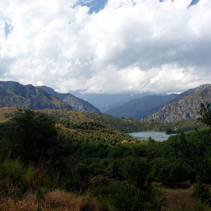
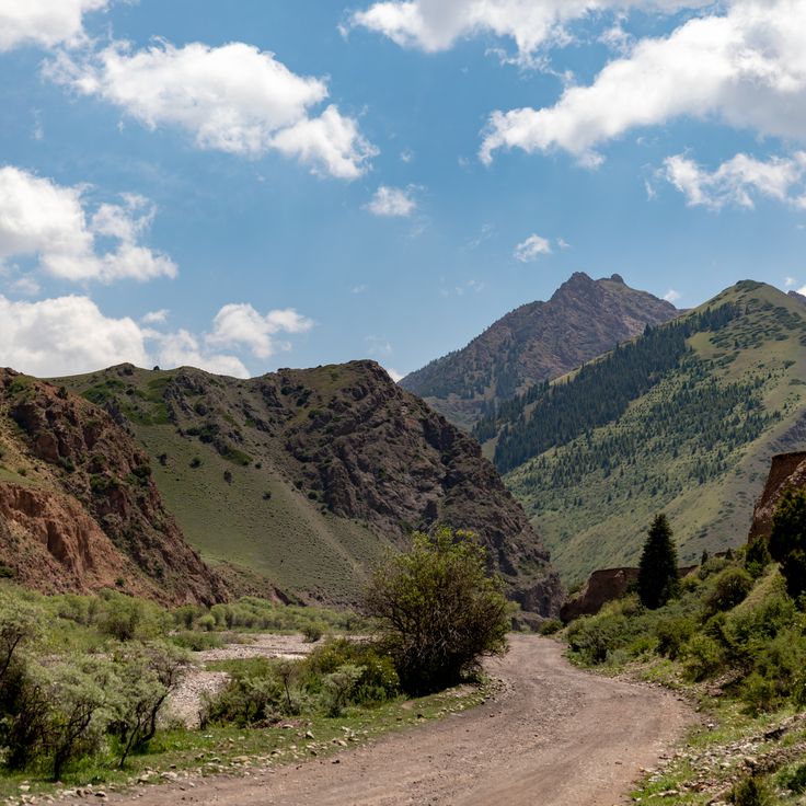
Kyrgyzstan offers photographers mountains, lakes and historic structures. The landscape ranges from the peaks of the Terskey Alatau Mountains to the shores of Lake Issyk-Kul, one of the largest alpine lakes in the world. In Ala Archa National Park, hiking trails lead through narrow valleys to glaciers such as Ak-Sai. Son-Kul Lake sits at over 10,000 feet (3,000 meters) and is used by herders in summer. The Altyn-Arashan Valley draws visitors with hot springs, while Skazka Canyon stands out for its colored rock formations.
Cultural sites include Burana Tower, an 11th-century minaret that marks a former city. Tash Rabat Caravanserai served as lodging for Silk Road travelers. In Osh, Sulaiman-Too Sacred Mountain is considered holy, with caves and mosques. The Dungan Mosque in Karakol displays Chinese wooden architecture. Petroglyphs at Cholpon-Ata and Saimaluu Tash document early human settlements. Arslanbob Walnut Forest spreads across hills and valleys. These places combine natural beauty with the history of the region.
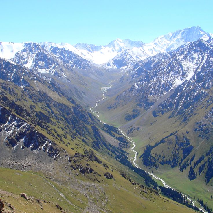
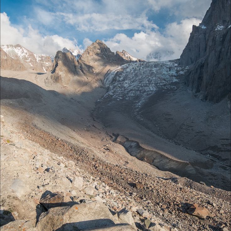
This park sits in the Tian Shan mountains and shows glaciers resting between peaks, along with waterfalls tumbling over rock ledges. Alpine vegetation covers the slopes at different elevations. Hiking trails wind through valleys with fast-moving streams. The landscape shifts from forested lower sections to bare high-altitude zones, where snowfields remain visible even in summer.
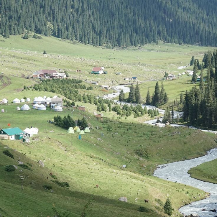
This alpine lake sits at 10,000 feet (3,016 meters) among open mountain meadows where nomads set up their yurts and graze livestock during the summer months. The clear waters of Son-Kul reflect the surrounding peaks. Visitors experience traditional ways of life in a landscape that blooms with wildflowers from early summer through autumn, offering photographers quiet scenes of sky, water and grassland.
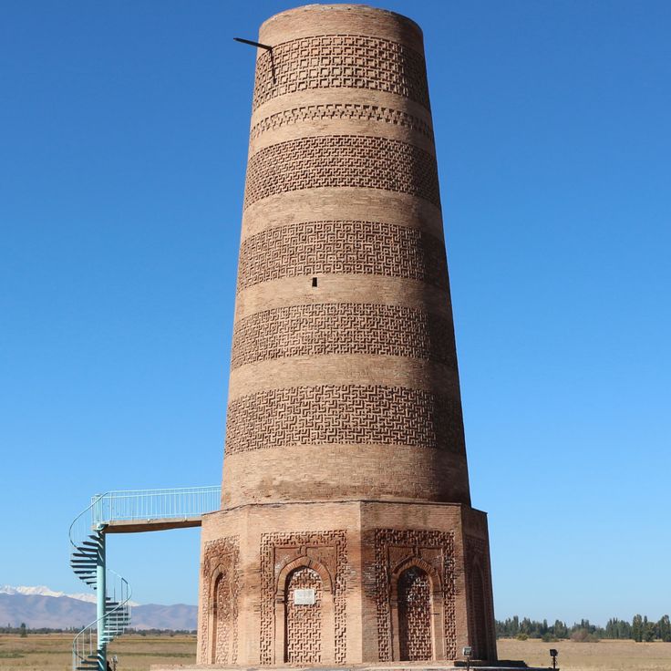
This tower from the 11th century was once part of a medieval city and now serves as a museum and observation point. The brick structure stands in an open landscape, surrounded by stone figures brought here from the region. Visitors can climb the narrow staircase and look out over the plains of the Chuy Valley, where a major Silk Road settlement once stood. The grounds show foundations of former buildings and offer insight into the history of the early Karakhanid period. This tower is one of the few remaining witnesses of that era in Central Asia.
This caravanserai from the 15th century sits in a high valley at roughly 10,500 feet (3,200 meters) and served as a shelter for merchants on the Silk Road. Tash Rabat is built from dark stone, with thick walls and a maze of chambers that once housed travelers and their pack animals. The rounded domes and low passages create a sense of age and isolation. All around, bare pastures and distant mountains stretch out, and the harsh light at altitude lifts the structure against the wide sky. Inside, a cool stillness fills the rooms, and the window openings let in narrow beams. The building feels like a solid anchor in the landscape, a reminder of how people once moved through this remote corner.
This sacred mountain rises above Osh and holds caves where people have prayed for centuries. The rocks show carvings from different eras, some Islamic, others older. Two small mosques stand among the paths. From the top you see the city and the fields around it. Pilgrims come here to pray and to find quiet among the stones.
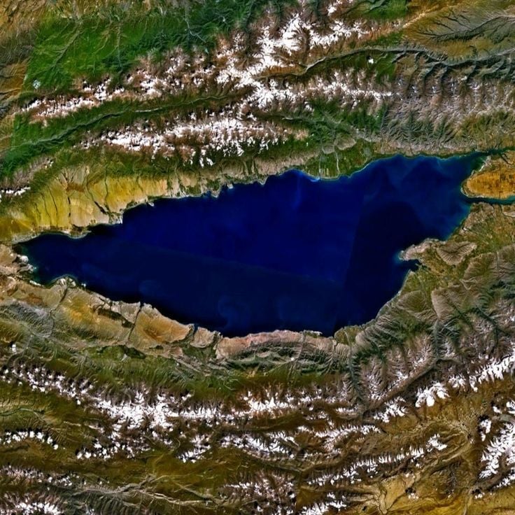
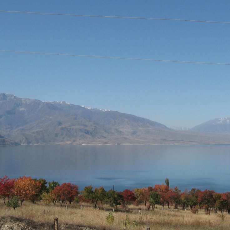
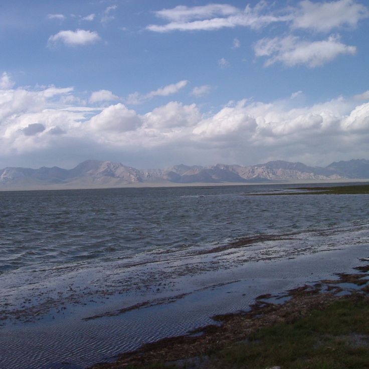
This saline lake sits at 5250 feet (1600 meters) elevation in the Tian Shan mountains and stretches 112 miles (180 kilometers) from east to west. The water remains unfrozen year-round, surrounded by snow-covered peaks and beaches. Hikers and photographers find changing light over the water surface, while small settlements along the shore define life around the lake. The quiet bays and clear water make this lake a draw for visitors.
This garden was founded in 1938 and now holds over 2000 plant species from different climate zones. Photographers find quiet paths between flower beds, greenhouses and tree groupings. The grounds show both native species from the mountains of Kyrgyzstan and plants from other continents. Visitors discover shaded alleys, small ponds and open lawns that change with the seasons.
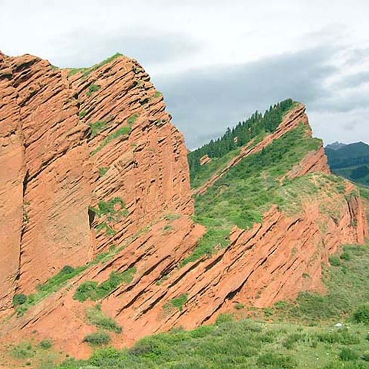
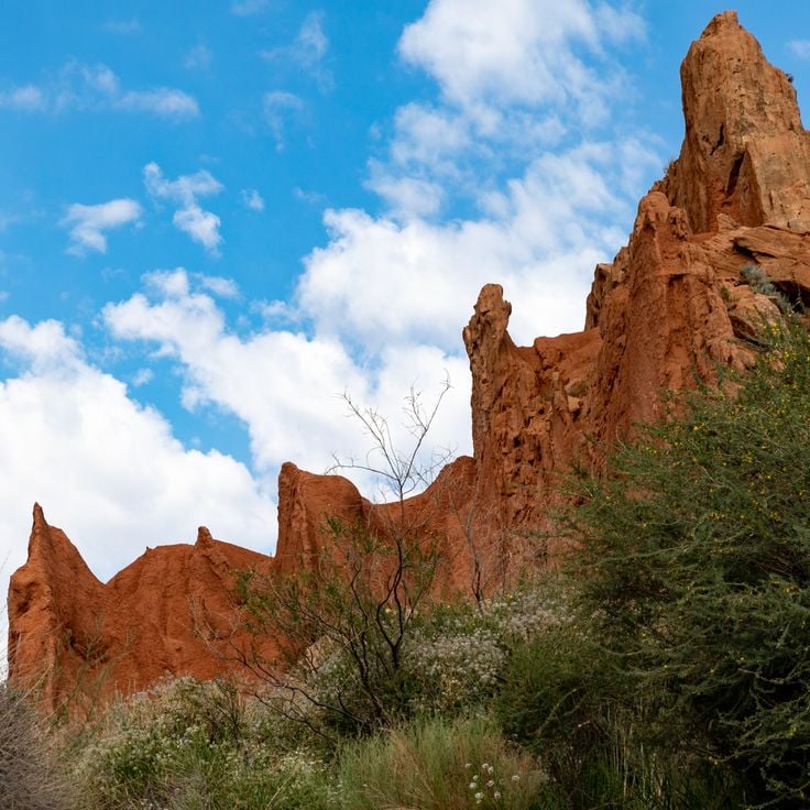
These seven red sandstone cliffs rise about 400 meters (1,300 feet) above the valley in the Tian Shan mountains, offering photographers a striking geological formation. The reddish color of the sandstone contrasts with the surrounding mountain landscape, creating a distinctive subject for photography in Kyrgyzstan.
This forest spreads across mountain slopes in the southwest and has been valued for its walnut trees for centuries. The trees grow naturally on the hillsides, with some reaching ages of several hundred years. Trails wind between the trunks toward waterfalls and clearings where photographers find compositions of woodland, rock and flowing water. In autumn the leaves turn yellow and brown, while spring brings fresh green foliage and wildflowers. Local people gather walnuts and apples during harvest season. The paths vary in condition, with some sections requiring sturdy footwear.
This red and orange sandstone formation rises along the southern shore of Lake Issyk-Kul. Wind and rain carved towers, pillars and walls over millions of years, creating shapes that resemble fortresses or sculptures. The rocks change color depending on the time of day and the angle of the light. Walking paths wind through the formations, allowing photographers to capture different perspectives. The name means "fairy tale" in Russian, a reference to the otherworldly shapes of the canyon.
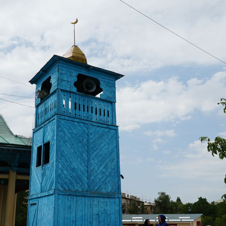
This mosque stands in Karakol and represents the building traditions of the Dungan people, a Muslim community originating from China. Craftsmen constructed the structure entirely from wood in 1910 without using metal nails. The architecture combines Chinese timber techniques with Islamic elements. Painted eaves, carved columns and bright colors recall a Chinese temple, while calligraphy and patterns reflect the religious purpose. This location documents the history of the Dungan community in Central Asia and offers photographers a chance to capture distinctive wooden craftsmanship.
This valley sits at 8200 feet (2500 meters) elevation in the mountains of Issyk-Kul Region and attracts photographers with its mineral springs and surrounding mountain scenery. The peaks rise to 13,000 feet (4000 meters), and hiking trails wind through meadows and forests to the hot springs that bubble from the ground.
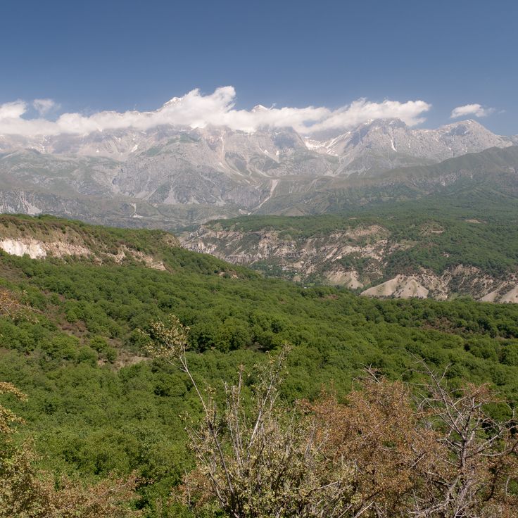
These mountains extend for several hundred kilometers along the southern shore of Lake Issyk-Kul and reach heights above 16,000 feet (5,000 meters). The highest peaks carry glaciers that flow between steep rock walls. Valleys lead into remote areas where herders bring their livestock during summer. From the slopes, wide views open toward the lake and the surrounding high plains. The landscape shifts between rocky ridges, alpine meadows and narrow gorges.
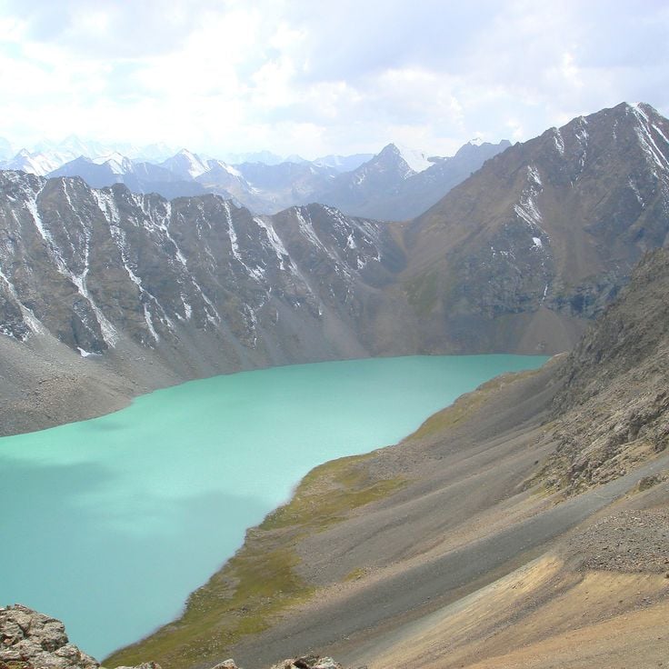
This glacial lake sits at 11500 feet (3500 meters) between steep mountain slopes in the Tian Shan range. The water shows an intense blue color that comes from glacial sediment and high altitude. The climb to the lake passes through valleys with wildflowers and rocky terrain. Hikers reach the lake after several hours of mountain trekking through sparsely populated high country.
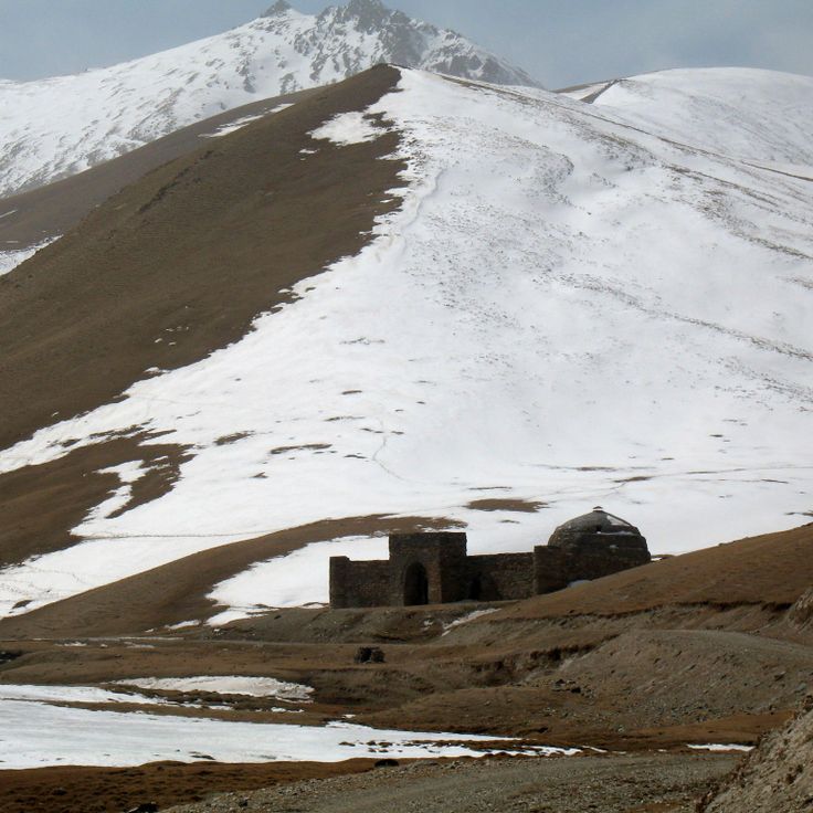
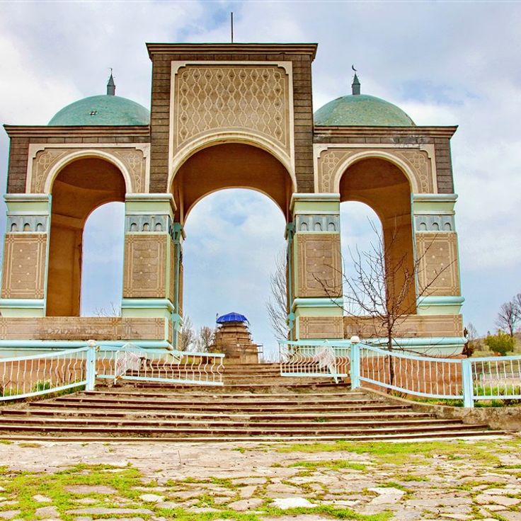
This 11th century Islamic tomb displays geometric decorations and Arabic calligraphy on its interior walls and dome. The structure documents early Islamic architecture in this region and offers photographers the chance to capture details of historical stonework. The location in a quiet area of Osh Province allows focused shots without large crowds.
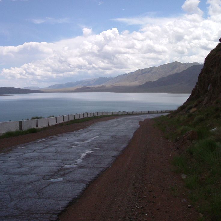
This reservoir supplies water to the region and sits below the surrounding mountains. Orto-Tokoy Reservoir offers visitors the chance to watch sunsets from the shore. The water reflects the peaks when the weather is calm. Fishermen use the reservoir, and hikers explore the hills nearby. The road along the shore passes through open terrain with little vegetation. Photographers come here for the light in the late afternoon and the mountain shapes on the horizon.
This thermal bath sits at the base of the mountains and offers hot mineral springs that bubble up from the ground. A park with pine trees surrounds the facility. The red sandstone cliffs nearby glow in sunlight. Walking trails lead through the valley and up to the cliffs. Visitors come here to bathe in the warm springs and photograph the rock formations that stand out against the sky.
This glacier sits at 13,000 feet (4,000 meters) in the mountains and extends for about 1.2 miles (2 kilometers). Hikers reach the glacier area through marked trails that lead through the high alpine landscape. The surroundings offer views of ice fields and rock formations. The area is part of Kyrgyzstan's alpine zone and draws photographers looking to capture mountain landscapes and glaciers.
The Kurmanjan Datka Museum sits on a hill in Osh and displays objects from the life of the ruler who governed southern Kyrgyzstan in the 19th century. The exhibition rooms contain clothing, jewelry, weapons and furniture from that period. Large windows offer views across the city and the surrounding mountains. The architecture of this building combines traditional elements with later additions. Photographers find subjects here that connect historical heritage with landscape, including panoramas from the entrance and the interior rooms with their exhibits.
This biosphere reserve is shaped by forests and seven mountain lakes set in a valley with wooded slopes. The reserve lies in the western foothills of the Tian Shan range and is home to many plant species, including walnut and apple trees. Narrow paths wind through dense vegetation, and from higher points the view opens over the lakes and surrounding peaks. The forests alternate with open grassy areas, the trails are often quiet, and the water of the lakes mirrors the greenery around them. The area is of interest to photographers looking to capture the natural structures and plant diversity within a mountainous frame.
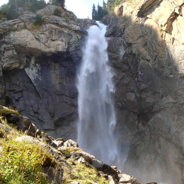
This waterfall drops down several stone steps, fed by meltwater from the surrounding snow-covered mountains. The rushing water tumbles between rocks and vegetation while the mountain air stays cool and refreshing. A path leads visitors closer to the cascades, where the roar of falling water drowns out other sounds and droplets hang in the air.
This historical cemetery preserves the memory of people who became victims of political persecution in the 1930s. The memorial stones carry names and stories of the deceased and stand in gentle hills near Bishkek. The site fits into the steppe landscape and offers a place of quiet. Visitors find inscriptions in several languages and learn about the fates of families who suffered under Soviet rule. The cemetery connects history with landscape and invites reflection.
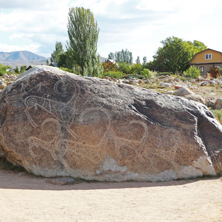
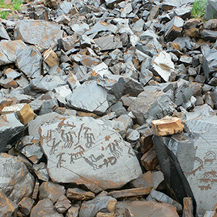
These Bronze Age rock carvings sit at the base of the Tian Shan mountains and show hunting scenes, animal figures and ritual symbols on granite stones. The petroglyphs of Cholpon-Ata document the life and spiritual practices of early communities and offer photographers a view into the ancient culture of the region within the mountain setting.
This mountain lake sits at 1873 meters elevation in the Tian Shan range and is known for its clear water, which reaches depths of 234 meters. Walnut forests and fruit trees grow along the shores of Sary-Chelek, offering photographers landscapes that change with the seasons. The lake fits into the surrounding mountains and shows reflections on the calm surface.
This artificial lake in western Kyrgyzstan has provided electricity and irrigation to surrounding areas since 1975. Toktogul Reservoir sits between mountains and offers calm water surfaces that change with shifting light and seasons. The shores are sometimes bare, sometimes lined with grasses, and the water reaches far into the valleys. Photographers appreciate the wide landscape and the clean lines between water, sky and mountains. The reservoir forms part of Kyrgyzstan's natural photography locations, combining human engineering with mountain geography.
This site shows rock carvings from the Bronze Age, located at an altitude of 3000 meters (9800 feet). The stones carry representations of people, animals and hunting scenes. The carvings were created over several centuries. The area sits on a high plateau, surrounded by grassy slopes. Photographers find here a combination of archaeological evidence and mountain landscape.
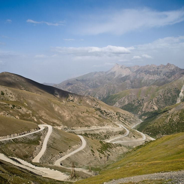
This mountain pass connects the northern Alay Valley with the southern Fergana Valley through a winding mountain road at 3615 meters (11,860 feet). The landscape shows bare mountain slopes, deep gorges and wide views over the surrounding peaks. For photographers, Taldyk Pass offers dramatic perspectives with its hairpin turns that twist through the rocks, and the contrasts between stone, sky and occasional cloud formations. Nomadic herders sometimes pass through the region with their flocks.
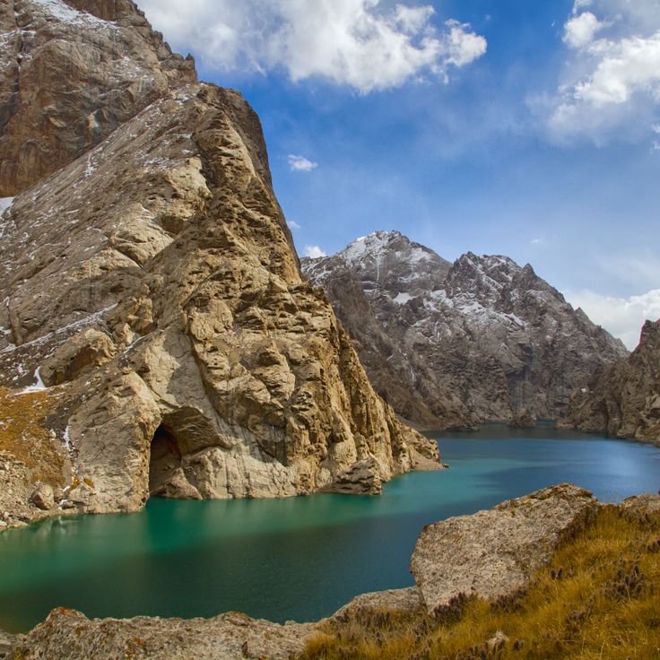
Kel-Suu Lake sits at 11,500 feet (3,500 meters) above sea level, surrounded by limestone walls that rise straight from the water. A narrow track winds through the gorge to reach the shore. The silence here is almost complete, broken only by wind and the occasional bird. Light shifts across the rock faces throughout the day, changing their color from gray to orange. Few travelers make it this far, and the journey requires time and patience. The water is cold and reflects the cliffs above. The air is thin, and you feel the altitude in your breath.
This mountain lake sits at 11580 feet (3530 meters) between the At-Bashy and Torugart ranges. The water freezes from October through April. The area is thinly populated and crossed mostly by herders and travelers. The landscape consists of open high plateaus with sparse grass growth during summer. The air is thin and clear, and silence is broken only by wind. This lake is one of the highest bodies of water in the country and offers photographers the chance to capture the stark mountain landscapes of Kyrgyzstan.
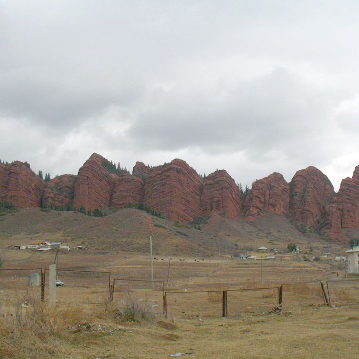
This village sits among red rock formations in the Naryn Region. The houses are made of clay and blend into the landscape. Residents craft felt carpets and other handmade items that visitors can observe during a stay. The steep slopes and valleys surrounding Kyzyl-Oi offer photographers views of rock layers formed over millions of years, while the village life itself provides insight into rural traditions of Kyrgyzstan.
These mountains connect the central Tian Shan system to the higher peaks of the Pamir, forming a natural barrier south of Osh. The Pamir-Alay range stretches across wide valleys and high passes, where glaciers spread between rocky slopes. Hikers and photographers find remote lakes here, their cold waters fed by melting snow. In summer, wildflowers bloom on alpine meadows, while the higher elevations remain covered in ice throughout the year. Nomadic herders lead their flocks through the valleys, and small villages sit scattered at the base of the slopes. The landscape shifts from gentle grasslands to steep ridges that cut sharply against the sky.
This park sits in the Tian Shan mountains and shows glaciers resting between peaks, along with waterfalls tumbling over rock ledges. Alpine vegetation covers the slopes at different elevations. Hiking trails wind through valleys with fast-moving streams. The landscape shifts from forested lower sections to bare high-altitude zones, where snowfields remain visible even in summer.
This alpine lake sits at 10,000 feet (3,016 meters) among open mountain meadows where nomads set up their yurts and graze livestock during the summer months. The clear waters of Son-Kul reflect the surrounding peaks. Visitors experience traditional ways of life in a landscape that blooms with wildflowers from early summer through autumn, offering photographers quiet scenes of sky, water and grassland.
This tower from the 11th century was once part of a medieval city and now serves as a museum and observation point. The brick structure stands in an open landscape, surrounded by stone figures brought here from the region. Visitors can climb the narrow staircase and look out over the plains of the Chuy Valley, where a major Silk Road settlement once stood. The grounds show foundations of former buildings and offer insight into the history of the early Karakhanid period. This tower is one of the few remaining witnesses of that era in Central Asia.
This caravanserai from the 15th century sits in a high valley at roughly 10,500 feet (3,200 meters) and served as a shelter for merchants on the Silk Road. Tash Rabat is built from dark stone, with thick walls and a maze of chambers that once housed travelers and their pack animals. The rounded domes and low passages create a sense of age and isolation. All around, bare pastures and distant mountains stretch out, and the harsh light at altitude lifts the structure against the wide sky. Inside, a cool stillness fills the rooms, and the window openings let in narrow beams. The building feels like a solid anchor in the landscape, a reminder of how people once moved through this remote corner.
This sacred mountain rises above Osh and holds caves where people have prayed for centuries. The rocks show carvings from different eras, some Islamic, others older. Two small mosques stand among the paths. From the top you see the city and the fields around it. Pilgrims come here to pray and to find quiet among the stones.
This saline lake sits at 5250 feet (1600 meters) elevation in the Tian Shan mountains and stretches 112 miles (180 kilometers) from east to west. The water remains unfrozen year-round, surrounded by snow-covered peaks and beaches. Hikers and photographers find changing light over the water surface, while small settlements along the shore define life around the lake. The quiet bays and clear water make this lake a draw for visitors.
This garden was founded in 1938 and now holds over 2000 plant species from different climate zones. Photographers find quiet paths between flower beds, greenhouses and tree groupings. The grounds show both native species from the mountains of Kyrgyzstan and plants from other continents. Visitors discover shaded alleys, small ponds and open lawns that change with the seasons.
These seven red sandstone cliffs rise about 400 meters (1,300 feet) above the valley in the Tian Shan mountains, offering photographers a striking geological formation. The reddish color of the sandstone contrasts with the surrounding mountain landscape, creating a distinctive subject for photography in Kyrgyzstan.
This forest spreads across mountain slopes in the southwest and has been valued for its walnut trees for centuries. The trees grow naturally on the hillsides, with some reaching ages of several hundred years. Trails wind between the trunks toward waterfalls and clearings where photographers find compositions of woodland, rock and flowing water. In autumn the leaves turn yellow and brown, while spring brings fresh green foliage and wildflowers. Local people gather walnuts and apples during harvest season. The paths vary in condition, with some sections requiring sturdy footwear.
This red and orange sandstone formation rises along the southern shore of Lake Issyk-Kul. Wind and rain carved towers, pillars and walls over millions of years, creating shapes that resemble fortresses or sculptures. The rocks change color depending on the time of day and the angle of the light. Walking paths wind through the formations, allowing photographers to capture different perspectives. The name means "fairy tale" in Russian, a reference to the otherworldly shapes of the canyon.
This mosque stands in Karakol and represents the building traditions of the Dungan people, a Muslim community originating from China. Craftsmen constructed the structure entirely from wood in 1910 without using metal nails. The architecture combines Chinese timber techniques with Islamic elements. Painted eaves, carved columns and bright colors recall a Chinese temple, while calligraphy and patterns reflect the religious purpose. This location documents the history of the Dungan community in Central Asia and offers photographers a chance to capture distinctive wooden craftsmanship.
This valley sits at 8200 feet (2500 meters) elevation in the mountains of Issyk-Kul Region and attracts photographers with its mineral springs and surrounding mountain scenery. The peaks rise to 13,000 feet (4000 meters), and hiking trails wind through meadows and forests to the hot springs that bubble from the ground.
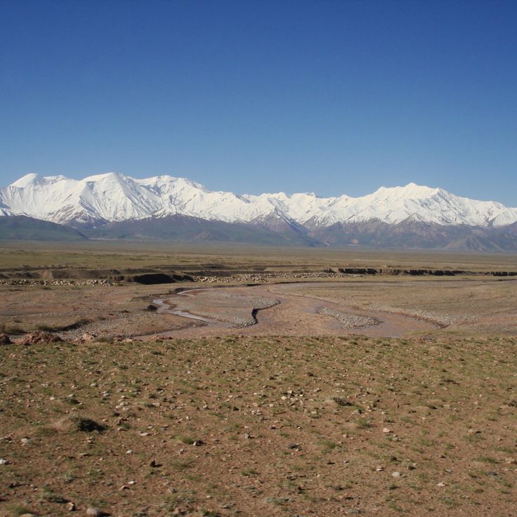
These mountains extend for several hundred kilometers along the southern shore of Lake Issyk-Kul and reach heights above 16,000 feet (5,000 meters). The highest peaks carry glaciers that flow between steep rock walls. Valleys lead into remote areas where herders bring their livestock during summer. From the slopes, wide views open toward the lake and the surrounding high plains. The landscape shifts between rocky ridges, alpine meadows and narrow gorges.
This glacial lake sits at 11500 feet (3500 meters) between steep mountain slopes in the Tian Shan range. The water shows an intense blue color that comes from glacial sediment and high altitude. The climb to the lake passes through valleys with wildflowers and rocky terrain. Hikers reach the lake after several hours of mountain trekking through sparsely populated high country.
This 11th century Islamic tomb displays geometric decorations and Arabic calligraphy on its interior walls and dome. The structure documents early Islamic architecture in this region and offers photographers the chance to capture details of historical stonework. The location in a quiet area of Osh Province allows focused shots without large crowds.
This reservoir supplies water to the region and sits below the surrounding mountains. Orto-Tokoy Reservoir offers visitors the chance to watch sunsets from the shore. The water reflects the peaks when the weather is calm. Fishermen use the reservoir, and hikers explore the hills nearby. The road along the shore passes through open terrain with little vegetation. Photographers come here for the light in the late afternoon and the mountain shapes on the horizon.
This thermal bath sits at the base of the mountains and offers hot mineral springs that bubble up from the ground. A park with pine trees surrounds the facility. The red sandstone cliffs nearby glow in sunlight. Walking trails lead through the valley and up to the cliffs. Visitors come here to bathe in the warm springs and photograph the rock formations that stand out against the sky.
This glacier sits at 13,000 feet (4,000 meters) in the mountains and extends for about 1.2 miles (2 kilometers). Hikers reach the glacier area through marked trails that lead through the high alpine landscape. The surroundings offer views of ice fields and rock formations. The area is part of Kyrgyzstan's alpine zone and draws photographers looking to capture mountain landscapes and glaciers.
The Kurmanjan Datka Museum sits on a hill in Osh and displays objects from the life of the ruler who governed southern Kyrgyzstan in the 19th century. The exhibition rooms contain clothing, jewelry, weapons and furniture from that period. Large windows offer views across the city and the surrounding mountains. The architecture of this building combines traditional elements with later additions. Photographers find subjects here that connect historical heritage with landscape, including panoramas from the entrance and the interior rooms with their exhibits.
This biosphere reserve is shaped by forests and seven mountain lakes set in a valley with wooded slopes. The reserve lies in the western foothills of the Tian Shan range and is home to many plant species, including walnut and apple trees. Narrow paths wind through dense vegetation, and from higher points the view opens over the lakes and surrounding peaks. The forests alternate with open grassy areas, the trails are often quiet, and the water of the lakes mirrors the greenery around them. The area is of interest to photographers looking to capture the natural structures and plant diversity within a mountainous frame.
This waterfall drops down several stone steps, fed by meltwater from the surrounding snow-covered mountains. The rushing water tumbles between rocks and vegetation while the mountain air stays cool and refreshing. A path leads visitors closer to the cascades, where the roar of falling water drowns out other sounds and droplets hang in the air.
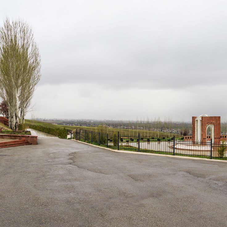
This historical cemetery preserves the memory of people who became victims of political persecution in the 1930s. The memorial stones carry names and stories of the deceased and stand in gentle hills near Bishkek. The site fits into the steppe landscape and offers a place of quiet. Visitors find inscriptions in several languages and learn about the fates of families who suffered under Soviet rule. The cemetery connects history with landscape and invites reflection.
These Bronze Age rock carvings sit at the base of the Tian Shan mountains and show hunting scenes, animal figures and ritual symbols on granite stones. The petroglyphs of Cholpon-Ata document the life and spiritual practices of early communities and offer photographers a view into the ancient culture of the region within the mountain setting.
This mountain lake sits at 1873 meters elevation in the Tian Shan range and is known for its clear water, which reaches depths of 234 meters. Walnut forests and fruit trees grow along the shores of Sary-Chelek, offering photographers landscapes that change with the seasons. The lake fits into the surrounding mountains and shows reflections on the calm surface.
This artificial lake in western Kyrgyzstan has provided electricity and irrigation to surrounding areas since 1975. Toktogul Reservoir sits between mountains and offers calm water surfaces that change with shifting light and seasons. The shores are sometimes bare, sometimes lined with grasses, and the water reaches far into the valleys. Photographers appreciate the wide landscape and the clean lines between water, sky and mountains. The reservoir forms part of Kyrgyzstan's natural photography locations, combining human engineering with mountain geography.
This site shows rock carvings from the Bronze Age, located at an altitude of 3000 meters (9800 feet). The stones carry representations of people, animals and hunting scenes. The carvings were created over several centuries. The area sits on a high plateau, surrounded by grassy slopes. Photographers find here a combination of archaeological evidence and mountain landscape.
This mountain pass connects the northern Alay Valley with the southern Fergana Valley through a winding mountain road at 3615 meters (11,860 feet). The landscape shows bare mountain slopes, deep gorges and wide views over the surrounding peaks. For photographers, Taldyk Pass offers dramatic perspectives with its hairpin turns that twist through the rocks, and the contrasts between stone, sky and occasional cloud formations. Nomadic herders sometimes pass through the region with their flocks.
Kel-Suu Lake sits at 11,500 feet (3,500 meters) above sea level, surrounded by limestone walls that rise straight from the water. A narrow track winds through the gorge to reach the shore. The silence here is almost complete, broken only by wind and the occasional bird. Light shifts across the rock faces throughout the day, changing their color from gray to orange. Few travelers make it this far, and the journey requires time and patience. The water is cold and reflects the cliffs above. The air is thin, and you feel the altitude in your breath.
This mountain lake sits at 11580 feet (3530 meters) between the At-Bashy and Torugart ranges. The water freezes from October through April. The area is thinly populated and crossed mostly by herders and travelers. The landscape consists of open high plateaus with sparse grass growth during summer. The air is thin and clear, and silence is broken only by wind. This lake is one of the highest bodies of water in the country and offers photographers the chance to capture the stark mountain landscapes of Kyrgyzstan.
This village sits among red rock formations in the Naryn Region. The houses are made of clay and blend into the landscape. Residents craft felt carpets and other handmade items that visitors can observe during a stay. The steep slopes and valleys surrounding Kyzyl-Oi offer photographers views of rock layers formed over millions of years, while the village life itself provides insight into rural traditions of Kyrgyzstan.
These mountains connect the central Tian Shan system to the higher peaks of the Pamir, forming a natural barrier south of Osh. The Pamir-Alay range stretches across wide valleys and high passes, where glaciers spread between rocky slopes. Hikers and photographers find remote lakes here, their cold waters fed by melting snow. In summer, wildflowers bloom on alpine meadows, while the higher elevations remain covered in ice throughout the year. Nomadic herders lead their flocks through the valleys, and small villages sit scattered at the base of the slopes. The landscape shifts from gentle grasslands to steep ridges that cut sharply against the sky.
This park sits in the Tian Shan mountains and shows glaciers resting between peaks, along with waterfalls tumbling over rock ledges. Alpine vegetation covers the slopes at different elevations. Hiking trails wind through valleys with fast-moving streams. The landscape shifts from forested lower sections to bare high-altitude zones, where snowfields remain visible even in summer.
This alpine lake sits at 10,000 feet (3,016 meters) among open mountain meadows where nomads set up their yurts and graze livestock during the summer months. The clear waters of Son-Kul reflect the surrounding peaks. Visitors experience traditional ways of life in a landscape that blooms with wildflowers from early summer through autumn, offering photographers quiet scenes of sky, water and grassland.
This tower from the 11th century was once part of a medieval city and now serves as a museum and observation point. The brick structure stands in an open landscape, surrounded by stone figures brought here from the region. Visitors can climb the narrow staircase and look out over the plains of the Chuy Valley, where a major Silk Road settlement once stood. The grounds show foundations of former buildings and offer insight into the history of the early Karakhanid period. This tower is one of the few remaining witnesses of that era in Central Asia.
This caravanserai from the 15th century sits in a high valley at roughly 10,500 feet (3,200 meters) and served as a shelter for merchants on the Silk Road. Tash Rabat is built from dark stone, with thick walls and a maze of chambers that once housed travelers and their pack animals. The rounded domes and low passages create a sense of age and isolation. All around, bare pastures and distant mountains stretch out, and the harsh light at altitude lifts the structure against the wide sky. Inside, a cool stillness fills the rooms, and the window openings let in narrow beams. The building feels like a solid anchor in the landscape, a reminder of how people once moved through this remote corner.
This sacred mountain rises above Osh and holds caves where people have prayed for centuries. The rocks show carvings from different eras, some Islamic, others older. Two small mosques stand among the paths. From the top you see the city and the fields around it. Pilgrims come here to pray and to find quiet among the stones.
This saline lake sits at 5250 feet (1600 meters) elevation in the Tian Shan mountains and stretches 112 miles (180 kilometers) from east to west. The water remains unfrozen year-round, surrounded by snow-covered peaks and beaches. Hikers and photographers find changing light over the water surface, while small settlements along the shore define life around the lake. The quiet bays and clear water make this lake a draw for visitors.
This garden was founded in 1938 and now holds over 2000 plant species from different climate zones. Photographers find quiet paths between flower beds, greenhouses and tree groupings. The grounds show both native species from the mountains of Kyrgyzstan and plants from other continents. Visitors discover shaded alleys, small ponds and open lawns that change with the seasons.
These seven red sandstone cliffs rise about 400 meters (1,300 feet) above the valley in the Tian Shan mountains, offering photographers a striking geological formation. The reddish color of the sandstone contrasts with the surrounding mountain landscape, creating a distinctive subject for photography in Kyrgyzstan.
This forest spreads across mountain slopes in the southwest and has been valued for its walnut trees for centuries. The trees grow naturally on the hillsides, with some reaching ages of several hundred years. Trails wind between the trunks toward waterfalls and clearings where photographers find compositions of woodland, rock and flowing water. In autumn the leaves turn yellow and brown, while spring brings fresh green foliage and wildflowers. Local people gather walnuts and apples during harvest season. The paths vary in condition, with some sections requiring sturdy footwear.
This red and orange sandstone formation rises along the southern shore of Lake Issyk-Kul. Wind and rain carved towers, pillars and walls over millions of years, creating shapes that resemble fortresses or sculptures. The rocks change color depending on the time of day and the angle of the light. Walking paths wind through the formations, allowing photographers to capture different perspectives. The name means "fairy tale" in Russian, a reference to the otherworldly shapes of the canyon.
This mosque stands in Karakol and represents the building traditions of the Dungan people, a Muslim community originating from China. Craftsmen constructed the structure entirely from wood in 1910 without using metal nails. The architecture combines Chinese timber techniques with Islamic elements. Painted eaves, carved columns and bright colors recall a Chinese temple, while calligraphy and patterns reflect the religious purpose. This location documents the history of the Dungan community in Central Asia and offers photographers a chance to capture distinctive wooden craftsmanship.
This valley sits at 8200 feet (2500 meters) elevation in the mountains of Issyk-Kul Region and attracts photographers with its mineral springs and surrounding mountain scenery. The peaks rise to 13,000 feet (4000 meters), and hiking trails wind through meadows and forests to the hot springs that bubble from the ground.
These mountains extend for several hundred kilometers along the southern shore of Lake Issyk-Kul and reach heights above 16,000 feet (5,000 meters). The highest peaks carry glaciers that flow between steep rock walls. Valleys lead into remote areas where herders bring their livestock during summer. From the slopes, wide views open toward the lake and the surrounding high plains. The landscape shifts between rocky ridges, alpine meadows and narrow gorges.
This glacial lake sits at 11500 feet (3500 meters) between steep mountain slopes in the Tian Shan range. The water shows an intense blue color that comes from glacial sediment and high altitude. The climb to the lake passes through valleys with wildflowers and rocky terrain. Hikers reach the lake after several hours of mountain trekking through sparsely populated high country.
This 11th century Islamic tomb displays geometric decorations and Arabic calligraphy on its interior walls and dome. The structure documents early Islamic architecture in this region and offers photographers the chance to capture details of historical stonework. The location in a quiet area of Osh Province allows focused shots without large crowds.
This reservoir supplies water to the region and sits below the surrounding mountains. Orto-Tokoy Reservoir offers visitors the chance to watch sunsets from the shore. The water reflects the peaks when the weather is calm. Fishermen use the reservoir, and hikers explore the hills nearby. The road along the shore passes through open terrain with little vegetation. Photographers come here for the light in the late afternoon and the mountain shapes on the horizon.
This thermal bath sits at the base of the mountains and offers hot mineral springs that bubble up from the ground. A park with pine trees surrounds the facility. The red sandstone cliffs nearby glow in sunlight. Walking trails lead through the valley and up to the cliffs. Visitors come here to bathe in the warm springs and photograph the rock formations that stand out against the sky.
This glacier sits at 13,000 feet (4,000 meters) in the mountains and extends for about 1.2 miles (2 kilometers). Hikers reach the glacier area through marked trails that lead through the high alpine landscape. The surroundings offer views of ice fields and rock formations. The area is part of Kyrgyzstan's alpine zone and draws photographers looking to capture mountain landscapes and glaciers.
The Kurmanjan Datka Museum sits on a hill in Osh and displays objects from the life of the ruler who governed southern Kyrgyzstan in the 19th century. The exhibition rooms contain clothing, jewelry, weapons and furniture from that period. Large windows offer views across the city and the surrounding mountains. The architecture of this building combines traditional elements with later additions. Photographers find subjects here that connect historical heritage with landscape, including panoramas from the entrance and the interior rooms with their exhibits.
This biosphere reserve is shaped by forests and seven mountain lakes set in a valley with wooded slopes. The reserve lies in the western foothills of the Tian Shan range and is home to many plant species, including walnut and apple trees. Narrow paths wind through dense vegetation, and from higher points the view opens over the lakes and surrounding peaks. The forests alternate with open grassy areas, the trails are often quiet, and the water of the lakes mirrors the greenery around them. The area is of interest to photographers looking to capture the natural structures and plant diversity within a mountainous frame.
This waterfall drops down several stone steps, fed by meltwater from the surrounding snow-covered mountains. The rushing water tumbles between rocks and vegetation while the mountain air stays cool and refreshing. A path leads visitors closer to the cascades, where the roar of falling water drowns out other sounds and droplets hang in the air.
This historical cemetery preserves the memory of people who became victims of political persecution in the 1930s. The memorial stones carry names and stories of the deceased and stand in gentle hills near Bishkek. The site fits into the steppe landscape and offers a place of quiet. Visitors find inscriptions in several languages and learn about the fates of families who suffered under Soviet rule. The cemetery connects history with landscape and invites reflection.
These Bronze Age rock carvings sit at the base of the Tian Shan mountains and show hunting scenes, animal figures and ritual symbols on granite stones. The petroglyphs of Cholpon-Ata document the life and spiritual practices of early communities and offer photographers a view into the ancient culture of the region within the mountain setting.
This mountain lake sits at 1873 meters elevation in the Tian Shan range and is known for its clear water, which reaches depths of 234 meters. Walnut forests and fruit trees grow along the shores of Sary-Chelek, offering photographers landscapes that change with the seasons. The lake fits into the surrounding mountains and shows reflections on the calm surface.
This artificial lake in western Kyrgyzstan has provided electricity and irrigation to surrounding areas since 1975. Toktogul Reservoir sits between mountains and offers calm water surfaces that change with shifting light and seasons. The shores are sometimes bare, sometimes lined with grasses, and the water reaches far into the valleys. Photographers appreciate the wide landscape and the clean lines between water, sky and mountains. The reservoir forms part of Kyrgyzstan's natural photography locations, combining human engineering with mountain geography.
This site shows rock carvings from the Bronze Age, located at an altitude of 3000 meters (9800 feet). The stones carry representations of people, animals and hunting scenes. The carvings were created over several centuries. The area sits on a high plateau, surrounded by grassy slopes. Photographers find here a combination of archaeological evidence and mountain landscape.
This mountain pass connects the northern Alay Valley with the southern Fergana Valley through a winding mountain road at 3615 meters (11,860 feet). The landscape shows bare mountain slopes, deep gorges and wide views over the surrounding peaks. For photographers, Taldyk Pass offers dramatic perspectives with its hairpin turns that twist through the rocks, and the contrasts between stone, sky and occasional cloud formations. Nomadic herders sometimes pass through the region with their flocks.
Kel-Suu Lake sits at 11,500 feet (3,500 meters) above sea level, surrounded by limestone walls that rise straight from the water. A narrow track winds through the gorge to reach the shore. The silence here is almost complete, broken only by wind and the occasional bird. Light shifts across the rock faces throughout the day, changing their color from gray to orange. Few travelers make it this far, and the journey requires time and patience. The water is cold and reflects the cliffs above. The air is thin, and you feel the altitude in your breath.
This mountain lake sits at 11580 feet (3530 meters) between the At-Bashy and Torugart ranges. The water freezes from October through April. The area is thinly populated and crossed mostly by herders and travelers. The landscape consists of open high plateaus with sparse grass growth during summer. The air is thin and clear, and silence is broken only by wind. This lake is one of the highest bodies of water in the country and offers photographers the chance to capture the stark mountain landscapes of Kyrgyzstan.
This village sits among red rock formations in the Naryn Region. The houses are made of clay and blend into the landscape. Residents craft felt carpets and other handmade items that visitors can observe during a stay. The steep slopes and valleys surrounding Kyzyl-Oi offer photographers views of rock layers formed over millions of years, while the village life itself provides insight into rural traditions of Kyrgyzstan.
These mountains connect the central Tian Shan system to the higher peaks of the Pamir, forming a natural barrier south of Osh. The Pamir-Alay range stretches across wide valleys and high passes, where glaciers spread between rocky slopes. Hikers and photographers find remote lakes here, their cold waters fed by melting snow. In summer, wildflowers bloom on alpine meadows, while the higher elevations remain covered in ice throughout the year. Nomadic herders lead their flocks through the valleys, and small villages sit scattered at the base of the slopes. The landscape shifts from gentle grasslands to steep ridges that cut sharply against the sky.