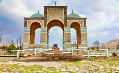
Shah Fazil Mausoleum, Religious burial complex in Ala-Buka District, Kyrgyzstan
The Shah Fazil Mausoleum is a square building standing 11 meters high, featuring a stepped drum base and a soaring dome. The structure contains multiple burial chambers and sits within a larger complex that includes a sacred mountain cave and additional tombs from different eras.
The mausoleum was built in the 11th century during the Karakhanid era as the final resting place of Mahmud ibn Nasir, a ruler of Fergana. Restoration work carried out in 2003 helped preserve its architectural features and decorative details.
The interior walls feature hand-carved plaster decorations in blue, yellow, and red patterns that showcase Central Asian artistic traditions. These designs cover the surfaces from floor to ceiling throughout the chamber.
The complex sits in a remote location and requires careful planning to visit, as there is minimal tourist infrastructure in the area. It is best visited during dry months when the site paths are fully accessible.
The site includes a sacred mountain cave of a hermit that has drawn spiritual seekers for centuries, making it more than just a tomb. This sacred geography creates an unusual connection between the built structure and the natural landscape.
The community of curious travelers
AroundUs brings together thousands of curated places, local tips, and hidden gems, enriched daily by 60,000 contributors worldwide.