Chest opened
+${chestReward.xp} XP
Explorer
NOUVEAU ×${chestReward.collectible.quantity}
tapez pour fermer
Chest locked

Open chests in the app

Around Us is built for your phone — chests unlock when you walk, explore and capture nearby places.

Enable Location

We need your location to show you interesting places around you

Discover nearby places

Find interesting locations and hidden gems around you

Precise directions

Get accurate directions and distances to places

Your location is never shared with other users. It's only used when you tap the location button.

Saray-Jük

Log in to your account

Start exploring — it's free

Trusted by 72,887 travelers worldwide

Continue with Google
Continue with Apple
or

We will send you a code to connect

By continuing, you accept our Terms and Conditions and our Privacy Policy

Check your inbox

We've sent a pincode in your inbox. Please enter the code below.

Saray-Jük
Discussion Reviews 1 Photos
26.9k Popularity

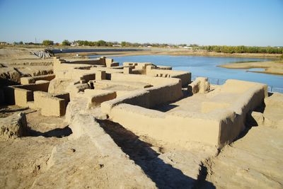
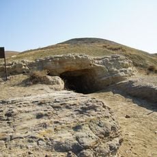
Saray-Jük, Medieval archaeological site on Ural River, Atyrau Region, Kazakhstan

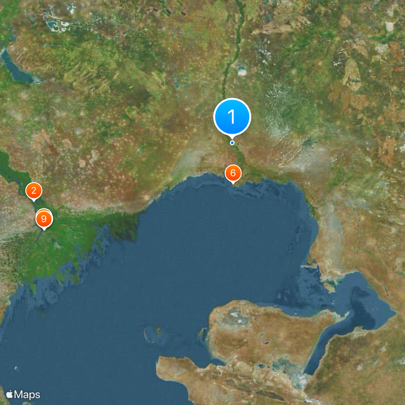
Saray-Jük lies about 50 kilometers north of Atyrau along the Ural River and contains the remains of an ancient settlement with stone and mud-brick structures. The site spreads across the riverbank with scattered ruins and earth mounds visible across the flat steppe landscape.

The site developed between the 13th and 16th centuries as a significant city under Golden Horde rule and served as a trading post connecting Europe and Asia. During this period it flourished through the exchange of goods and ideas among different peoples.

Excavated pottery with inscriptions, jewelry, and building materials show how merchants and craftspeople worked here as a major stop on trade routes. The objects found reveal the daily skills and commerce that connected distant lands through this settlement.

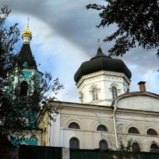
A memorial complex built in 1999 provides access to the site with displayed artifacts and information panels about the settlement. The location is easiest to visit during warmer months when the paths are dry and walkable.

The Ural River constantly erodes the site, gradually exposing new layers of the ancient settlement buried beneath the surface. This ongoing natural process means that fresh discoveries continue to emerge, making archaeology here an active process rather than a finished story.

The community of curious travelers

AroundUs brings together thousands of curated places, local tips, and hidden gems, enriched daily by 60,000 contributors worldwide.

Start exploring
Location
GPS coordinates
47.50000,51.73333
Latest update
December 20, 2025 14:33
Around this place
Volga Delta
Russian Federation

Volga Delta

306.3 km
Opera and Ballet Theatre of Astrakhan
Russian Federation

Opera and Ballet Theatre of Astrakhan

307.8 km
Astrakhan Oak
Russian Federation

Astrakhan Oak

306.5 km
Central Stadium
Russian Federation

Central Stadium

306.3 km
State Nature Reservat "Akzhaiyk"
Kazakhstan

State Nature Reservat "Akzhaiyk"

59.4 km
Astrakhan State Art Gallery
Russian Federation

Astrakhan State Art Gallery

307.7 km
Monastery of Saint John the Baptist in Astrakhan
Russian Federation

Monastery of Saint John the Baptist in Astrakhan

307.3 km
Astrakhan State Drama Theatre
Russian Federation

Astrakhan State Drama Theatre

308.3 km
Church of the Assumption of Mary
Russian Federation

Church of the Assumption of Mary

308 km
Assumption Nicholas Churkinsky Monastery
Russian Federation

Assumption Nicholas Churkinsky Monastery

264.8 km
Communication tower in Astrakhan
Russian Federation

Communication tower in Astrakhan

307.4 km
Kurmangazy monument in Astrakhan
Russian Federation

Kurmangazy monument in Astrakhan

308 km
Intercession Boldin monastery
Russian Federation

Intercession Boldin monastery

304.1 km
Kazakhstan

Manjali Mosque

45.7 km
Imanqara
Kazakhstan

Imanqara

205.4 km
Սուրբ Աստվածածնին եկեղեցուն ընծայելու տաճար
Russian Federation

Սուրբ Աստվածածնին եկեղեցուն ընծայելու տաճար

307.1 km
Мұнайшылар қалашығы
Kazakhstan

Мұнайшылар қалашығы

46.6 km
Хрестовий заказник
Russian Federation

Хрестовий заказник

307.3 km
Aqua Town
Kazakhstan

Aqua Town

43.3 km
Золотой Джин
Russian Federation

Золотой Джин

308 km
Bolshye Isady
Russian Federation

Bolshye Isady

307.8 km
Голден клаб
Russian Federation

Голден клаб

304.4 km
Yamgurchev
Russian Federation

Yamgurchev

307.8 km
Blue water T
Kazakhstan

Blue water T

176.6 km
Великомогойський
Russian Federation

Великомогойський

264.5 km
Діановський нерестовий масив
Russian Federation

Діановський нерестовий масив

263 km
Church of the Nativity of Christ, Astrakhan
Russian Federation

Church of the Nativity of Christ, Astrakhan

307.3 km
Maloye Ganyushkino
Kazakhstan

Maloye Ganyushkino

212.2 km
Show the full map
Reviews
Share your experience

No review yet

Discussions
Start a discussion...

No discussion yet

« Saray-Jük - Medieval archaeological site on Ural River, Atyrau Region, Kazakhstan » is provided by Around Us (aroundus.com). Images and texts are derived from Wikimedia project under a Creative Commons license. You are allowed to copy, distribute, and modify copies of this page, under the conditions set by the license, as long as this note is clearly visible.

Discover hidden gems everywhere you go!

From secret cafés to breathtaking viewpoints, skip the crowded tourist spots and find places that match your style. Our app makes it easy with voice search, smart filtering, route optimization, and insider tips from travelers worldwide. Download now for the complete mobile experience.

Around Us App Screenshot

A unique approach to discovering new places

Le Figaro

All the places worth exploring

France Info

A tailor-made excursion in just a few clicks

20 Minutes

Around Us
Travel Guide & Maps
Download

Send to your phone

QR Code
1

Open the camera app on your mobile.

2

Point at the QR code with your camera. A notification will appear.

3

Tap the notification to open the link.