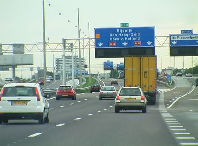
A4 motorway, highway in the Netherlands
The A4 is a motorway in the Netherlands that connects Amsterdam in the north to the Belgian border in the south, spanning approximately 125 kilometers through North Holland, South Holland, and North Brabant. The route passes through several tunnels such as the Schiphol and Benelux tunnels, which run beneath airport runways and rivers, and crosses major interchanges like Prins Clausplein in The Hague, where several key roads meet.
The A4 was first built in the late 1930s, with construction beginning before World War II and paused during the conflict, resuming after 1945. Since the 1960s and 70s, the road has been gradually expanded with additional lanes and tunnels, particularly following changes at Schiphol Airport and the growth of the Randstad region.
The A4 reflects the Dutch commitment to connecting major cities and enabling daily mobility across the country. Travelers along the route see the diversity of the landscape, from industrial zones to open polders, which reveals how commerce and geography shape the nation's development.
Drive on the A4 with care during peak hours, especially around major cities where traffic becomes noticeably heavier. Check current conditions before traveling, particularly near construction zones, and follow posted speed limits and special rush-hour lanes that help improve traffic flow.
A notable feature is the Ringvaart Aqueduct near Roelofarendsveen, built in 1961, which shows how water management is integrated into Dutch road construction. This structure reveals that the A4 is more than just a traffic route, as it passes through the country's complex water infrastructure system.
The community of curious travelers
AroundUs brings together thousands of curated places, local tips, and hidden gems, enriched daily by 60,000 contributors worldwide.