Enable Location

We need your location to show you interesting places around you

Discover nearby places

Find interesting locations and hidden gems around you

Precise directions

Get accurate directions and distances to places

Your location is never shared with other users. It's only used when you tap the location button.

Dingalan

Log in to your account

Start exploring — it's free

Trusted by 63,972 travelers worldwide

Continue with Google
Continue with Apple
or

We will send you a code to connect

By continuing, you accept our Terms and Conditions and our Privacy Policy

Check your inbox

We've sent a pincode in your inbox. Please enter the code below.

Discussion Reviews 1 Photos
19.1k Popularity

Dingalan, municipality of the Philippines in the province of Aurora

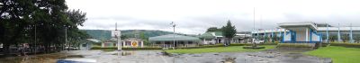
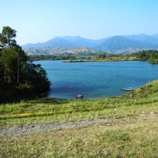
Dingalan is a municipality in Aurora Province, Philippines, surrounded by Sierra Madre mountains and the sea. The town sits on hilly terrain with multiple slopes and is divided into eleven local barangay communities.

The town was officially established in 1962 and grew as a small municipal center. The area remained relatively remote due to its mountainous terrain, preserving its natural character over the decades.

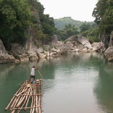
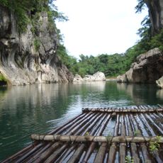
The name Dingalan comes from local language meaning "place of rocks". People here depend on fishing and farming, and this way of life is visible in how the town is built and how residents spend their days working with the land and sea.

Trails to viewpoints and beaches are walkable with moderate difficulty suitable for most people, though it helps to hire a local guide for navigation. Bring your own food since dining options near attractions are limited.

A lighthouse sits on a rocky hillside overlooking White Beach, reachable via a forest trail with ocean views along the way. Many visitors overlook this moderate walk despite it offering one of the best coastal views in the area.

The community of curious travelers

AroundUs brings together thousands of curated places, local tips, and hidden gems, enriched daily by 60,000 contributors worldwide.

Start exploring
Location
Inception
June 16, 1956
Elevation above the sea
272 m
Shares border with
San Luis, General Nakar, Doña Remedios Trinidad, General Tinio, Gabaldon
GPS coordinates
15.38333,121.40000
Latest update
February 16, 2026 23:00
Around this place
Biak-na-Bato National Park
Philippines

Biak-na-Bato National Park

44.8 km
Minalungao National Park
Philippines

Minalungao National Park

28.8 km
Cabanatuan American Memorial
Philippines

Cabanatuan American Memorial

40.7 km
Aurora Memorial National Park
Philippines

Aurora Memorial National Park

32.3 km
Cabanatuan Cathedral
Philippines

Cabanatuan Cathedral

48.2 km
Saint Francis of Assisi Parish Church
Philippines

Saint Francis of Assisi Parish Church

42.9 km
Baler Church
Philippines

Baler Church

45.3 km
Death Place of General Antonio Luna historical marker
Philippines

Death Place of General Antonio Luna historical marker

48.3 km
Doña Aurora Aragon-Quezon House
Philippines

Doña Aurora Aragon-Quezon House

45.3 km
Church of Baler historical marker
Philippines

Church of Baler historical marker

45.3 km
Nueva Ecija High School historical marker
Philippines

Nueva Ecija High School historical marker

47.6 km
Dikaloyungan historical marker
Philippines

Dikaloyungan historical marker

43.7 km
Lt. Gilmore Rescue Party historical marker
Philippines

Lt. Gilmore Rescue Party historical marker

45.3 km
Biyaknabato historical marker
Philippines

Biyaknabato historical marker

46.7 km
Aurora Aragon Quezon historical marker
Philippines

Aurora Aragon Quezon historical marker

45.3 km
Siege of the Church of Baler historical marker
Philippines

Siege of the Church of Baler historical marker

45.3 km
Birthplace of Manuel Luis Quezon historical marker
Philippines

Birthplace of Manuel Luis Quezon historical marker

45.3 km
Town of Baler historical marker
Philippines

Town of Baler historical marker

45.3 km
Baler Municipal Hall
Philippines

Baler Municipal Hall

45.3 km
Memorare historical marker (Raid at Cabanatuan)
Philippines

Memorare historical marker (Raid at Cabanatuan)

40.8 km
Church of San Miguel de Mayumo historical marker
Philippines

Church of San Miguel de Mayumo historical marker

52.9 km
Felipe Buencamino, Sr. historical marker
Philippines

Felipe Buencamino, Sr. historical marker

52.4 km
Church of Peñaranda historical marker
Philippines

Church of Peñaranda historical marker

42.8 km
Penyaranda historical marker
Philippines

Penyaranda historical marker

41.5 km
Lazaro Francisco historical marker
Philippines

Lazaro Francisco historical marker

48.7 km
General Manuel Tinio historical marker
Philippines

General Manuel Tinio historical marker

48.6 km
Dreamwater Resort
Philippines

Dreamwater Resort

44 km
Quezon Park
Philippines

Quezon Park

45.4 km
Show the full map
Reviews
Share your experience

No review yet

Discussions
Start a discussion...

No discussion yet

« Dingalan - municipality of the Philippines in the province of Aurora » is provided by Around Us (aroundus.com). Images and texts are derived from Wikimedia project under a Creative Commons license. You are allowed to copy, distribute, and modify copies of this page, under the conditions set by the license, as long as this note is clearly visible.

Discover hidden gems everywhere you go!

From secret cafés to breathtaking viewpoints, skip the crowded tourist spots and find places that match your style. Our app makes it easy with voice search, smart filtering, route optimization, and insider tips from travelers worldwide. Download now for the complete mobile experience.

Around Us App Screenshot

A unique approach to discovering new places

Le Figaro

All the places worth exploring

France Info

A tailor-made excursion in just a few clicks

20 Minutes

Around Us
Travel Guide & Maps
Download

Send to your phone

QR Code
1

Open the camera app on your mobile.

2

Point at the QR code with your camera. A notification will appear.

3

Tap the notification to open the link.