Mount Arayat, Extinct volcano in Pampanga, Philippines
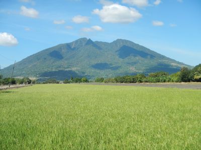
Mount Arayat is an extinct volcano rising 1,033 meters above the plains of Central Luzon, with a collapsed crater visible on its northwestern side. Dense forest covers the lower slopes, while the summit area shows rocky terrain with less vegetation.
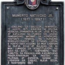
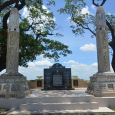
Revolutionaries used the mountain as a retreat in September 1896 following their uprising against Spanish rule in the Nueva Ecija region. These forested slopes provided shelter and cover during the struggle for Philippine independence.
The mountain takes its name from the town of Arayat at the base of its southern slopes. Hikers encounter small chapels and wooden crosses along the trails, placed by pilgrims over time.
The southern trail begins in Arayat town and passes through forest sections toward the summit, while the northern path starts from Pampanga State Agricultural University. Hikers should set out early in the morning, as the sun grows strong by midday and shade becomes scarce.
The peak stands alone amid the flat rice fields of Central Luzon and can be seen from far away, sometimes from distances beyond 70 kilometers (43 miles). On clear days, people in the region use its silhouette for orientation.
Location: Central Luzon
Location: Pampanga
Location: Arayat
Elevation above the sea: 1,026 m
GPS coordinates: 15.20129,120.74311
Latest update: December 5, 2025 16:37
Angeles Church
18 km
San Andres Apostol Church
15.2 km
Paskuhan Village
17.7 km
Magalang Church
9 km
Santa Catalina Parish Church
6.4 km
San Luis Gonzaga Parish Church
18.7 km
Pamintuan Mansion historical marker
17.9 km
Cuyugan-Dayrit House
19.4 km
Mount Arayat National Park
187 m
Mariano Llanera historical marker
13.8 km
House of Angel Pantaleon de Miranda historical marker
18.1 km
Church of Angeles historical marker
18 km
Museum of Angeles City
17.9 km
Pamintuan Mansion
17.9 km
Pamintuan Mansion
17.9 km
The House of the Aquino Family historical marker
16.5 km
Aquino Ancestral House
16.5 km
Servillano Aquino historical marker
16.6 km
Mamerto Natividad Jr. historical marker
13.8 km
The Church of Santa Ana historical marker
12.1 km
Renato D. Tayag historical marker
17.9 km
Museum of Philippine Social History
17.9 km
Dayrit House historical marker
19.4 km
Artillery Memorial historical marker
18.2 km
Angeles City Library and Information Center
17.9 km
Magalang historical marker
9 km
Diosdado P. Macapagal historical marker
6.4 km
Angel Pantaleon de Miranda House
18.1 kmReviews
Visited this place? Tap the stars to rate it and share your experience / photos with the community! Try now! You can cancel it anytime.
Discover hidden gems everywhere you go!
From secret cafés to breathtaking viewpoints, skip the crowded tourist spots and find places that match your style. Our app makes it easy with voice search, smart filtering, route optimization, and insider tips from travelers worldwide. Download now for the complete mobile experience.
A unique approach to discovering new places❞
— Le Figaro
All the places worth exploring❞
— France Info
A tailor-made excursion in just a few clicks❞
— 20 Minutes