Enable Location

We need your location to show you interesting places around you

Discover nearby places

Find interesting locations and hidden gems around you

Precise directions

Get accurate directions and distances to places

Your location is never shared with other users. It's only used when you tap the location button.

Fort Magsaysay

Log in to your account

Start exploring — it's free

Trusted by 61,509 travelers worldwide

Continue with Google
Continue with Apple
or

We will send you a code to connect

By continuing, you accept our Terms and Conditions and our Privacy Policy

Check your inbox

We've sent a pincode in your inbox. Please enter the code below.

Fort Magsaysay

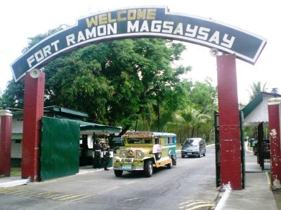
Fort Magsaysay, Military training base in Palayan City, Philippines.

Description

Fort Magsaysay is a military training base in Palayan that spans across a large area containing training grounds, barracks, administrative offices, and an operational airfield. The facility also houses rehabilitation centers and serves various operational needs for the armed forces.

History

President Ramon Magsaysay established the military reservation in 1955 as a training facility for large-scale exercises. Over the decades, the base expanded and took on various military and government functions.

Culture

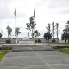
The Aquino-Diokno Memorial preserves detention cells from the Martial Law era, allowing visitors to see where significant political moments unfolded. Walking through these spaces offers a direct connection to a complex chapter in Philippine history.

Practical

The base can be reached via two main roads, though certain areas require special permission to enter. Visitors should check access requirements ahead of time and allow extra time for any authorization processes.

Did you know?

The base houses a specialized drug treatment and rehabilitation center that has developed therapeutic programs over many years. This facility is less widely known than the site's historical aspects but represents an important part of its current mission.

Location
Inception
December 19, 1955
Elevation above the sea
75.85 m
Operator
Armed Forces of the Philippines
GPS coordinates
15.43389,121.08722
Latest update
December 7, 2025 19:24

AroundUs brings together thousands of curated places, local tips, and hidden gems, enriched daily by 60,000 contributors worldwide. Discover all places nearby (Palayan).

Around this place
Biak-na-Bato National Park
Philippines

Biak-na-Bato National Park

34.9 km
Minalungao National Park
Philippines

Minalungao National Park

15.4 km
Cabanatuan American Memorial
Philippines

Cabanatuan American Memorial

9.6 km
Aurora Memorial National Park
Philippines

Aurora Memorial National Park

37 km
Cabanatuan Cathedral
Philippines

Cabanatuan Cathedral

14.6 km
Sideco House
Philippines

Sideco House

23.9 km
Saint Francis of Assisi Parish Church
Philippines

Saint Francis of Assisi Parish Church

12.8 km
Mariano Llanera historical marker
Philippines

Mariano Llanera historical marker

31.6 km
Dr. Maximo Viola historical marker
Philippines

Dr. Maximo Viola historical marker

35.1 km
Death Place of General Antonio Luna historical marker
Philippines

Death Place of General Antonio Luna historical marker

14.6 km
Nueva Ecija High School historical marker
Philippines

Nueva Ecija High School historical marker

14 km
Jose P. Bantug historical marker
Philippines

Jose P. Bantug historical marker

24 km
Biyaknabato historical marker
Philippines

Biyaknabato historical marker

36.1 km
Trinidad Tecson historical marker
Philippines

Trinidad Tecson historical marker

35.3 km
Simon Tecson historical marker
Philippines

Simon Tecson historical marker

35.2 km
Mamerto Natividad Jr. historical marker
Philippines

Mamerto Natividad Jr. historical marker

31.6 km
Memorare historical marker (Raid at Cabanatuan)
Philippines

Memorare historical marker (Raid at Cabanatuan)

9.8 km
Central Luzon State University historical marker
Philippines

Central Luzon State University historical marker

37.1 km
Church of San Miguel de Mayumo historical marker
Philippines

Church of San Miguel de Mayumo historical marker

34.7 km
Francisco Makabulos historical marker
Philippines

Francisco Makabulos historical marker

38.3 km
Felipe Buencamino, Sr. historical marker
Philippines

Felipe Buencamino, Sr. historical marker

34.3 km
Penyaranda historical marker
Philippines

Penyaranda historical marker

10.9 km
Church of Peñaranda historical marker
Philippines

Church of Peñaranda historical marker

12.8 km
Lazaro Francisco historical marker
Philippines

Lazaro Francisco historical marker

15 km
Epifanio de los Santos historical marker
Philippines

Epifanio de los Santos historical marker

23.9 km
General Manuel Tinio historical marker
Philippines

General Manuel Tinio historical marker

14.7 km
San Isidro historical marker
Philippines

San Isidro historical marker

23.8 km
Battle of San Isidro historical marker
Philippines

Battle of San Isidro historical marker

23.9 km
Show the full map
« Fort Magsaysay - Military training base in Palayan City, Philippines » is provided by Around Us (aroundus.com). Images and texts are derived from Wikimedia project under a Creative Commons license. You are allowed to copy, distribute, and modify copies of this page, under the conditions set by the license, as long as this note is clearly visible.

Discover hidden gems everywhere you go!

From secret cafés to breathtaking viewpoints, skip the crowded tourist spots and find places that match your style. Our app makes it easy with voice search, smart filtering, route optimization, and insider tips from travelers worldwide. Download now for the complete mobile experience.

Around Us App Screenshot

A unique approach to discovering new places

Le Figaro

All the places worth exploring

France Info

A tailor-made excursion in just a few clicks

20 Minutes

Around Us
Travel Guide & Maps
Download

Send to your phone

QR Code
1

Open the camera app on your mobile.

2

Point at the QR code with your camera. A notification will appear.

3

Tap the notification to open the link.