Roosevelt Protected Landscape, Protected landscape in Central Luzon, Philippines.
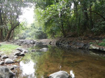
Roosevelt Protected Landscape is a protected area covering about 786 hectares of grasslands and older forest at the base of Mount Santa Rita and Mount Malasimbo in Bataan province. The terrain combines open grassland with woodland sections, creating different habitats within the same space.
The area was established in 1933 when Governor-General Theodore Roosevelt Jr. signed a proclamation creating this as a protected national space at roughly 1,485 hectares. The site has since been reduced in size through administrative changes to focus protection efforts.
The area serves as a link between local communities and the forest, where traditional land management practices remain visible in how the landscape is shaped and used. Visitors can observe how the grasslands and woodlands support both wildlife and local livelihoods.
The area is accessible via the Subic-Clark-Tarlac Expressway, with the Tipo Toll Barrier located near the southwestern edge of the grounds. Visitors should bring sturdy footwear and water, as walking covers varied terrain.
The landscape harbors pythons, monitor lizards, cloud rats, and birds such as kingfishers and flycatchers within mahogany and teak plantations. This blend of planted forest and wild animals is uncommon in the broader region.
The community of curious travelers
AroundUs brings together thousands of curated places, local tips, and hidden gems, enriched daily by 60,000 contributors worldwide.