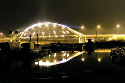
Madaliński Bridge in Ostrołęka, Road bridge spanning the Narew River in Ostrołęka, Poland.
The Madaliński Bridge is a road structure with four spans and an iron tied arch design crossing the Narew River. It carries both vehicle traffic and pedestrians while linking different sections of the town.
The structure was named after General Antoni Madaliński, who commanded Polish forces in the late 18th century. This naming honors a significant figure from an important period in regional history.
The structure is part of daily life for locals who cross it regularly on their way through town. It connects neighborhoods and marks an important point in the landscape of the area.
You can cross the bridge on foot or by vehicle and should be aware of traffic during busy times. Access is available from both sides and is designed to accommodate pedestrians comfortably.
The four-span design with an iron tied arch shows careful engineering from an earlier period of bridge building. This construction method was advanced for its time and demonstrates solid craftsmanship.
Location: Ostrołęka
GPS coordinates: 53.08540,21.56390
Latest update: December 14, 2025 18:04
St. Anthony's Church, Ostrołęka
523 m
Church of the Visitation in Ostrołęka
343 m
Mauzoleum bitwy pod Ostrołęką
510 m
Church of Saint Francis of Assisi in Ostrołęka
2.5 km
Church of Christ the Redeemer in Ostrołęka
1.6 km
Church of Saint Adalbert of Prague in Ostrołęka
4.2 km
Muzeum Kultury Kurpiowskiej
199 m
Kościół Najświętszego Serca Pana Jezusa w Rzekuniu
5.8 km
Ławeczka Józefa Psarskiego w Ostrołęce
457 m
Ostrołęka Town Hall
282 m
Muzeum Żołnierzy Wyklętych w Ostrołęce
1.2 km
Culture Museum Kurpiowska
200 m
Pomnik Mauzoleum żołnierzy poległych w bitwie pod Ostrołęką 26 maja 1831 roku
566 m
Pomnik-mauzoleum w Ostrołęce
568 m
Zespół klasztorny bernardynów, gen. Ludwika Bogusławskiego 20 w Ostrołęce
515 m
Sacred Heart church in Rzekuń
5.8 km
Zespół urbanistyczny Starego Miasta (w granicach: rz. Narew - ul. Bogusławskiego - Kopernika, zespół kościelny - ul. Batorego - Pstrowskiego)
378 m
Zespół fortyfikacji ziemnych Fortu Bema
509 m
Dom, XIX/XX (rekonstrukcja)
587 m
Zespół dworski
7.6 km
Manor in Stary Susk
7.6 km
Budynek koszarowy
4 km
Pl. Gen. Bema 8
200 m
Pl. Gen. Bema 4
267 m
Budynek starostwa
270 m
Zespół dworski
10.7 km
Plebania
10 km
Budynek koszarowy, al. Wojska Polskiego 28 w Ostrołęce
3.6 kmVisited this place? Tap the stars to rate it and share your experience / photos with the community! Try now! You can cancel it anytime.
Discover hidden gems everywhere you go!
From secret cafés to breathtaking viewpoints, skip the crowded tourist spots and find places that match your style. Our app makes it easy with voice search, smart filtering, route optimization, and insider tips from travelers worldwide. Download now for the complete mobile experience.
A unique approach to discovering new places❞
— Le Figaro
All the places worth exploring❞
— France Info
A tailor-made excursion in just a few clicks❞
— 20 Minutes