Enable Location

We need your location to show you interesting places around you

Discover nearby places

Find interesting locations and hidden gems around you

Precise directions

Get accurate directions and distances to places

Your location is never shared with other users. It's only used when you tap the location button.

Beloy Lake, Altai Krai

Log in to your account

Start exploring — it's free

Trusted by 66,047 travelers worldwide

Continue with Google
Continue with Apple
or

We will send you a code to connect

By continuing, you accept our Terms and Conditions and our Privacy Policy

Check your inbox

We've sent a pincode in your inbox. Please enter the code below.

Discussion Reviews 1 Photos
5.8k Popularity

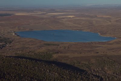
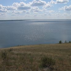
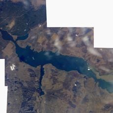
Beloy Lake, Altai Krai, Protected lake in Altai Krai, Russia.

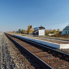
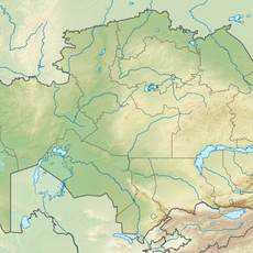
Beloy Lake is a protected lake and natural monument in Altai Krai, located in the southern part of Western Siberia, Russia. It sits in a flat to gently rolling landscape where open plains meet low ridges, with reeds and natural vegetation along much of its shoreline.

Russian settlers reached the Altai region in the late 1600s and gradually built communities near lakes like this one. The lake's protected status was established during the Soviet period, when natural water bodies across Siberia were formally registered and managed.

The name Beloy comes from the Russian word for "white," likely referring to how the water looks under bright daylight. Local fishermen have worked this lake for generations and still follow traditional methods within the rules of the protected area.

The lake is most comfortable to visit in summer, when paths around the shore are in good condition and the weather is more stable. Because it is a protected area, visitors should follow the signs on site, which may restrict access to certain zones or regulate behavior near sensitive areas.

Although the lake is listed as a natural monument, it also functions as an active research site where scientists track changes in Siberian freshwater ecosystems over long periods. This kind of long-term monitoring is uncommon in the region, making it a reference point for environmental researchers.

The community of curious travelers

AroundUs brings together thousands of curated places, local tips, and hidden gems, enriched daily by 60,000 contributors worldwide.

Start exploring
GPS coordinates
51.29444,82.64722
Latest update
March 3, 2026 22:41
Around this place
Denisova Cave
Russian Federation

Denisova Cave

141.5 km
West-Altay State Nature Reserve
Kazakhstan

West-Altay State Nature Reserve

147 km
Tigireksky Nature Reserve
Russian Federation

Tigireksky Nature Reserve

44.7 km
Okladnikov Cave
Russian Federation

Okladnikov Cave

107.9 km
Usine de taille de pierre de Kolyvan
Russian Federation

Usine de taille de pierre de Kolyvan

5.9 km
Abai Literary Memorial Museum
Kazakhstan

Abai Literary Memorial Museum

194.8 km
Алтайский оптико-лазерный центр имени Г. С. Титова
Russian Federation

Алтайский оптико-лазерный центр имени Г. С. Титова

34.9 km
Gilevskoye Vodokhranilishche
Russian Federation

Gilevskoye Vodokhranilishche

56.4 km
Boris Alexandrov Sport Palace
Kazakhstan

Boris Alexandrov Sport Palace

148.9 km
Chagyrskaya Cave
Russian Federation

Chagyrskaya Cave

39 km
Schülbi-Talsperre
Kazakhstan

Schülbi-Talsperre

140.2 km
Ust-Kanskaya cave
Russian Federation

Ust-Kanskaya cave

156.8 km
Stronger Than Death
Kazakhstan

Stronger Than Death

195.4 km
Stadion Spartak w Semeju
Kazakhstan

Stadion Spartak w Semeju

195.4 km
Zhambili Regional Drama Theatre
Kazakhstan

Zhambili Regional Drama Theatre

150 km
Oskemen Reservoir
Kazakhstan

Oskemen Reservoir

154.6 km
Kazakhstan

Novoshūl'ba Aūdany

124 km
Vostok Stadium
Kazakhstan

Vostok Stadium

147.5 km
Saint Andrew Orthodox cathedral in Oskemen
Kazakhstan

Saint Andrew Orthodox cathedral in Oskemen

150.1 km
Музейна печера (Росія)
Russian Federation

Музейна печера (Росія)

139.6 km
Дёминская церковь имени Казанской Божьей Матери
Russian Federation

Дёминская церковь имени Казанской Божьей Матери

148.5 km
Kolos, Novoalexandrovsky Selsoviet, Rubtsovsky District, Altai Krai
Russian Federation

Kolos, Novoalexandrovsky Selsoviet, Rubtsovsky District, Altai Krai

105.4 km
Traktorny
Russian Federation

Traktorny

102.3 km
Шиловський (Калманський район)
Russian Federation

Шиловський (Калманський район)

190.3 km
Дальній (Ребріхинський район)
Russian Federation

Дальній (Ребріхинський район)

192.7 km
Паново (селище, Ребріхинський район)
Russian Federation

Паново (селище, Ребріхинський район)

193.5 km
Zarnitsa
Russian Federation

Zarnitsa

101.7 km
Oktyabr'skiy Rayon
Kazakhstan

Oktyabr'skiy Rayon

147.8 km
Show the full map
Reviews
Share your experience

No review yet

Discussions
Start a discussion...

No discussion yet

« Beloy Lake, Altai Krai - Protected lake in Altai Krai, Russia » is provided by Around Us (aroundus.com). Images and texts are derived from Wikimedia project under a Creative Commons license. You are allowed to copy, distribute, and modify copies of this page, under the conditions set by the license, as long as this note is clearly visible.

Discover hidden gems everywhere you go!

From secret cafés to breathtaking viewpoints, skip the crowded tourist spots and find places that match your style. Our app makes it easy with voice search, smart filtering, route optimization, and insider tips from travelers worldwide. Download now for the complete mobile experience.

Around Us App Screenshot

A unique approach to discovering new places

Le Figaro

All the places worth exploring

France Info

A tailor-made excursion in just a few clicks

20 Minutes

Around Us
Travel Guide & Maps
Download

Send to your phone

QR Code
1

Open the camera app on your mobile.

2

Point at the QR code with your camera. A notification will appear.

3

Tap the notification to open the link.