Enable Location

We need your location to show you interesting places around you

Discover nearby places

Find interesting locations and hidden gems around you

Precise directions

Get accurate directions and distances to places

Your location is never shared with other users. It's only used when you tap the location button.

Gilevskoye Vodokhranilishche

Log in to your account

Start exploring — it's free

Trusted by 64,709 travelers worldwide

Continue with Google
Continue with Apple
or

We will send you a code to connect

By continuing, you accept our Terms and Conditions and our Privacy Policy

Check your inbox

We've sent a pincode in your inbox. Please enter the code below.

Gilevskoye Vodokhranilishche
Discussion Reviews 1 Photos
4.2k Popularity

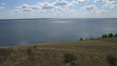
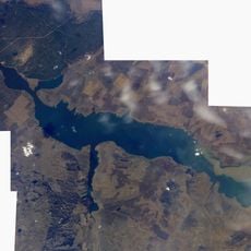
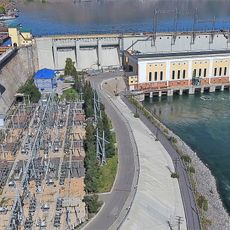
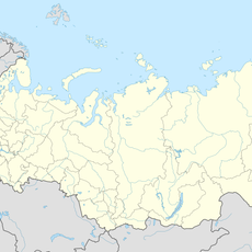
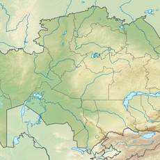
Gilevskoye Vodokhranilishche, reservoir in Russia

Gilevskoye Vodokhranilishche is a reservoir in Russia, formed by damming a river to supply water for local communities and agricultural land in the surrounding region. It sits within a flat, open landscape with gentle hills in the distance and a broad water surface that changes in size depending on the season.

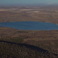
The reservoir was created in the 20th century when a dam was built across a river to secure a reliable water supply for the region and support agricultural development. That construction fundamentally altered the course of the river and brought a new water source to the surrounding communities.

The Gilevskoye reservoir sits in a flat, open landscape and serves as a familiar spot for fishing and spending time outdoors for people from nearby villages. Early mornings and evenings tend to draw locals to the shoreline with fishing rods and folding chairs.

The site can be reached from nearby towns along mostly unpaved roads, and a standard vehicle is usually enough to get close to the water. Visiting in spring or early summer tends to offer better conditions, as the water level is higher and the surrounding land is greener.

During dry periods or high-demand seasons, water is released from the reservoir, exposing stretches of shoreline that are normally submerged. Visitors who come at these times can make out the outline of the original riverbed that lies hidden beneath the water the rest of the year.

The community of curious travelers

AroundUs brings together thousands of curated places, local tips, and hidden gems, enriched daily by 60,000 contributors worldwide.

Start exploring
GPS coordinates
51.09583,81.90389
Latest update
March 3, 2026 10:06
Around this place
West-Altay State Nature Reserve
Kazakhstan

West-Altay State Nature Reserve

176.7 km
Tigireksky Nature Reserve
Russian Federation

Tigireksky Nature Reserve

76.8 km
Semipalatinsk Bridge
Kazakhstan

Semipalatinsk Bridge

140.8 km
State Forest Nature Reservat "Semey Ormany"
Kazakhstan

State Forest Nature Reservat "Semey Ormany"

143.6 km
Beloy Lake, Altai Krai
Russian Federation

Beloy Lake, Altai Krai

56.4 km
Okladnikov Cave
Russian Federation

Okladnikov Cave

164.2 km
Usine de taille de pierre de Kolyvan
Russian Federation

Usine de taille de pierre de Kolyvan

52.7 km
Abai Literary Memorial Museum
Kazakhstan

Abai Literary Memorial Museum

139 km
Алтайский оптико-лазерный центр имени Г. С. Титова
Russian Federation

Алтайский оптико-лазерный центр имени Г. С. Титова

33.3 km
Boris Alexandrov Sport Palace
Kazakhstan

Boris Alexandrov Sport Palace

136.5 km
Chagyrskaya Cave
Russian Federation

Chagyrskaya Cave

95.3 km
Schülbi-Talsperre
Kazakhstan

Schülbi-Talsperre

94.8 km
East Kazakhstan Regional Museum of Fine Arts Named for the Nevzorov family
Kazakhstan

East Kazakhstan Regional Museum of Fine Arts Named for the Nevzorov family

139.6 km
Stronger Than Death
Kazakhstan

Stronger Than Death

139.6 km
Stadion Spartak w Semeju
Kazakhstan

Stadion Spartak w Semeju

139.5 km
Zhambili Regional Drama Theatre
Kazakhstan

Zhambili Regional Drama Theatre

137.6 km
Oskemen Reservoir
Kazakhstan

Oskemen Reservoir

144.6 km
Kazakhstan

Novoshūl'ba Aūdany

72.8 km
Cathedral of the Resurrection
Kazakhstan

Cathedral of the Resurrection

140.1 km
Vostok Stadium
Kazakhstan

Vostok Stadium

134.3 km
Saint Andrew Orthodox cathedral in Oskemen
Kazakhstan

Saint Andrew Orthodox cathedral in Oskemen

137.1 km
The Peter and Paul Abalatsko-Znamensky Monastery
Kazakhstan

The Peter and Paul Abalatsko-Znamensky Monastery

141.7 km
Kolos, Novoalexandrovsky Selsoviet, Rubtsovsky District, Altai Krai
Russian Federation

Kolos, Novoalexandrovsky Selsoviet, Rubtsovsky District, Altai Krai

62.8 km
Traktorny
Russian Federation

Traktorny

70.7 km
Zarnitsa
Russian Federation

Zarnitsa

73.8 km
Oktyabr'skiy Rayon
Kazakhstan

Oktyabr'skiy Rayon

136.8 km
Natural Monument "Sinegorskaya firry grove"
Kazakhstan

Natural Monument "Sinegorskaya firry grove"

188.7 km
Metallurgists' Palace of Culture
Kazakhstan

Metallurgists' Palace of Culture

134 km
Show the full map
Reviews
Share your experience

No review yet

Discussions
Start a discussion...

No discussion yet

« Gilevskoye Vodokhranilishche - reservoir in Russia » is provided by Around Us (aroundus.com). Images and texts are derived from Wikimedia project under a Creative Commons license. You are allowed to copy, distribute, and modify copies of this page, under the conditions set by the license, as long as this note is clearly visible.

Discover hidden gems everywhere you go!

From secret cafés to breathtaking viewpoints, skip the crowded tourist spots and find places that match your style. Our app makes it easy with voice search, smart filtering, route optimization, and insider tips from travelers worldwide. Download now for the complete mobile experience.

Around Us App Screenshot

A unique approach to discovering new places

Le Figaro

All the places worth exploring

France Info

A tailor-made excursion in just a few clicks

20 Minutes

Around Us
Travel Guide & Maps
Download

Send to your phone

QR Code
1

Open the camera app on your mobile.

2

Point at the QR code with your camera. A notification will appear.

3

Tap the notification to open the link.