Chest opened
+${chestReward.xp} XP
Explorer
NOUVEAU ×${chestReward.collectible.quantity}
tapez pour fermer
Chest locked

Open chests in the app

Around Us is built for your phone — chests unlock when you walk, explore and capture nearby places.

Enable Location

We need your location to show you interesting places around you

Discover nearby places

Find interesting locations and hidden gems around you

Precise directions

Get accurate directions and distances to places

Your location is never shared with other users. It's only used when you tap the location button.

Log in to your account

Start exploring — it's free

Trusted by 73,011 travelers worldwide

Continue with Google
Continue with Apple
or

We will send you a code to connect

By continuing, you accept our Terms and Conditions and our Privacy Policy

Check your inbox

We've sent a pincode in your inbox. Please enter the code below.

Рождественское городище
Discussion Reviews Photo
1.5k Popularity

Рождественское городище, Medieval hillfort in Karagaysky District, Russia

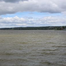
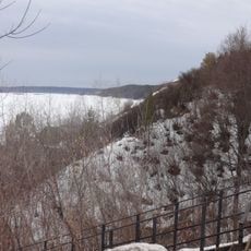
Rождественское городище is a fortified settlement from the early medieval period situated on elevated ground overlooking the Obva River. The site features defensive earthworks including ramparts and ditches arranged across a large area to protect the inner structures.

The site was founded by Finno-Ugric peoples in the 10th century as a settlement on the river. It later developed into a major trading hub called Kassaba Afkula that played a key role within the Volga Bulgaria state.

The settlement was a crossroads where different groups left behind their artistic traditions, visible in bronze ornaments and decorative objects with regional design styles. These finds show how various peoples shared this place and influenced each other over time.

The site experiences ongoing natural erosion due to river activity and is regularly explored through fieldwork. Visitors should be prepared for uneven terrain and open excavation areas.

A seal ring discovered at the site bears the name of an Islamic trader, revealing unexpected connections to Arab trading networks. This finding shows how far-reaching commercial links extended during this period.

The community of curious travelers

AroundUs brings together thousands of curated places, local tips, and hidden gems, enriched daily by 60,000 contributors worldwide.

Start exploring
Inception
10 century
GPS coordinates
58.49671,55.27194
Latest update
December 9, 2025 20:20
Around this place
Kama dam
Russian Federation

Kama dam

75 km
Kama Reservoir
Russian Federation

Kama Reservoir

74.9 km
Khokhlovka
Russian Federation

Khokhlovka

63.5 km
Kommunalny Bridge
Russian Federation

Kommunalny Bridge

76.8 km
Chusovskoy Bridge
Russian Federation

Chusovskoy Bridge

76.7 km
Krasavinsky bridge
Russian Federation

Krasavinsky bridge

70.1 km
Holy Trinity Cathedral
Russian Federation

Holy Trinity Cathedral

77.3 km
Railway Bridge in Perm
Russian Federation

Railway Bridge in Perm

74.3 km
Armored boat AK-454
Russian Federation

Armored boat AK-454

68.3 km
Park of Stones
Russian Federation

Park of Stones

76.8 km
Prud Nytvinskiy
Russian Federation

Prud Nytvinskiy

61.2 km
Botanical garden of Perm State University
Russian Federation

Botanical garden of Perm State University

76.4 km
Кудымкарское городище
Russian Federation

Кудымкарское городище

67.9 km
Garden square named after Dzerzhinsky
Russian Federation

Garden square named after Dzerzhinsky

77.1 km
Собор Рождества Богородицы
Russian Federation

Собор Рождества Богородицы

59.6 km
Храм Рождества Пресвятой Богородицы
Russian Federation

Храм Рождества Пресвятой Богородицы

66.9 km
Bust of Dzerzhinsky
Russian Federation

Bust of Dzerzhinsky

77.2 km
Добрянский историко-краеведческий музей
Russian Federation

Добрянский историко-краеведческий музей

66.8 km
Category:Saint Nicholas Orthodox church in Kudymkar
Russian Federation

Category:Saint Nicholas Orthodox church in Kudymkar

67.6 km
Kuzminka (Teploukhov's garden)
Russian Federation

Kuzminka (Teploukhov's garden)

25.2 km
Храм во имя всех святых (Нытва)
Russian Federation

Храм во имя всех святых (Нытва)

61 km
Сюзьва (разъезд)
Russian Federation

Сюзьва (разъезд)

36.1 km
1406-й км
Russian Federation

1406-й км

53.9 km
1402-й км
Russian Federation

1402-й км

49.3 km
1401-й км
Russian Federation

1401-й км

47.7 km
1403-й км
Russian Federation

1403-й км

50.5 km
Dvorets Kultury imeni Chekhova
Russian Federation

Dvorets Kultury imeni Chekhova

74.6 km
Port Baranyata
Russian Federation

Port Baranyata

47.7 km
Show the full map
Reviews
Share your experience

No review yet

Discussions
Start a discussion...

No discussion yet

« Рождественское городище - Medieval hillfort in Karagaysky District, Russia » is provided by Around Us (aroundus.com). Images and texts are derived from Wikimedia project under a Creative Commons license. You are allowed to copy, distribute, and modify copies of this page, under the conditions set by the license, as long as this note is clearly visible.

Discover hidden gems everywhere you go!

From secret cafés to breathtaking viewpoints, skip the crowded tourist spots and find places that match your style. Our app makes it easy with voice search, smart filtering, route optimization, and insider tips from travelers worldwide. Download now for the complete mobile experience.

Around Us App Screenshot

A unique approach to discovering new places

Le Figaro

All the places worth exploring

France Info

A tailor-made excursion in just a few clicks

20 Minutes

Around Us
Travel Guide & Maps
Download

Send to your phone

QR Code
1

Open the camera app on your mobile.

2

Point at the QR code with your camera. A notification will appear.

3

Tap the notification to open the link.