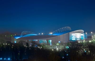
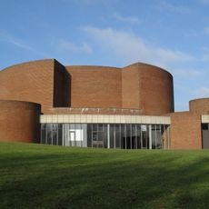
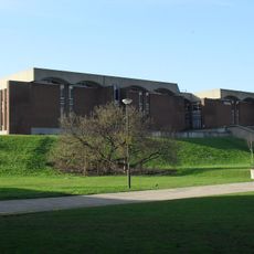
Brighton Community Stadium, Football stadium in Falmer, England
Brighton Community Stadium is a football and rugby venue in Falmer, east of Brighton. Three tiers of seating wrap around the playing surface, with part of the structure embedded into the natural slope of the land.
After losing their former ground the club Brighton & Hove Albion decided to build this new venue, with construction starting in 2008 and finishing in 2011. The first matchday took place that summer and marked a fresh beginning for the team.
Every matchday the venue becomes a meeting point for football supporters from across the region who gather on the terraces and walkways hours before kickoff. The team colors of blue and white dominate the scene and appear on banners, scarves and chants that echo through the stands.
Falmer railway station sits right next to the grounds and offers quick access from Brighton and surrounding towns. On matchdays several bus routes run from the city center to the entrance.
To control the local bird population trained birds of prey are deployed, keeping gulls and pigeons away and leaving the playing surface undisturbed. This method was introduced after problems with droppings and noise at earlier grounds.
Location: Moulsecoomb and Bevendean
Inception: 2008
Architects: KSS Design Group
Official opening: July 2011
Capacity: 31800
Address: Village Way, Brighton BN1 9BL
Website: http://amexstadium.co.uk
GPS coordinates: 50.86182,-0.08328
Latest update: December 5, 2025 06:40
Woodingdean Water Well
3 km
Stanmer Park
1.5 km
Stanmer House
1.6 km
Earthship Brighton
2.2 km
Hollingbury Castle
2.9 km
Stanmer Church
1.6 km
Moulsecoomb Place Halls
3 km
Gardner Arts Centre
560 m
Castle Hill, Brighton
2.8 km
Bevendean Down
2.5 km
Kingston Escarpment and Iford Hill
3.3 km
University of Sussex Library
618 m
The Parish Church of St Lawrence, Falmer
505 m
The Swan Inn
398 m
Brighton Extra Mural Cemetery Cemetery Chapel
3.8 km
Brighton And Preston Cemetery Mortuary Chapel
3.9 km
Falmer House Including Moat Within Courtyard
479 m
St Mary Magdalene
1.9 km
Lower Lodge (north)
684 m
Woodvale Cemetery Tomb Of John Frederick Ginnett
3.7 km
Woodingdean Library
2.9 km
Hollingbury Library
3.2 km
The Home Farmhouse
1.7 km
Tram Shelter Opposite The Junction With Surrenden Road
3.7 km
Woodvale Crematorium
3.7 km
Hodshrove Viaduct
2.2 km
Mathematical And Physical Sciences I Including Staircase To South And East To West Wing Attached To East Pevensey Building
463 m
Meeting House Including Kerbstones Surrounding Moat
487 mVisited this place? Tap the stars to rate it and share your experience / photos with the community! Try now! You can cancel it anytime.
Discover hidden gems everywhere you go!
From secret cafés to breathtaking viewpoints, skip the crowded tourist spots and find places that match your style. Our app makes it easy with voice search, smart filtering, route optimization, and insider tips from travelers worldwide. Download now for the complete mobile experience.
A unique approach to discovering new places❞
— Le Figaro
All the places worth exploring❞
— France Info
A tailor-made excursion in just a few clicks❞
— 20 Minutes