Williamsport Falls

Log in to your account

AroundUs is a community-driven map of interesting places, built by curious explorers like you. It grows with every review, story, and photo you share.
Connect to save your favorite spots, contribute locations, and create personalized routes.
Continue with Google
Continue with Apple
Continue with X
Continue with Facebook
Continue with email
By continuing, you accept our Terms and Conditions and our Privacy Policy
Create an account

Williamsport Falls

Add to collection
Map
Suggest a change
Share

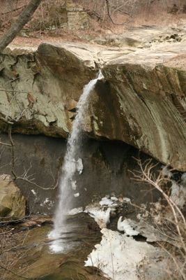
Williamsport Falls, Natural waterfall in Warren County, Indiana, US.

Williamsport Falls is a waterfall in Warren County, Indiana, that drops about 90 feet, making it the highest in the state. Water cascades over a thick sandstone ledge in a single impressive descent.

In the 1800s, water from the falls powered a local mill that served the community. The sandstone underlying the falls was also quarried for construction materials.

The falls serve as a natural focal point in Williamsport where photographers and nature lovers gather throughout the year. Visitors notice how the place draws people who want to experience the local landscape in person.

The easiest route is to follow Route 28 into Williamsport and turn onto Monroe Street, where parking sits near the fire station. Good footwear is helpful because the area near the falls can be slippery, especially after rain.

The water flow changes dramatically with the seasons and can dry up completely during dry periods. This variation results from modern farming and water management practices in the area.

Location: Warren County

GPS coordinates: 40.28614,-87.29263

Latest update: December 10, 2025 20:09

Photos
Around this place
Portland Arch Nature Preserve
United States of America

Portland Arch Nature Preserve

8.4 km
Glen Hall, Indiana
United States of America

Glen Hall, Indiana

22.7 km
Danville National Cemetery
United States of America

Danville National Cemetery

30.2 km
Oxford Presbyterian Church
United States of America

Oxford Presbyterian Church

26.2 km
Farmers Institute
United States of America

Farmers Institute

25.9 km
Fountain County Courthouse
United States of America

Fountain County Courthouse

18.9 km
Carnegie Library of Covington
United States of America

Carnegie Library of Covington

18.4 km
Williamsport-Washington Township Public Library
United States of America

Williamsport-Washington Township Public Library

299 m
Danville Branch, National Home for Disabled Volunteer Soldiers Historic District
United States of America

Danville Branch, National Home for Disabled Volunteer Soldiers Historic District

30.9 km
Warren County Courthouse
United States of America

Warren County Courthouse

250 m
Attica Downtown Historic District
United States of America

Attica Downtown Historic District

3.8 km
David S. Heath House
United States of America

David S. Heath House

26.2 km
Attica Main Street Historic District
United States of America

Attica Main Street Historic District

4 km
Williams Chapel
United States of America

Williams Chapel

17.7 km
Stidham United Methodist Church
United States of America

Stidham United Methodist Church

30.7 km
Marshall M. Milford House
United States of America

Marshall M. Milford House

4.1 km
Fountain County Clerk's Building
United States of America

Fountain County Clerk's Building

18.6 km
Brady Street Historic District
United States of America

Brady Street Historic District

3.7 km
West Lebanon-Pike Township Public Library
United States of America

West Lebanon-Pike Township Public Library

8.1 km
Covington Courthouse Square Historic District
United States of America

Covington Courthouse Square Historic District

18.8 km
Van Reed Farmstead
United States of America

Van Reed Farmstead

13.1 km
Covington Residential Historic District
United States of America

Covington Residential Historic District

18.5 km
William C.B. Sewell House
United States of America

William C.B. Sewell House

18.6 km
Kent and Hitchens Houses
United States of America

Kent and Hitchens Houses

591 m
Andrew Brier House
United States of America

Andrew Brier House

9.4 km
Old East Historic District
United States of America

Old East Historic District

3.7 km
Rob Roy Covered Bridge
United States of America

Rob Roy Covered Bridge

6.2 km
Cades Mill Bridge
United States of America

Cades Mill Bridge

24.8 km
Show the full map
Reviews

Visited this place? Tap the stars to rate it and share your experience / photos with the community! Try now! You can cancel it anytime.

« Williamsport Falls - Natural waterfall in Warren County, Indiana, US » is provided by Around Us (aroundus.com). Images and texts are derived from Wikimedia project under a Creative Commons license. You are allowed to copy, distribute, and modify copies of this page, under the conditions set by the license, as long as this note is clearly visible.

Discover hidden gems everywhere you go!

From secret cafés to breathtaking viewpoints, skip the crowded tourist spots and find places that match your style. Our app makes it easy with voice search, smart filtering, route optimization, and insider tips from travelers worldwide. Download now for the complete mobile experience.

Around Us App Screenshot

A unique approach to discovering new places

Le Figaro

All the places worth exploring

France Info

A tailor-made excursion in just a few clicks

20 Minutes