Enable Location

We need your location to show you interesting places around you

Discover nearby places

Find interesting locations and hidden gems around you

Precise directions

Get accurate directions and distances to places

Your location is never shared with other users. It's only used when you tap the location button.

Cahokia

Log in to your account

Start exploring — it's free

Trusted by 61,907 travelers worldwide

Continue with Google
Continue with Apple
or

We will send you a code to connect

By continuing, you accept our Terms and Conditions and our Privacy Policy

Check your inbox

We've sent a pincode in your inbox. Please enter the code below.

Cahokia, Archaeological site in East St. Louis, United States.

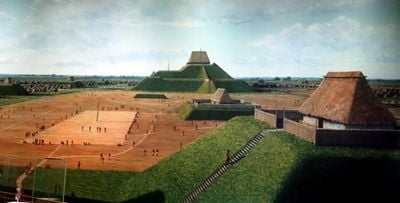
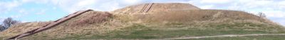
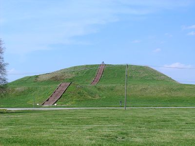
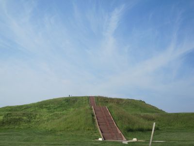
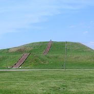
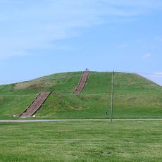
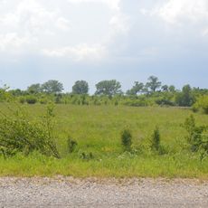
Cahokia is a pre-Columbian settlement site near Collinsville in Illinois consisting of about 80 preserved earthen monuments spread across roughly 900 hectares. The largest mound called Monks Mound reaches a height of 30 meters and covers around 6 hectares at its base.

Between the 7th and 14th centuries this location developed into the largest North American settlement north of Mexico before European arrival. The peak came in the 12th century when several thousand people likely lived here and traded with distant regions.

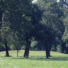
The ancient inhabitants built trade networks, crafted pottery and created gathering places for communal rituals. Today the preserved mound structures and artifacts illustrate how this society organized and used space for religious and social purposes.

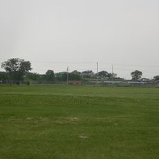
A museum operated by the Illinois Department of Natural Resources displays archaeological findings, offers educational programs and organizes guided walks around the site. The expansive grounds are best visited with sturdy footwear and can be explored easily on foot or by bicycle.

Archaeological evidence reveals advanced farming methods including raised fields and irrigation systems that enabled large-scale corn cultivation. A precisely aligned circle of wooden posts called Woodhenge apparently served as a solar calendar for agricultural and ceremonial purposes.

The community of curious travelers

AroundUs brings together thousands of curated places, local tips, and hidden gems, enriched daily by 60,000 contributors worldwide.

Start exploring
Location
Inception
1050
Operator
Illinois Department of Natural Resources
Part of
Mississippian culture
GPS coordinates
38.65389,-90.06444
Latest update
December 14, 2025 20:37
Historic and natural sites in Illinois

Illinois holds a rich collection of historical sites and natural landscapes. Visitors can explore prehistoric ruins like the Cahokia Mounds, where earthen structures reflect the achievements of ancient peoples. The region also features striking rock formations such as Garden of the Gods and natural...

Around this place
Monks Mound
United States of America

Monks Mound

787 m
World Wide Technology Raceway at Gateway
United States of America

World Wide Technology Raceway at Gateway

6.2 km
Mound 72
United States of America

Mound 72

381 m
Brooks Catsup Bottle Water Tower
United States of America

Brooks Catsup Bottle Water Tower

7.2 km
Spivey Building
United States of America

Spivey Building

8.8 km
United States of America

Mound 34

1 km
Horseshoe Lake State Park
United States of America

Horseshoe Lake State Park

4.4 km
Downtown East St. Louis Historic District
United States of America

Downtown East St. Louis Historic District

8.7 km
United States of America

Frank Holten State Recreation Area

7.4 km
Horseshoe Lake Mound and Village Site
United States of America

Horseshoe Lake Mound and Village Site

5.6 km
Mitchell Archaeological Site
United States of America

Mitchell Archaeological Site

5.6 km
Majestic Theatre
United States of America

Majestic Theatre

8.6 km
Collinsville Masonic Lodge Hall
United States of America

Collinsville Masonic Lodge Hall

6.9 km
Emmert-Zippel House
United States of America

Emmert-Zippel House

8.3 km
Miners Institute Building
United States of America

Miners Institute Building

6.9 km
Pennsylvania Avenue Historic District (East St. Louis, Illinois)
United States of America

Pennsylvania Avenue Historic District (East St. Louis, Illinois)

7.5 km
Daniel Dove Collins House
United States of America

Daniel Dove Collins House

6.5 km
Collinsville Aqua Park
United States of America

Collinsville Aqua Park

5.1 km
Cahokia Mounds Interpretive Center
United States of America

Cahokia Mounds Interpretive Center

462 m
State Bank Building
United States of America

State Bank Building

7 km
United States of America

Will Rogers Theater

7 km
United States of America

Arlington Greens Golf Course

6.9 km
United States of America

Gateway National Golf Links

7 km
Collinsville City Hall and Fire Station
United States of America

Collinsville City Hall and Fire Station

7 km
United States of America

Miners Theatre

6.9 km
United States of America

Steele

7.6 km
United States of America

Radish

5.1 km
United States of America

Work of art, statue

7 km
Show the full map
« Cahokia - Archaeological site in East St. Louis, United States » is provided by Around Us (aroundus.com). Images and texts are derived from Wikimedia project under a Creative Commons license. You are allowed to copy, distribute, and modify copies of this page, under the conditions set by the license, as long as this note is clearly visible.

Discover hidden gems everywhere you go!

From secret cafés to breathtaking viewpoints, skip the crowded tourist spots and find places that match your style. Our app makes it easy with voice search, smart filtering, route optimization, and insider tips from travelers worldwide. Download now for the complete mobile experience.

Around Us App Screenshot

A unique approach to discovering new places

Le Figaro

All the places worth exploring

France Info

A tailor-made excursion in just a few clicks

20 Minutes

Around Us
Travel Guide & Maps
Download

Send to your phone

QR Code
1

Open the camera app on your mobile.

2

Point at the QR code with your camera. A notification will appear.

3

Tap the notification to open the link.