Hubbard County

Log in to your account

AroundUs is a community-driven map of interesting places, built by curious explorers like you. It grows with every review, story, and photo you share.
Connect to save your favorite spots, contribute locations, and create personalized routes.
Continue with Google
Continue with Apple
Continue with X
Continue with Facebook
Continue with email
By continuing, you accept our Terms and Conditions and our Privacy Policy
Create an account
Add to collection
Map
Suggest a change
Share

Hubbard County, Administrative county in Minnesota, United States

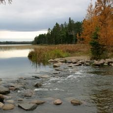
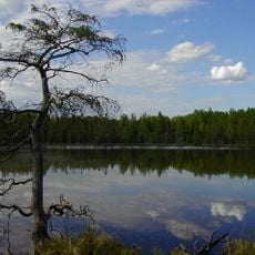
Hubbard County is an administrative county in northwestern Minnesota covering about 1,000 square miles. The landscape features rolling hills, dense forests, and numerous lakes and smaller ponds scattered throughout.

The county was established in 1883 and named after Lucius Frederick Hubbard, who served as Minnesota's governor from 1882 to 1887. This naming was typical of the era when newly formed administrative districts honored leading political figures.

The Leech Lake Indian Reservation occupies part of this area, and the Anishinaabe people maintain their communities and traditions here. You can see this heritage reflected in place names, seasonal gatherings, and how the land and water are respected.

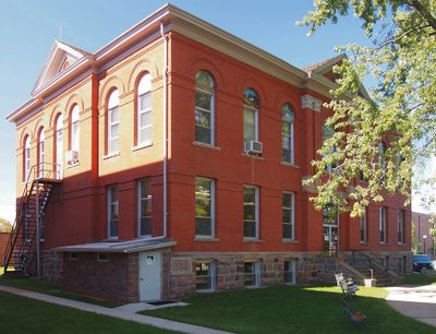
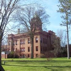
Park Rapids serves as the county seat, with the Government Center offering administrative services to residents and visitors. The area is accessible via several highways connecting various towns and communities throughout the region.

The county has a distinctive geographical feature where the northern portion slopes downward to the north while the southern section slopes downward to the south. This contrasting tilt creates two separate drainage patterns that shape the area's natural water flow.

Location: Minnesota

Inception: February 26, 1883

Capital city: Park Rapids

Shares border with: Beltrami County, Cass County, Wadena County, Becker County, Clearwater County

Website: http://co.hubbard.mn.us

GPS coordinates: 47.10000,-94.91000

Latest update: December 7, 2025 20:20

Photos
Around this place
Paul Bunyan and Babe the Blue Ox
United States of America

Paul Bunyan and Babe the Blue Ox

41.3 km
Itasca State Park
United States of America

Itasca State Park

27.4 km
Lake Bemidji State Park
United States of America

Lake Bemidji State Park

49.5 km
Waldsee
United States of America

Waldsee

52.7 km
Tamarac National Wildlife Refuge
United States of America

Tamarac National Wildlife Refuge

52.2 km
Paul Bunyan State Forest
United States of America

Paul Bunyan State Forest

16.9 km
Badoura State Forest
United States of America

Badoura State Forest

32.7 km
Nevis Tiger Muskie
United States of America

Nevis Tiger Muskie

15.9 km
Bemidji Carnegie Library
United States of America

Bemidji Carnegie Library

41.6 km
Beltrami County Courthouse
United States of America

Beltrami County Courthouse

41.7 km
Nymore Bridge
United States of America

Nymore Bridge

40.9 km
David Park House
United States of America

David Park House

42.8 km
Hubbard County Courthouse
United States of America

Hubbard County Courthouse

23.2 km
White Earth State Forest
United States of America

White Earth State Forest

47.3 km
Smoky Hills State Forest
United States of America

Smoky Hills State Forest

40.8 km
Lake Bemidji State Park CCC/NYA/Rustic Style Historic Resources
United States of America

Lake Bemidji State Park CCC/NYA/Rustic Style Historic Resources

48.7 km
Sandtrap Golf Course
United States of America

Sandtrap Golf Course

37.3 km
Nimrod Fire Tower
United States of America

Nimrod Fire Tower

50 km
Aiton Heights Fire Tower
United States of America

Aiton Heights Fire Tower

23.2 km
Height of Land Lookout Tower
United States of America

Height of Land Lookout Tower

47.3 km
Schoolcraft Fire Tower
United States of America

Schoolcraft Fire Tower

29.3 km
Cuba Hill Lookout Tower
United States of America

Cuba Hill Lookout Tower

41.7 km
Badoura Lookout Tower
United States of America

Badoura Lookout Tower

30.1 km
Pinewood Fire Tower
United States of America

Pinewood Fire Tower

49.1 km
Smoky Hills Lookout Tower
United States of America

Smoky Hills Lookout Tower

37.1 km
Kabekona Lookout Tower
United States of America

Kabekona Lookout Tower

13.2 km
Tulaby Lookout Tower
United States of America

Tulaby Lookout Tower

55.5 km
LaSalle Lookout Tower
United States of America

LaSalle Lookout Tower

31.9 km
Show the full map
Reviews

Visited this place? Tap the stars to rate it and share your experience / photos with the community! Try now! You can cancel it anytime.

« Hubbard County - Administrative county in Minnesota, United States » is provided by Around Us (aroundus.com). Images and texts are derived from Wikimedia project under a Creative Commons license. You are allowed to copy, distribute, and modify copies of this page, under the conditions set by the license, as long as this note is clearly visible.

Discover hidden gems everywhere you go!

From secret cafés to breathtaking viewpoints, skip the crowded tourist spots and find places that match your style. Our app makes it easy with voice search, smart filtering, route optimization, and insider tips from travelers worldwide. Download now for the complete mobile experience.

Around Us App Screenshot

A unique approach to discovering new places

Le Figaro

All the places worth exploring

France Info

A tailor-made excursion in just a few clicks

20 Minutes