Chest opened
+${chestReward.xp} XP
Explorer
NOUVEAU ×${chestReward.collectible.quantity}
tapez pour fermer
Chest locked

Open chests in the app

Around Us is built for your phone — chests unlock when you walk, explore and capture nearby places.

Enable Location

We need your location to show you interesting places around you

Discover nearby places

Find interesting locations and hidden gems around you

Precise directions

Get accurate directions and distances to places

Your location is never shared with other users. It's only used when you tap the location button.

Harlem River

Log in to your account

Start exploring — it's free

Trusted by 72,877 travelers worldwide

Continue with Google
Continue with Apple
or

We will send you a code to connect

By continuing, you accept our Terms and Conditions and our Privacy Policy

Check your inbox

We've sent a pincode in your inbox. Please enter the code below.

Harlem River
Discussion Reviews 4 Photos
58.5k Popularity

Harlem River, Tidal strait between Manhattan and the Bronx, United States.

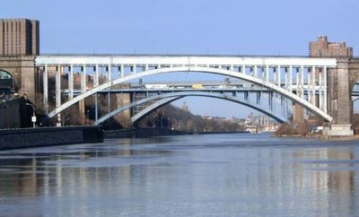
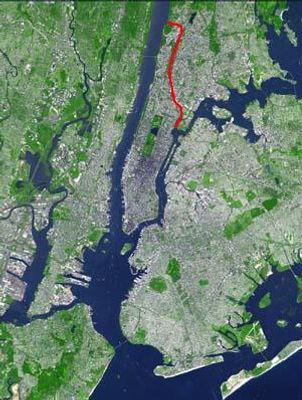
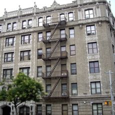
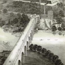
The Harlem River is a tidal strait in New York City between Manhattan and the Bronx that connects the Hudson River to the East River. The waterway extends for about 8 miles and varies in width from roughly 600 to 4000 feet (180 to 1200 meters) at different points.

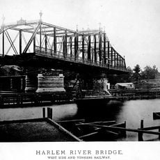
The Harlem Ship Canal was built in 1895 between Manhattan and Marble Hill to improve navigation and make the route more accessible for larger vessels. This construction changed the original course of the waterway and permanently separated Marble Hill from the rest of Manhattan.

Columbia University rowing teams train on the water and have painted their varsity emblem on a rock face along the course since 1952. This tradition connects student life with the everyday use of the waterway by athletes and recreational boaters across the city.

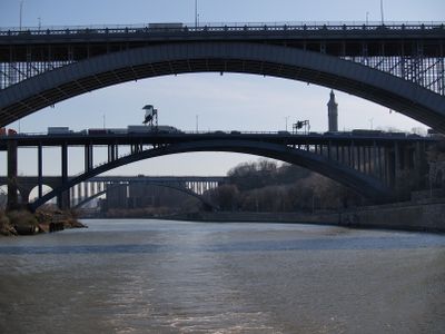
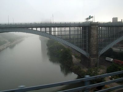
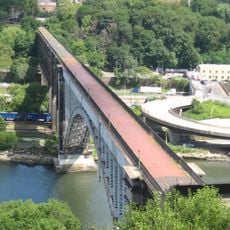
Multiple bridges, including swing and lift bridges, span the waterway and open regularly to allow vessels of different heights to pass through. Waterfront paths on both sides provide vantage points where visitors can watch boat traffic and observe the surrounding neighborhoods.

The northern section, known as Spuyten Duyvil Creek, shows strong currents where three separate tidal systems meet at different times. This feature creates complex water movements that interest both boaters and biologists studying the area.

The community of curious travelers

AroundUs brings together thousands of curated places, local tips, and hidden gems, enriched daily by 60,000 contributors worldwide.

Start exploring
Location
GPS coordinates
40.83472,-73.93412
Latest update
December 13, 2025 19:34
Around this place
Joker stairs
United States of America

Joker stairs

894 m
Rucker Park
United States of America

Rucker Park

607 m
Audubon Ballroom
United States of America

Audubon Ballroom

751 m
High Bridge
United States of America

High Bridge

905 m
Morris-Jumel Mansion
United States of America

Morris-Jumel Mansion

378 m
Malcolm X and Dr. Betty Shabazz Memorial and Educational Center
United States of America

Malcolm X and Dr. Betty Shabazz Memorial and Educational Center

755 m
Macombs Dam Bridge
United States of America

Macombs Dam Bridge

742 m
Jumel Terrace Historic District
United States of America

Jumel Terrace Historic District

425 m
Paul Robeson Residence
United States of America

Paul Robeson Residence

435 m
Duke Ellington House
United States of America

Duke Ellington House

651 m
Putnam Bridge
United States of America

Putnam Bridge

286 m
St. Rose of Lima's Church
United States of America

St. Rose of Lima's Church

562 m
Bushman Steps
United States of America

Bushman Steps

679 m
Noonan Plaza Apartments
United States of America

Noonan Plaza Apartments

867 m
North Presbyterian Church
United States of America

North Presbyterian Church

900 m
Park Plaza Apartments
United States of America

Park Plaza Apartments

730 m
Public School 11
United States of America

Public School 11

857 m
William A. Harris Garden
United States of America

William A. Harris Garden

875 m
Prince Hall Masonic Temple
United States of America

Prince Hall Masonic Temple

781 m
United States of America

Sugar Hill Children's Museum of Art & Storytelling

761 m
United States of America

St. Eugene's Church

462 m
Mitchell Square Park
United States of America

Mitchell Square Park

777 m
409 Edgecombe Avenue
United States of America

409 Edgecombe Avenue

776 m
Washington Heights Library
United States of America

Washington Heights Library

493 m
Morris-Jumel Ecological Education Garden
United States of America

Morris-Jumel Ecological Education Garden

442 m
United States of America

Costello Theatre

918 m
Highbridge Reservoir
United States of America

Highbridge Reservoir

867 m
United States of America

Scenic viewpoint

262 m
Show the full map
Reviews
Share your experience

No review yet

Discussions
Start a discussion...

No discussion yet

« Harlem River - Tidal strait between Manhattan and the Bronx, United States » is provided by Around Us (aroundus.com). Images and texts are derived from Wikimedia project under a Creative Commons license. You are allowed to copy, distribute, and modify copies of this page, under the conditions set by the license, as long as this note is clearly visible.

Discover hidden gems everywhere you go!

From secret cafés to breathtaking viewpoints, skip the crowded tourist spots and find places that match your style. Our app makes it easy with voice search, smart filtering, route optimization, and insider tips from travelers worldwide. Download now for the complete mobile experience.

Around Us App Screenshot

A unique approach to discovering new places

Le Figaro

All the places worth exploring

France Info

A tailor-made excursion in just a few clicks

20 Minutes

Around Us
Travel Guide & Maps
Download

Send to your phone

QR Code
1

Open the camera app on your mobile.

2

Point at the QR code with your camera. A notification will appear.

3

Tap the notification to open the link.